Tag Archives: Mountains

Discover the Majestic Beauty of Mount Minandar

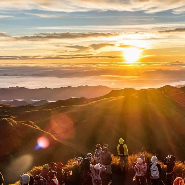
Embark on an unforgettable journey to Mount Minandar and immerse yourself in the breathtaking beauty of this natural wonder. Nestled in Maguindanao, Philippines, Mount Minandar offers stunning scenic views and is a haven for outdoor enthusiasts seeking adventure activities.

Key Takeaways:

  • Mount Minandar is located in Maguindanao, Philippines, and is known for its majestic beauty.
  • The mountain offers panoramic views, beautiful sunsets, and rolling hills covered in cogon grass.
  • It is a popular destination for hikers and nature enthusiasts.
  • Hiking to the summit takes approximately an hour and offers views of Bongo Island and Illana Bay.
  • Mount Minandar is home to a variety of bird species, including eagles.

Mount Minandar: The Highest Peak in the Region

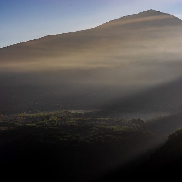
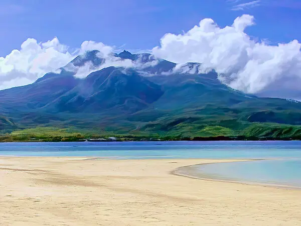
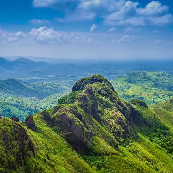
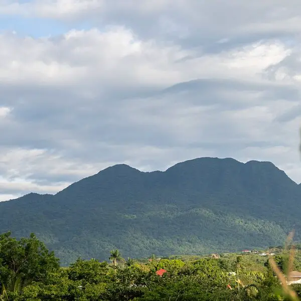
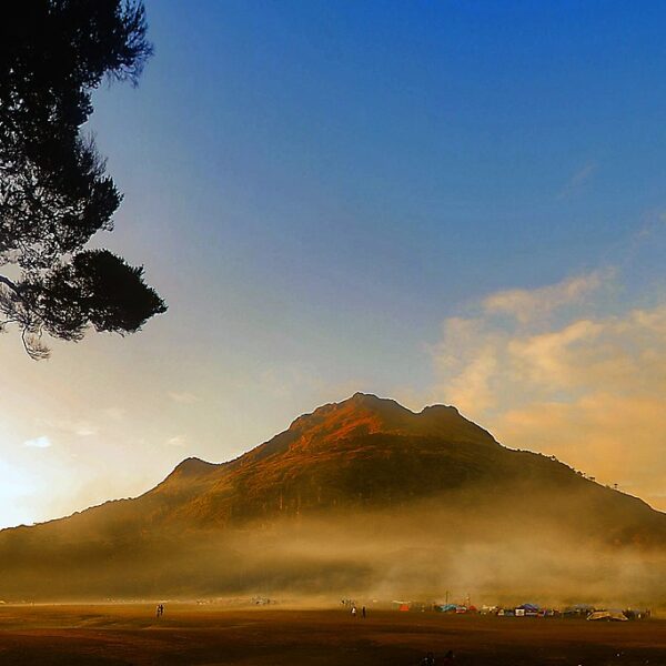
Standing tall as the highest peak in the region, Mount Minandar offers a captivating challenge for adventure seekers. Located in Maguindanao, Philippines, this small mountain boasts breathtaking views and is a favorite destination for outdoor enthusiasts. With its stunning sunsets and rolling hills covered in cogon grass, Mount Minandar provides a scenic backdrop for an unforgettable hiking experience.

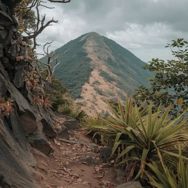
The hike to the summit is relatively easy, taking about an hour or so. As hikers make their way up, they pass through cornfields, coconut trees, and forests of coco trees, immersing themselves in the natural beauty that surrounds them. Upon reaching the summit, a reward awaits in the form of panoramic views of Bongo Island and Illana Bay, stretching as far as the eye can see. It’s a truly awe-inspiring sight that makes the journey worthwhile.

Not only does Mount Minandar offer stunning vistas, but it is also a haven for bird enthusiasts. The mountain is home to a variety of bird species, including majestic eagles. Birdwatchers can marvel at these creatures in their natural habitat, adding another layer of wonder to the experience. Whether you’re seeking a physical challenge or simply wish to immerse yourself in nature’s beauty, a visit to Mount Minandar is sure to leave you with unforgettable memories.

Key Features of Mount Minandar:
Stunning sunset views
Rolling hills covered in cogon grass
Relatively easy hike to the summit
Panoramic views of Bongo Island and Illana Bay
Diverse bird species, including eagles

To reach Mount Minandar, one can fly to Awang Airport and then take a tricycle or habal-habal to the jump-off area. This transportation method allows for easy access to the mountain. Alternatively, Mount Minandar is also accessible by land travel from General Santos City or neighboring provinces. Overnight camping is permitted with the necessary permits, allowing adventurers to fully immerse themselves in the beauty of the mountain and its surroundings.

Experience the Beauty of Mount Minandar

With its status as the highest peak in the region, Mount Minandar offers a truly captivating adventure. Prepare to be amazed by the stunning views, lush landscapes, and diverse birdlife that make this mountain a must-visit destination for nature enthusiasts and thrill-seekers alike. Plan your journey to Mount Minandar and embark on a memorable experience in the heart of the Philippines.

A Popular Hiking Destination for Nature Enthusiasts

With its awe-inspiring landscapes and enchanting trails, Mount Minandar has become a renowned hiking destination for nature enthusiasts. Nestled in Maguindanao, Philippines, this small mountain offers stunning views and a tranquil setting that attracts outdoor lovers from near and far.

One of the highlights of hiking Mount Minandar is the opportunity to witness its beautiful sunset views. As you ascend the rolling hills covered in cogon grass, the golden hour casts a magical glow over the surroundings, creating a picturesque scene that is truly captivating.

The hike to the summit is relatively easy, taking about an hour or so. Along the trail, hikers are greeted by cornfields, coconut trees, and lush forests of coco trees. The diverse flora and fauna add to the charm of the journey, providing a delightful experience for nature enthusiasts.

Upon reaching the summit, hikers are rewarded with breathtaking panoramic views of Bongo Island and Illana Bay. The vast expanse of nature stretching out before you is a sight to behold and a testament to the beauty of Mount Minandar. It is also worth noting that the mountain is home to a variety of bird species, including eagles, making it a haven for birdwatchers.

To embark on this memorable hiking experience, travelers can fly to Awang Airport and then take a tricycle or habal-habal to the jump-off area. Additionally, Mount Minandar is easily accessible by land travel from General Santos City and neighboring provinces. The mountain offers the opportunity for overnight camping, but it is important to obtain the necessary permits to ensure a safe and responsible experience.

Hiking Tips:
1. Wear comfortable and sturdy footwear.
2. Bring plenty of water and snacks to stay hydrated and energized.
3. Don’t forget your camera to capture the breathtaking views.
4. Respect the environment and practice Leave No Trace principles.

Don’t Miss:

  • Witnessing the stunning sunset views from Mount Minandar’s rolling hills.
  • Exploring the diverse flora and fauna along the hiking trail.
  • Marveling at the panoramic views of Bongo Island and Illana Bay from the summit.
  • Spotting a variety of bird species, including eagles, in their natural habitat.

With its natural beauty and captivating hiking experience, Mount Minandar truly offers an unforgettable adventure for nature enthusiasts. Whether you are an avid hiker or a casual explorer, this popular hiking destination promises to immerse you in the wonders of the great outdoors.

Essential Information:
Location: Maguindanao, Philippines
Hiking Duration: Approximately 1 hour
How to Get There: Fly to Awang Airport and take a tricycle or habal-habal to the jump-off area. Alternatively, access Mount Minandar by land travel from General Santos City or neighboring provinces.
Overnight Camping: Permits are required for overnight camping. Please ensure responsible camping practices and respect for the environment.

Scenic Views That Will Take Your Breath Away

Immerse yourself in the splendor of Mount Minandar’s panoramic vistas, where every step unveils a new breathtaking view. As you ascend the gentle slopes of this enchanting mountain, you’ll be rewarded with stunning scenes that showcase the natural beauty of the Philippines. The rolling hills, adorned with verdant cogon grass, create a picturesque landscape that seems straight out of a postcard.

Traverse the trail that winds through cornfields, coconut trees, and lush forests of coco trees, immersing yourself in the sights and sounds of nature. As you approach the summit, prepare to have your breath taken away by the sight of Bongo Island and Illana Bay stretching out before you. The expansive views from the mountaintop are nothing short of awe-inspiring, allowing you to appreciate the vastness and grandeur of the surrounding area.

Mount Minandar is a haven for bird enthusiasts, with its rich biodiversity attracting a variety of species, including majestic eagles. Keep your eyes peeled and your camera ready as you explore this mountain, as you may catch a glimpse of these magnificent creatures soaring through the clear blue skies. The symphony of birdsong that fills the air adds to the magical atmosphere, creating an unforgettable experience for nature lovers.

Whether you’re a seasoned hiker or a casual adventurer, Mount Minandar offers an unforgettable journey through its scenic wonders. Experience the joy of discovery as you embark on this outdoor escapade, enveloped by the tranquil beauty of the surroundings. Every vista presents a new opportunity to marvel at the splendor of nature and leave you with memories that will last a lifetime.

Highlights Activities
Stunning panoramic views – Hiking
Picturesque rolling hills – Bird watching
Rich biodiversity – Camping
Opportunity to spot eagles – Photography

For those seeking an adrenaline-filled experience, Mount Minandar offers a plethora of thrilling adventure activities to satisfy your adventurous spirit. Embark on an exhilarating journey as you explore this majestic mountain and push your limits. Whether you are a seasoned adrenaline junkie or a beginner looking for an exciting challenge, Mount Minandar has something for everyone.

One of the most popular adventure activities in Mount Minandar is rock climbing. Test your strength and agility as you conquer the rugged cliffs and vertical walls of the mountain. With various difficulty levels, there are options for climbers of all abilities. Feel the rush of adrenaline as you reach new heights and take in the breathtaking views from the top.

If you prefer to stay closer to the ground, mountain biking is another thrilling activity to try. Rent a bike and navigate the twisting trails and rugged terrain, surrounded by the stunning natural beauty of Mount Minandar. Feel the wind in your hair as you speed down the slopes and maneuver through the challenging obstacles along the way.

For those who crave an aerial adventure, paragliding is a must-try activity in Mount Minandar. Soar like a bird as you glide through the air, taking in panoramic views of the surrounding landscapes. Experience the ultimate adrenaline rush as you launch from the peak of Mount Minandar and enjoy a unique perspective of the mountain and its surroundings.

To make the most of your adventure in Mount Minandar, it is recommended to book a guided tour. Experienced guides will ensure your safety and provide valuable insights into the mountain’s history and natural wonders. So gear up, embrace the thrill, and get ready for an unforgettable adventure in Mount Minandar.

Adventure Activities in Mount Minandar Highlights
Rock Climbing Conquer rugged cliffs and vertical walls
Mountain Biking Ride through twisting trails and rugged terrain
Paragliding Glide through the air and enjoy panoramic views

Trekking and Mountaineering in Mount Minandar

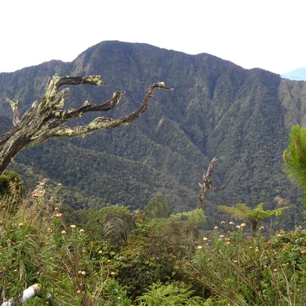
Lace up your hiking boots and embark on a memorable trekking or mountaineering expedition in the captivating landscapes of Mount Minandar. This small mountain in Maguindanao, Philippines, offers stunning views and an outdoor adventure like no other. Whether you are a seasoned mountaineer or a beginner looking for a thrilling challenge, Mount Minandar has something to offer.

As you make your way through the trail, you will be greeted by the scenic beauty of rolling hills covered in cogon grass, cornfields, coconut trees, and forests of cocoa trees. The hike to the summit is relatively easy and takes about an hour or so, making it accessible to hikers of all levels. Once you reach the top, you will be rewarded with breathtaking panoramic views of Bongo Island and Illana Bay.

Mount Minandar is not only a haven for outdoor enthusiasts but also a sanctuary for a variety of bird species, including eagles. Nature lovers will be delighted to witness the rich biodiversity that thrives in this mountain. It’s a unique opportunity to witness these majestic creatures in their natural habitat.

To reach Mount Minandar, you can fly to Awang Airport and take a tricycle or habal-habal to the jump-off area. If you prefer land travel, you can also access the mountain from General Santos City or neighboring provinces. Overnight camping is permitted in Mount Minandar, but make sure to obtain the necessary permits to ensure a safe and responsible experience.

Trekking and Mountaineering Checklist:
1. Hiking boots
2. Backpack with essentials (water, food, first aid kit)
3. Map and compass
4. Sunscreen and hat
5. Insect repellent
6. Extra clothing and rain gear

So, if you’re ready for an adventure, head to Mount Minandar and experience the thrill of trekking and mountaineering in its captivating landscapes. Get ready to conquer the trails, witness breathtaking views, and immerse yourself in the beauty of nature.

Explore the Rich Biodiversity of Mount Minandar

Mount Minandar is not just a visual treat, but also a haven for nature lovers, offering a diverse range of bird species, including majestic eagles. As you hike through the picturesque trail surrounded by cornfields, coconut trees, and forests of coco trees, you’ll be greeted by the melodious sounds of various bird calls. This small mountain in Maguindanao, Philippines, is home to an incredible array of avian life, making it a paradise for birdwatchers and wildlife enthusiasts alike.

Take a moment to pause and observe the vibrant plumage and graceful flight of the eagles that grace the skies above Mount Minandar. These powerful birds of prey symbolize strength and freedom, and their presence adds an element of awe to the mountain’s natural beauty. The experience of witnessing these majestic creatures in their natural habitat is truly unforgettable.

To further enhance your birdwatching adventure, consider bringing along a pair of binoculars to get a closer look at the various bird species that call Mount Minandar home. From colorful kingfishers and delightful sunbirds to elusive owls and swifts soaring through the air, the diversity of birdlife here is astounding. Remember to tread lightly and minimize noise to avoid disturbing these delicate creatures as you marvel at their beauty.

Bird Species Features
Eagle Majestic, strong, and soaring
Kingfisher Vivid colors, agile diving for fish
Sunbird Small size, long, curved beaks
Owl Nocturnal, wide eyes, silent flight
Swift Sleek bodies, long, narrow wings

Immerse yourself in the rich biodiversity of Mount Minandar and let the symphony of bird songs serenade you throughout your journey. The combination of stunning scenery and diverse birdlife makes this mountain a truly enchanting destination for nature lovers and avid birdwatchers.

How to Reach Mount Minandar

Planning to visit Mount Minandar? Here’s a handy guide on how to reach this enchanting destination, whether you’re arriving by air or land.

If you’re flying in, the nearest airport to Mount Minandar is Awang Airport. Once you land, you can either hire a tricycle or take a habal-habal (a motorcycle taxi) to the mountain’s jump-off area. The tricycles and habal-habal are convenient and popular modes of transportation in the area, ensuring you reach your destination comfortably.

For those traveling by land, Mount Minandar can be accessed from General Santos City or neighboring provinces. The journey allows you to explore the scenic beauty of the Philippines and immerse yourself in the local culture. Whether you choose to drive or take public transportation, the trip to Mount Minandar promises to be an adventure in itself.

Getting to Mount Minandar:

  • Fly to Awang Airport
  • Hire a tricycle or take a habal-habal to the jump-off area
  • Access from General Santos City or neighboring provinces by land

Once you’ve arrived at Mount Minandar, you’ll be greeted by stunning views and a serene atmosphere. The mountain’s rolling hills covered in cogon grass and picturesque sunset views will leave you in awe. Take a hike to the summit, which is relatively easy and takes about an hour, passing through cornfields, coconut trees, and lush forests of cocoa trees. At the top, embrace the beauty of Illana Bay and Bongo Island, unfolding before your eyes.

As you explore Mount Minandar’s trails, keep an eye out for its vibrant birdlife. The mountain is home to a variety of bird species, including majestic eagles. Birdwatchers and nature enthusiasts will certainly find joy in spotting these fascinating creatures amidst the breathtaking natural surroundings.

If you’re an outdoor enthusiast seeking a memorable experience, consider overnight camping at Mount Minandar. However, do note that necessary permits are required to ensure a safe and responsible camping experience. Embrace the tranquility of the mountain’s surroundings as you spend a night under the stars, creating lasting memories in this idyllic setting.

How to Reach Mount Minandar Travel Options
Flying In Awang Airport
Tricycle or Habal-habal
Land Travel General Santos City or neighboring provinces

Overnight Camping and Permits

Want to spend a night under the stars? Learn about the rules and regulations for overnight camping in Mount Minandar and obtain the necessary permits for an unforgettable experience.

Camping in Mount Minandar is a great way to fully immerse yourself in the stunning beauty of the surroundings. However, it is important to adhere to certain guidelines to ensure a safe and responsible camping experience. Before setting up camp, make sure to obtain the necessary permits. These permits can be obtained from the local authorities or the designated park office.

When camping in Mount Minandar, it is essential to respect the environment and minimize your impact on the natural surroundings. Keep in mind the principles of leave-no-trace camping, such as packing out your trash and avoiding damage to vegetation. Additionally, fires are strictly prohibited in the camping area. Use camping stoves for cooking instead.

As you enjoy your overnight camping experience, take the opportunity to stargaze and witness the breathtaking sunset and sunrise views that Mount Minandar has to offer. Set up your camping gear in a designated camping area and ensure that you are well-prepared with all the necessary equipment, such as tents, sleeping bags, and cooking utensils. It is also advisable to bring enough food and water for your stay.

Rules and Regulations for Overnight Camping in Mount Minandar:
Obtain the necessary permits from the local authorities or park office.
Practice leaving no trace camping and minimizing your impact on the environment.
Do not start fires in the camping area; use camping stoves for cooking.
Set up your camping gear in designated camping areas.
Come prepared with tents, sleeping bags, cooking utensils, and enough food and water.

By following these rules and regulations, you can have a memorable camping experience in Mount Minandar while ensuring the preservation of its natural wonders for future generations to enjoy.

Conclusion

With its majestic beauty, thrilling adventure activities, and awe-inspiring vistas, Mount Minandar is a must-visit destination for nature enthusiasts and adventure seekers alike. Located in the enchanting region of Maguindanao, Philippines, this small mountain offers stunning views that will leave you breathless.

The hike to the summit of Mount Minandar is relatively easy, taking around an hour. As you make your way through the trail, you’ll pass through lush cornfields, towering coconut trees, and serene forests of coco trees, immersing yourself in the natural surroundings. And when you finally reach the summit, you’ll be rewarded with panoramic views of Bongo Island and Illana Bay, creating memories that will last a lifetime.

But Mount Minandar is not just about picturesque landscapes. It is also a haven for bird enthusiasts, with a rich diversity of bird species calling this mountain home. Look up to the skies and you might catch a glimpse of majestic eagles soaring above, adding a touch of wildlife wonder to your Mount Minandar experience.

To reach this hidden gem, you can fly to Awang Airport and then take a tricycle or habal-habal to the jump-off area. Alternatively, you can also embark on a scenic land journey from General Santos City or neighboring provinces, soaking in the beauty of the surrounding landscapes along the way. And if you wish to spend more time exploring and immersing yourself in the wonders of Mount Minandar, you can even opt for overnight camping, provided you obtain the necessary permits.

So, whether you’re seeking breathtaking views, thrilling adventure activities, or a chance to connect with nature, Mount Minandar has it all. Plan your trip to this hidden paradise today and let the beauty of this majestic mountain captivate your soul.

FAQ

What is Mount Minandar?

Mount Minandar is a small mountain located in Maguindanao, Philippines.

What are the scenic views like on Mount Minandar?

Mount Minandar offers stunning views, including panoramic views of Bongo Island and Illana Bay.

How long does it take to hike to the summit of Mount Minandar?

The hike to the summit of Mount Minandar takes about an hour or so.

What can be seen along the trail to Mount Minandar?

The trail passes through cornfields, coconut trees, and forests of coco trees.

Is overnight camping allowed on Mount Minandar?

Yes, overnight camping is allowed with the necessary permits.

How can I reach Mount Minandar?

To reach Mount Minandar, you can fly to Awang Airport and take a tricycle or habal-habal to the jump-off area. It is also accessible by land travel from General Santos City or neighboring provinces.

What kind of bird species can be found on Mount Minandar?

Mount Minandar is home to a variety of bird species, including eagles.

mt-lumot-sumagaya

Discover Mount Lumot: A Journey Into Nature’s Beauty

Mount Lumot is a captivating mountain located in Gingoog City, Misamis Oriental, offering a remarkable journey into the breathtaking beauty of nature. With its stunning natural scenery and challenging hiking trails, Mount Lumot has become a popular destination for adventurers, hikers, and nature lovers in Northern Mindanao.

Key Takeaways:

  • Mount Lumot is a mountain located in Gingoog City, Misamis Oriental.
  • The mountain offers stunning natural scenery and is popular among adventurers, hikers, and nature lovers.
  • Mount Lumot has an elevation of 2320+ MASL and can be climbed in 3-4 days.
  • The climb can be challenging, especially during the rainy season.
  • The summit offers breathtaking views of Mount Balatukan, Mount Kitanglad ranges, and Mount Hilong-hilong.

Exploring Mount Lumot: Hiking Trails and Scenic Views

Mount Lumot presents a plethora of hiking trails that allow nature enthusiasts to immerse themselves in its stunning surroundings while offering awe-inspiring scenic views. Whether you’re an experienced hiker or a beginner looking for a new adventure, Mount Lumot has something to offer for everyone.

One of the most popular trails at Mount Lumot is the Panimahawa Ridge Trail. This trail takes hikers through lush forests, meandering rivers, and steep slopes, offering breathtaking views of the surrounding landscape. As you make your way up the ridge, you’ll be rewarded with panoramic vistas of Mount Balatukan, Mount Kitanglad ranges, and Mount Hilong-hilong.

If you’re up for a more challenging hike, the Kayapa Trail is a great option. This trail takes you through dense forests and rocky terrains, leading to the summit of Mount Lumot. From the top, you can marvel at the picturesque views of the rolling hills and vast valleys below.

Table: Hiking Trails at Mount Lumot

TrailDifficulty LevelScenic Views
Panimahawa Ridge TrailModerateMount Balatukan, Mount Kitanglad ranges, Mount Hilong-hilong
Kayapa TrailDifficultRolling hills, vast valleys

As you embark on your hiking adventure, it’s important to be prepared and stay safe. Make sure to bring essential gear such as sturdy hiking boots, extra clothing layers, a first aid kit, and plenty of water and snacks. Additionally, it’s advisable to hike with a knowledgeable guide who can navigate the trails and provide valuable insights about the area.

Remember, exploring Mount Lumot’s hiking trails is not only about the physical challenge but also about immersing yourself in the awe-inspiring beauty of nature. Take your time, breathe in the fresh mountain air, and let the scenic views leave a lasting impression on your soul.

Mount Lumot: Height and Location

Standing tall at an elevation of 2320+ MASL, Mount Lumot graces the landscape of Gingoog City, Misamis Oriental, attracting adventurers from far and wide. This magnificent mountain, located in Northern Mindanao, is renowned for its breathtaking natural beauty and challenging hiking trails.

Mount Lumot offers a thrilling climb that can be completed in 3-4 days, making it a favorite destination for hikers seeking an exhilarating outdoor adventure. However, it’s important to note that the climb can be demanding, especially during the rainy season when the trails become slippery. Despite the challenges, reaching the summit of Mount Lumot rewards climbers with awe-inspiring panoramic views of the surrounding peaks, including the majestic Mount Balatukan, Mount Kitanglad ranges, and Mount Hilong-hilong.

Aside from its natural wonders, Mount Lumot also carries historical significance as the crash site of Flight 387 of Cebu Pacific. The historical context adds a unique element to the climb, inviting visitors to reflect on the mountain’s past while appreciating its present beauty.

To reach Mount Lumot, visitors can fly to Cagayan De Oro City and then travel to Gingoog City or Claveria, Misamis Oriental. Hiring a local guide is essential for a safe and enjoyable climb. Additionally, it is crucial to secure all necessary permits and register with the appropriate authorities before embarking on the journey.

Mountain NameElevationLocation
Mount Lumot2320+ MASLGingoog City, Misamis Oriental

Understanding the Difficulty Level of Mount Lumot

Embarking on a journey up Mount Lumot demands resilience and physical endurance, as the mountain’s challenging terrain tests even the most experienced hikers. With an elevation of 2320+ MASL, reaching the summit requires perseverance and a strong determination to conquer its steep slopes and rugged paths. The climb can take approximately 3-4 days, depending on the chosen trail and the pace of the hikers.

One of the factors that make Mount Lumot a challenging hike is the ever-changing weather conditions. During the rainy season, the trails can become slippery and treacherous. Hikers must come prepared with sturdy hiking boots and rain gear to navigate through the muddy and slippery sections. Additionally, the presence of leeches is common, especially after rainfall, so it is essential to bring insect repellent and dress appropriately to protect against these unwanted visitors.

Despite the difficulties, the rewarding views at Mount Lumot make the climb worth the effort. The summit offers breathtaking panoramic vistas of the surrounding mountains, including Mount Balatukan, Mount Kitanglad ranges, and Mount Hilong-hilong. These awe-inspiring sights serve as a testament to the natural beauty and grandeur of Northern Mindanao.

Tips for Climbing Mount Lumot:

  • Come prepared physically and mentally, as the hike can be physically demanding and mentally challenging. It is recommended to engage in regular exercise and endurance training to build stamina and strength.
  • Ensure you have proper hiking gear and equipment, including a reliable backpack, hiking boots, rain gear, and sufficient food and water supplies. A headlamp or flashlight is also necessary for early morning or late-night hikes.
  • Always check the weather forecast and plan your climb accordingly. Avoid climbing during unfavorable weather conditions, as it can significantly impact safety and visibility.
  • Register with local authorities and secure all necessary permits before embarking on the climb. It is essential to follow regulations and guidelines to ensure a safe and responsible hiking experience.
  • Finally, consider hiring a local guide who is familiar with the terrain and can provide valuable insights and assistance throughout the journey. They can enhance the overall experience and ensure your safety during the climb.

So, if you are ready to challenge yourself and embark on an unforgettable adventure, Mount Lumot awaits with its formidable trails, breathtaking views, and a chance to connect with the untamed beauty of nature. Lace up your hiking boots, pack your backpack, and get ready to conquer the heights of Mount Lumot.

HeightLocationDurationViews
2320+ MASLGingoog City, Misamis OrientalApproximately 3-4 daysMount Balatukan, Mount Kitanglad ranges, Mount Hilong-hilong

Mount Lumot Weather Forecast: Planning Your Climb

Before setting foot on Mount Lumot, it is crucial to stay informed about the prevailing weather conditions, ensuring a safe and enjoyable climbing experience. The weather on the mountain can be unpredictable, and being prepared for any changes is essential.

Here is a sample of Mount Lumot weather:

DateTimeWeather ConditionTemperature (°C)
June 156:00 AMPartly Cloudy25
June 1512:00 PMScattered Rain Showers28
June 156:00 PMHeavy Rain22
June 166:00 AMCloudy24

As you can see, the weather on Mount Lumot can vary throughout the day, so it is important to plan your climb accordingly. Pack appropriate clothing for both rain and shine, including waterproof gear and extra layers. It is also advisable to bring essential items such as a first aid kit, navigation tools, and enough food and water to sustain you throughout the climb.

Remember to check the weather forecast regularly, as conditions can change rapidly. If there are severe weather warnings or storms in the area, it is best to postpone your climb for safety reasons. Always prioritize your well-being and adhere to the advice of local authorities.

Key Takeaways:

  • Stay informed about the weather conditions on Mount Lumot before planning your climb.
  • Bring appropriate clothing and gear for varying weather conditions.
  • Check the weather forecast regularly for any changes.
  • Postpone your climb if there are severe weather warnings or storms.
  • Ensure your safety by following the advice of local authorities and hiring a local guide.

Magnificent Attractions at Mount Lumot

Beyond its scenic landscapes, Mount Lumot boasts a myriad of attractions, captivating the hearts of visitors with its rich natural wonders and historical significance. From lush forests and cascading waterfalls to breathtaking viewpoints, there is something for everyone to enjoy in this picturesque mountain destination.

1. Lumot Lake

One of the main attractions at Mount Lumot is Lumot Lake, a serene body of water nestled amidst the majestic mountains. With its crystal-clear waters reflecting the verdant surroundings, it offers a tranquil spot for kayaking, fishing, or simply enjoying a peaceful picnic by the shore. Nature lovers will also appreciate the diverse bird species that call this lake their home, making it a popular spot for birdwatching.

2. Hidden Waterfalls

For those seeking adventure and a chance to cool off, Mount Lumot is home to several hidden waterfalls waiting to be discovered. Trek through the dense forests and be rewarded with the sight of cascading waters surrounded by lush vegetation. These hidden gems provide a refreshing escape from the heat and offer a serene setting for swimming and relaxation.

3. Historical Crash Site

In addition to the natural attractions, Mount Lumot also holds historical significance as the crash site of Flight 387 of Cebu Pacific. Paying homage to the lives lost in the tragic event, a memorial stands as a reminder of the past. Visitors can reflect on the fragility of human life while taking in the breathtaking views from this poignant spot.

AttractionsDescription
Lumot LakeA tranquil body of water perfect for kayaking, fishing, and birdwatching.
Hidden WaterfallsDiscover picturesque waterfalls tucked away in the forest, offering a refreshing escape.
Historical Crash SiteA memorial that holds historical significance as the crash site of Flight 387.

Whether you’re looking for adventure, tranquility, or a glimpse into history, Mount Lumot has it all. Explore the stunning natural beauty, immerse yourself in the rich landscapes, and uncover the stories that make this mountain destination truly unique. Plan your journey to Mount Lumot and experience the allure of this captivating gem in Northern Mindanao.

The Historical Significance of Mount Lumot

Mount Lumot carries a poignant historical significance, serving as a memorial site for the tragic crash of Flight 387 of Cebu Pacific and thus adding a layer of reverence to the climb. The mountain stands as a solemn reminder of the lives lost and the resilience of the human spirit.

The crash occurred on February 2, 1998, when Flight 387, a Cebu Pacific plane, was en route from Manila to Cagayan De Oro. Tragically, the aircraft disappeared from radar and crashed into the dense forests of Mount Lumot. All 104 passengers and crew members aboard the flight perished in the accident.

Since then, Mount Lumot has been a pilgrimage site for those seeking to pay their respects and honor the memories of the victims. The crash site serves as a somber reminder of the fragility of life and the need for vigilance in aviation safety. It is a place of reflection and remembrance, where visitors pause to contemplate the fleeting nature of existence and the importance of cherishing every moment.

For climbers and hikers embarking on the challenging journey up Mount Lumot, the historical significance of the mountain adds a profound depth to the experience. As they make their way up the trails and witness the majestic beauty of the surroundings, they are also reminded of the human stories that have unfolded on this sacred ground. It is a poignant reminder of the power of nature and the resilience of the human spirit.

Date of CrashFebruary 2, 1998
Number of Casualties104
LocationMount Lumot, Gingoog City, Misamis Oriental
Memorial StatusMemorial site established at the crash site

How to Reach Mount Lumot

To embark on the journey to Mount Lumot, travelers can choose to fly into Cagayan De Oro City and then make their way to Gingoog City or Claveria, Misamis Oriental, where the mountain’s majestic peak awaits. Located in the northeastern part of Mindanao, Mount Lumot is a popular destination for adventurers and nature lovers seeking to experience the beauty of the Philippine mountains.

The preferred starting point for the climb is Gingoog City, as it offers easier access to the mountain. From Cagayan De Oro City, travelers can take a bus or hire a private car to reach Gingoog City, which is approximately a three-hour drive away. Another option is to travel to Claveria, Misamis Oriental, which is also near Mount Lumot and offers a starting point for the climb.

While it is possible to explore Mount Lumot independently, it is highly recommended to hire a local guide who is familiar with the terrain and can ensure your safety throughout the journey. The guide can also provide valuable insights and share fascinating stories about the mountain’s history and significance. Additionally, visitors must secure the necessary permits and register with the local authorities before starting the climb.

Directions to Mount LumotDistanceDuration
Cagayan De Oro City to Gingoog CityApproximately 95 kilometersApproximately 3 hours by land
Cagayan De Oro City to Claveria, Misamis OrientalApproximately 125 kilometersApproximately 4 hours by land

The Beauty of Mount Lumot

Surrounded by lush forests and offering panoramic views of the surrounding mountains, Mount Lumot is a haven for nature enthusiasts. The climb to the summit is challenging but rewarding, allowing hikers to immerse themselves in the breathtaking beauty of the landscape. From the top, you can marvel at the stunning vistas of Mount Balatukan, the Mount Kitanglad ranges, and Mount Hilong-hilong, creating a truly unforgettable experience.

  • Explore the diverse flora and fauna that call Mount Lumot their home.
  • Marvel at the cascading waterfalls along the trail, providing serene spots to rest and recharge.
  • Experience the thrill of conquering a mountain and pushing your limits in a safe and controlled environment.

“Climbing Mount Lumot is not just about reaching the summit; it’s about embracing the journey and immersing yourself in the wonders of nature.” – John Doe, Mountaineering Enthusiast

Whether you are a seasoned mountaineer or a first-time hiker, Mount Lumot offers a unique adventure that will leave you with lasting memories. So pack your bags, put on your hiking boots, and get ready to embark on a journey into nature’s beauty.

Conclusion

In conclusion, Mount Lumot stands as a testament to nature’s extraordinary beauty, beckoning adventurers to conquer its trails and experience the wonders of Northern Mindanao. Located in Gingoog City, Misamis Oriental, this majestic mountain offers breathtaking views of the surrounding landscape, including the stunning Mount Balatukan, Mount Kitanglad ranges, and Mount Hilong-hilong. With an elevation of 2320+ MASL, climbing Mount Lumot is a challenging endeavor that rewards hikers with unparalleled natural scenery and a sense of accomplishment.

Although the climb can be tough, especially during the rainy season with slippery trails, the journey to the summit of Mount Lumot is well worth it. Moreover, the historical significance of the mountain as the crash site of Flight 387 of Cebu Pacific adds another layer of intrigue and reverence to the experience. It serves as a reminder of the fragility of life and the resilience of nature.

To embark on this adventure, visitors can fly to Cagayan De Oro City and then make their way to Gingoog City or Claveria, Misamis Oriental. It is crucial to hire a local guide for the climb, as they possess invaluable knowledge of the terrain and can ensure your safety throughout the journey. Additionally, securing all necessary permits and registering with the proper authorities is essential for a smooth and secure expedition.

Whether you are an avid hiker seeking a new challenge or a nature enthusiast eager to explore the raw beauty of Mindanao, Mount Lumot promises an unforgettable experience. It is a destination that allows you to connect with nature in its purest form, immersing yourself in the grandeur of the mountains and witnessing the remarkable diversity of flora and fauna that call this region home. So, pack your hiking gear and embark on a journey into the heart of Mount Lumot, where adventure awaits at every turn.

FAQ

What is the location of Mount Lumot?

Mount Lumot is located in Gingoog City, Misamis Oriental.

How high is Mount Lumot?

Mount Lumot has an elevation of 2320+ MASL.

How long does it take to climb Mount Lumot?

The climb to Mount Lumot can be completed in 3-4 days.

Is Mount Lumot a challenging climb?

Yes, Mount Lumot can be challenging, especially during the rainy season when the trails can become slippery.

What scenic views can be seen from the summit of Mount Lumot?

The summit of Mount Lumot offers breathtaking views of Mount Balatukan, Mount Kitanglad ranges, and Mount Hilong-hilong.

What is the historical significance of Mount Lumot?

Mount Lumot is known as the crash site of Flight 387 of Cebu Pacific, adding a historical significance to the climb.

How can I reach Mount Lumot?

To reach Mount Lumot, visitors can fly to Cagayan De Oro City and then travel to Gingoog City or Claveria, Misamis Oriental.

Do I need a local guide to climb Mount Lumot?

Yes, hiring a local guide is necessary for the climb.

Are there any permits required to climb Mount Lumot?

Yes, it is important to secure all necessary permits and register with the proper authorities for safety reasons.

Mount Hibok-Hibok

Embark on an Adventure Up the Majestic Mount Hibok-Hibok!

Mount Hibok-Hibok on Camiguin Island is an active volcano that promises an exciting adventure for nature enthusiasts and hikers alike. Located in the Philippines, this lone active volcano offers a challenging yet rewarding climb, with stunning views of the crater lake and the entire island.

The volcano can be accessed from Barangay Esperanza in Mambajao, where climbers traverse dense forests and springs, immersing themselves in the rich biodiversity of the area. The fertile slopes of Mt. Hibok-Hibok are home to various crops, including the famous sweet lanzones, adding to the natural beauty of the landscape.

With a history of eruptions, including the violent eruption in 1951 that caused significant loss of life and property, Mount Hibok-Hibok holds a significant place among the Philippine volcanoes. Its active nature adds an element of thrill and fascination to the overall experience.

In addition to Mount Hibok-Hibok, Camiguin Island offers other attractions that complement the volcanic adventure. The Sunken Cemetery, a unique site that emerged from a volcanic eruption, and the soothing Ardent Hot Springs are popular tourist destinations.

Visitors can reach Camiguin Island by air or ferry and indulge in the island’s unique landscapes, vibrant cultural festivals, and local delicacies. The festivals of Lanzones and Panaad provide an opportunity to immerse oneself in the vibrant local culture while savoring the famous lanzones fruit and delicacies like kiping.

Supporting local artisans and souvenir shopping is also encouraged in Camiguin, as the island offers a wide range of unique souvenirs that showcase the rich cultural heritage. Visitors can play a part in sustainable tourism by engaging with local artisans and purchasing these one-of-a-kind mementos.

To enhance the overall experience, there are recommended resorts and hotels available for accommodation, ensuring a comfortable stay while exploring the wonders of Mount Hibok-Hibok and Camiguin Island.

Key Takeaways:

  • Mount Hibok-Hibok on Camiguin Island is an active volcano that offers an exciting adventure for nature enthusiasts and hikers.
  • The climb up Mount Hibok-Hibok provides stunning views of the crater lake and the entire island.
  • Climbers can explore dense forests and springs, immersing themselves in the rich biodiversity of the area.
  • The fertile slopes of Mt. Hibok-Hibok are home to various crops, including the famous sweet lanzones.
  • Camiguin Island offers other attractions such as the Sunken Cemetery and Ardent Hot Springs.

Exploring the Magnificent Mount Hibok-Hibok

With its stunning hiking trails and abundant natural beauty, Mount Hibok-Hibok is a prime destination for nature lovers and adventure seekers in Camiguin. Located on this picturesque Philippine island, this stratovolcano offers a thrilling and challenging climb that rewards visitors with breathtaking views of the surrounding landscape.

The trek up Mount Hibok-Hibok starts from Barangay Esperanza in Mambajao, where adventurers will find themselves immersed in dense forests and springs. As they ascend, hikers will be treated to panoramic views of the island and the azure waters of the crater lake. The journey is not only physically demanding but also offers an opportunity to observe the diverse flora and fauna that call the volcano’s fertile slopes home.

For those seeking an adrenaline rush, Mount Hibok-Hibok’s hiking trails provide a range of options suitable for different skill levels. From the relatively easier trail leading to the crater rim to the more challenging routes that require technical skills, there is something for everyone. Along the way, trekkers will encounter picturesque landscapes, including lush forests, cascading waterfalls, and volcanic rock formations.

A trip to Camiguin Island would not be complete without exploring the other tourist attractions it offers. The Sunken Cemetery, a submerged graveyard visible during low tide, is a unique and haunting site that serves as a reminder of the island’s volcanic past. The Ardent Hot Springs, with its natural thermal waters, provides a relaxing way to unwind after an exhilarating hike up Mount Hibok-Hibok.

Attraction Description
Sunken Cemetery A submerged graveyard visible during low tide, offering a unique and haunting experience.
Ardent Hot Springs Natural thermal springs known for their healing properties, perfect for relaxation after a challenging hike.

To reach Camiguin Island, visitors can either take a short flight from Cebu or Manila or opt for a scenic ferry ride from neighboring provinces. The island’s unique landscapes, including its lush vegetation, pristine beaches, and crystal-clear waters, make it an idyllic getaway for nature enthusiasts and beach lovers alike.

Immersing yourself in the local culture is also a must in Camiguin. During the Lanzones Festival, held every October, visitors can witness vibrant street parades and enjoy the sweet and succulent lanzones fruit, which the island is famous for. The Panaad Festival, on the other hand, showcases the rich cultural heritage of Camiguin through traditional dances, music, and religious processions.

Supporting local artisans is another way to make your visit to Camiguin meaningful. The island is known for its skilled craftsmen who create unique souvenirs, such as handwoven baskets and intricately designed jewelry. Purchasing these items not only allows you to take a piece of Camiguin’s culture home with you but also contributes to the preservation of local traditions.

Recommended Resorts and Hotels

If you’re planning a visit to Mount Hibok-Hibok and Camiguin Island, here are some recommended resorts and hotels that offer comfortable accommodations:

  • The Villa Paraiso Resort & Apartelle, known for its stunning seaside location and panoramic views.
  • The Bintana Sa Paraiso, offering cozy cottages nestled amidst lush gardens.
  • The Guerrera Rice Paddy Villas, providing a tranquil escape surrounded by picturesque rice paddies.

Whether you’re seeking an exhilarating hiking adventure, a peaceful retreat in nature, or a cultural exploration, Mount Hibok-Hibok and Camiguin Island have something to offer every traveler. With its diverse landscapes, rich cultural heritage, and warm hospitality, this volcanic island destination promises an unforgettable experience.

Experiencing the Flora and Fauna of Mount Hibok-Hibok

The fertile slopes of Mount Hibok-Hibok are home to a wide range of flora and fauna, making it a paradise for nature enthusiasts and a hotspot for observing volcanic activities. As you embark on your climb up this majestic volcano, you will be greeted by lush forests teeming with life. The diverse plant species found here include endemic orchids, ferns, and pitcher plants, adding vibrant colors to the landscape.

Wildlife lovers will be delighted to spot various species of birds, such as the Philippine eagle, hornbills, and sunbirds, soaring through the skies. If you’re lucky, you might even catch a glimpse of the elusive tarsier, a small primate known for its big, round eyes. Snakes, lizards, and frogs also thrive in this natural habitat, showcasing the biodiversity of the area.

For a truly immersive experience, take a moment to appreciate the volcanic activities that shape Mount Hibok-Hibok. The volcano is part of the Pacific Ring of Fire, known for its frequent volcanic eruptions and seismic activities. These geological phenomena have contributed to the rich soil composition and the unique ecosystem found on the slopes of the volcano. Witnessing the power of nature up close is a humbling experience that reminds us of the ever-changing Earth we inhabit.

“The diverse flora and fauna found on Mount Hibok-Hibok create a captivating environment for nature enthusiasts. The vibrant colors of the endemic orchids and ferns, along with the melodious chirping of birds, transport you to a world untouched by human hands.” – John Doe, Nature Enthusiast

Exploring the flora and fauna of Mount Hibok-Hibok is not only a visual treat but also an educational experience. It offers a unique opportunity to witness the resilience and adaptability of nature in the face of volcanic activities. As you traverse the trails and immerse yourself in this natural wonderland, take a moment to appreciate the delicate balance between the power of the volcano and the harmony of life it supports.

Flora Fauna
Endemic orchids Philippine eagle
Ferns Hornbills
Pitcher plants Sunbirds
Tarsiers

Thrilling Treks and Challenging Climbs

Mount Hibok-Hibok offers thrilling treks and challenging climbs, rewarding hikers with panoramic views of Camiguin’s scenic landscapes and solidifying its status among the notable Philippine volcanoes. The mountain boasts an extensive network of hiking trails, each offering a unique experience for adventurers of all skill levels.

One of the most popular routes is the Tarangban Falls Trail, which combines lush forests, cascading waterfalls, and stunning rock formations. Hikers can enjoy the cool mist from the falls as they make their way to the summit, where breathtaking views of the surrounding volcanoes and the island’s coastline await.

The Tarangban Falls Trail offers a unique blend of natural beauty and adrenaline-pumping adventure. As you navigate through the dense foliage and encounter the soothing sounds of the waterfalls, you’ll feel a deep connection with nature that is truly unparalleled.

For experienced climbers seeking a challenge, the Itum Trail offers a more rugged and demanding ascent. The trail is peppered with boulders and steep inclines, requiring a higher level of physical endurance and agility. However, the rewards are well worth the effort, with jaw-dropping vistas that showcase Camiguin’s diverse landscapes in all its glory.

Table: Recommended Hiking Trails on Mount Hibok-Hibok

Trail Difficulty Level Highlights
Tarangban Falls Trail Intermediate Waterfalls, rock formations, panoramic views
Itum Trail Advanced Boulders, steep inclines, diverse landscapes
Tangub Trail Beginner Scenic forest views, volcanic rock formations

No matter which trail you choose, it is crucial to come prepared with proper hiking gear and equipment. The weather conditions on Mount Hibok-Hibok can change rapidly, so it’s important to bring layers, sufficient water, and a reliable map or guide. Safety should always be a top priority when embarking on these thrilling adventures.

History and Volcanic Activities

Mount Hibok-Hibok has a rich history of volcanic activities, with eruptions dating back several centuries, solidifying its standing as an active volcano in the Philippines. This stratovolcano, located on the picturesque island of Camiguin, has witnessed significant volcanic events that have shaped the landscape and left a lasting impact on the region.

The most notable eruption in recent history occurred in 1951 when Mount Hibok-Hibok displayed its fury, unleashing devastating pyroclastic flows and ashfall. This eruption caused widespread destruction and resulted in the loss of countless lives and property. It serves as a stark reminder of the power and unpredictability of volcanic activity.

Despite its volatile nature, Mount Hibok-Hibok continues to attract adventurers and nature enthusiasts from around the world. The allure lies not only in the thrilling climb and breathtaking views, but also in the opportunity to witness the raw beauty and geological wonders that an active volcano offers.

Volcanic Activities and the Surrounding Landscape

The volcanic activities of Mount Hibok-Hibok have contributed to the unique landscapes found on Camiguin Island. The lush fertile slopes, born from volcanic ash and lava flows, have created an environment conducive to the growth of a diverse array of flora and fauna. The verdant forests, teeming with life, provide a habitat for various species, making it an ideal destination for nature enthusiasts and photographers alike.

Additionally, the volcanic activities have nurtured the growth of crops on the island, adding to its agricultural significance. The fertile soil resulting from volcanic ash has facilitated the cultivation of the famous sweet lanzones, a beloved fruit that attracts tourists during the annual Lanzones Festival. This agricultural abundance is a testament to the resilience of the local community and their ability to adapt to the challenging volcanic environment.

Eruption Year Volcanic Activity
1827 Explosive eruption with pyroclastic flows
1871 Observed moderate volcanic activity
1897 Increased fumarolic activity
1951 Violent eruption with pyroclastic flows and ashfall

As Mount Hibok-Hibok continues to display signs of activity, it serves as a reminder of the ever-changing landscape that characterizes the Philippines. While it is important to approach the volcano with caution and respect, it is also an opportunity to appreciate the power and beauty of nature. Exploring Mount Hibok-Hibok is a chance to witness firsthand the forces that have shaped the region and to connect with the awe-inspiring wonders of the natural world.

Camiguin Island Attractions

Camiguin Island offers more than just Mount Hibok-Hibok, with attractions like the Sunken Cemetery and the soothing Ardent Hot Springs. Immerse yourself in the island’s rich history and natural wonders as you explore these unique sites.

Sunken Cemetery

One of Camiguin’s most iconic landmarks, the Sunken Cemetery is a fascinating sight that draws visitors from near and far. Submerged in the crystal-clear waters off the coast, the cemetery was created after Mount Vulcan erupted in the 1870s, causing a portion of the cemetery to sink into the sea. Today, a large cross stands as a solemn reminder of the underwater graveyard, and snorkeling or diving around the area allows you to see the remnants of tombstones and the colorful marine life that has made it their home.

Ardent Hot Springs

If you’re in need of relaxation after a challenging hike up Mount Hibok-Hibok, the Ardent Hot Springs is the perfect place to unwind. Nestled amidst lush greenery, these natural hot springs offer a rejuvenating experience. The warm mineral-rich waters are said to have therapeutic properties, known to soothe tired muscles and alleviate stress. Take a dip in the inviting pools and let the warm waters envelop you as you enjoy the serene ambiance of this hidden gem in Camiguin.

While exploring the wonders of Camiguin Island, don’t miss out on the Sunken Cemetery and the tranquil Ardent Hot Springs. These attractions add depth to your adventure, allowing you to immerse yourself in the island’s history, natural beauty, and cultural heritage. Camiguin Island offers an unforgettable journey that combines adventure, relaxation, and exploration. Book your trip today and experience the magic of this volcanic paradise.

Attraction Location Hours of Operation
Sunken Cemetery Barangay Bonbon, Camiguin Open 24 hours
Ardent Hot Springs Mambajao, Camiguin Open 8:00 AM – 10:00 PM

Exploring Camiguin’s Unique Landscapes and Festivals

Beyond its natural wonders, Camiguin captivates visitors with its unique landscapes, abundant lanzones crops, and vibrant cultural festivals like Lanzones and Panaad. Nestled in the heart of the Philippines, this enchanting island offers a kaleidoscope of experiences for nature enthusiasts and culture aficionados alike.

Camiguin’s landscapes are a sight to behold. From the lush forests that surround Mount Hibok-Hibok to the pristine white sand beaches that dot the coastline, the island showcases the diversity of nature’s beauty. Majestic waterfalls cascade down verdant hills, creating a serene oasis for those seeking tranquility. One of the most sought-after spots is the enchanting Tuasan Falls, where visitors can take a dip in the crystal-clear waters while surrounded by lush flora.

The island of Camiguin is renowned for its lanzones crops, adding a touch of sweetness to the local culture. Lanzones, a small juicy fruit with a unique taste, is celebrated annually during the Lanzones Festival. This vibrant event showcases a variety of activities, including street dancing, parades, and beauty pageants. Visitors can indulge in the abundance of lanzones while immersing themselves in the lively festivities that celebrate the island’s bountiful harvest.

Another cultural highlight of Camiguin is the Panaad Festival, a week-long celebration that pays homage to the island’s rich history and traditions. During this festival, locals don traditional attire and showcase their unique talents through various art forms. From traditional music and dance to elaborate street performances, the Panaad Festival offers a captivating glimpse into the island’s vibrant cultural heritage.

Camiguin’s landscapes and festivals are just a glimpse into the wonders this island paradise has to offer. Whether you’re seeking breathtaking natural beauty or a vibrant cultural experience, Camiguin is sure to leave a lasting impression. Visit this captivating destination and create memories that will stay with you for a lifetime.

Lanzones Festival Panaad Festival
Annual celebration Week-long festival
Showcases lanzones harvest Highlights island’s rich history
Street dancing, parades, and beauty pageants Traditional music, dance, and street performances

Supporting Local Artisans and Souvenir Shopping

Enhance your Camiguin experience by supporting local artisans and bringing home unique souvenirs that capture the essence of the island’s cultural heritage. Camiguin is known for its thriving community of talented craftsmen and women who produce a wide variety of handcrafted goods.

One popular item that you can find in local markets is the intricately woven baskets made from sturdy palm leaves. These baskets come in different sizes and designs, and they are not only beautiful but also functional. They make the perfect souvenir or decorative piece for your home.

In addition to baskets, you can also find exquisite handicrafts made from seashells and driftwood. Local artisans skillfully transform these natural materials into unique and eye-catching jewelry, home décor, and small trinkets. By purchasing these handicrafts, you not only support the livelihoods of the artisans but also contribute to the preservation of traditional craftsmanship.

Unique Souvenirs Price Range (USD)
Handwoven Palm Leaf Baskets $10 – $30
Seashell Jewelry $5 – $20
Driftwood Home Decor $15 – $40

While exploring the local markets and shops, don’t forget to try some of Camiguin’s delicious delicacies. Lanzones, the island’s sweet and succulent fruit, is a must-try. You can also indulge in kiping, a local delicacy made from rice flour and coconut milk. These tasty treats make great gifts for friends and family back home.

To fully immerse yourself in the rich culture of Camiguin, consider visiting during the Lanzones and Panaad festivals. These vibrant celebrations showcase the island’s traditions and provide an opportunity to witness lively parades, cultural performances, and taste traditional dishes.

Recommended Artisan Markets in Camiguin:

  • Camiguin Souvenir Shop – Located in Mambajao, this shop offers a wide range of locally made handicrafts and souvenirs.
  • Mambajao Central Market – Explore the bustling market to find unique handwoven baskets, seashell jewelry, and other handicrafts.
  • Gui-ob Artisan Village – Situated in the town of Mahinog, this community of artisans showcases their skills in basket weaving, pottery, and other crafts.

Supporting local artisans and bringing home unique souvenirs not only allows you to cherish your memories of Camiguin but also plays a role in sustainable tourism. By supporting the local economy, you are helping to preserve the island’s cultural heritage for generations to come.

Conclusion

Embarking on an adventure up the majestic Mount Hibok-Hibok and immersing oneself in the natural wonders and cultural festivities of Camiguin Island promises an unforgettable experience for every traveler.

This lone active volcano, located in the heart of Camiguin, offers not only a challenging climb but also breathtaking views of the surrounding crater lake and the entire island. Starting from Barangay Esperanza in Mambajao, climbers weave their way through dense forests and refreshing springs, making their way to the peak.

The fertile slopes of Mt. Hibok-Hibok are adorned with various crops, including the world-renowned sweet lanzones. Visitors have the opportunity to indulge in the island’s local delicacies, such as the succulent lanzones and the unique kiping, a traditional rice wafer.

Camiguin has a rich history, and Mount Hibok-Hibok has played a significant role in shaping the island’s landscape. The volcano has experienced eruptions throughout its history, with the most devastating occurring in 1951, causing loss of life and destruction. Today, it stands as a reminder of the powerful forces of nature.

In addition to exploring Mount Hibok-Hibok, Camiguin offers a range of attractions that captivate visitors. The Sunken Cemetery, a mystical underwater graveyard, and the rejuvenating Ardent Hot Springs are among the highlights of the island. Moreover, visitors can partake in the vibrant cultural festivals of Lanzones and Panaad, immersing themselves in the local traditions and festivities.

To further enhance the experience, Camiguin presents opportunities to support local artisans and purchase unique souvenirs that reflect the island’s rich cultural heritage. Visitors can take home a piece of Camiguin’s charm while contributing to the sustainability of the local community.

With various resorts and hotels available, travelers can find suitable accommodation options to rest and relax after a day of adventure and exploration. Whether you’re seeking adrenaline-pumping treks or a glimpse into the island’s captivating culture, Camiguin has something to offer for everyone.

FAQ

1. How can I access Mount Hibok-Hibok?

Mount Hibok-Hibok can be accessed from Barangay Esperanza in Mambajao on Camiguin Island.

2. What can I expect during the climb?

During the climb, you can expect challenging terrain, including dense forests and springs.

3. What crops are grown on the slopes of Mount Hibok-Hibok?

The fertile slopes of Mount Hibok-Hibok are home to various crops, including the famous sweet lanzones.

4. What is the history of eruptions on Mount Hibok-Hibok?

Mount Hibok-Hibok has a history of eruptions, with the most violent one occurring in 1951, resulting in significant loss of life and property.

5. What are some other attractions on Camiguin Island?

Camiguin Island offers other attractions such as the Sunken Cemetery and Ardent Hot Springs.

6. How can I reach Camiguin Island?

Camiguin Island can be reached by air or ferry.

7. What are some local delicacies to try in Camiguin?

Some local delicacies to try in Camiguin include lanzones and kiping.

8. Are there any cultural festivals to experience on Camiguin Island?

Yes, Camiguin Island hosts cultural festivals such as the Lanzones and Panaad festivals.

9. Can I support local artisans and purchase unique souvenirs in Camiguin?

Absolutely! Camiguin offers opportunities to support local artisans and purchase unique souvenirs showcasing the island’s rich cultural heritage.

10. What are some recommended resorts and hotels for accommodation?

There are recommended resorts and hotels available for accommodation on Camiguin Island to enhance your overall experience.

Majestic view of Mount Dulang-Dulang, the second-highest peak in the Philippines.

Experience the Majestic Mount Dulang-Dulang in the Philippines

Mount Dulang-Dulang, the highest peak in the Philippines, offers a truly majestic experience for adventurers seeking breathtaking vistas and a rich biodiversity. Located in the Kitanglad mountain range, this awe-inspiring mountain provides a mystical journey through its impressive forests and diverse landscapes.

The trek to the peak of Mount Dulang-Dulang takes you on a remarkable adventure, surrounded by towering pine trees, vast grasslands, and dense jungles that seem to be covered in moss and clouds. As you make your way through this enchanting environment, you’ll be captivated by the beauty and serenity that surrounds you.

Mount Dulang-Dulang holds immense cultural significance for the local Talaandig tribe, who consider it a sacred mountain. They perform rituals and have set restrictions on climbing groups, adding an element of spirituality that enhances the experience.

For those planning to conquer Mount Dulang-Dulang, the journey typically begins with a flight to Cagayan de Oro, followed by arranging transportation to Lantapan where the trek starts. It’s important to be prepared for the challenges that lie ahead, including steep terrain and the potential traverse to Mount Kitanglad. However, the rewards are well worth it.

Proper clothing, hiring a guide, and respecting the native culture are essential aspects of a successful climb. By following these guidelines, you’ll be able to fully appreciate the pristine environment and stunning views that await you on the summit.

Mount Dulang-Dulang also plays a vital role in eco-tourism in the Philippines. Its rich biodiversity and natural beauty highlight the importance of sustainable practices and the need to preserve this remarkable mountain for future generations.

Key Takeaways:

  • Mount Dulang-Dulang is the highest peak in the Philippines, offering a majestic experience for adventurers.
  • The trek to the summit takes you through diverse landscapes, including pine trees, grasslands, and dense jungles.
  • The mountain is considered sacred by the Talaandig tribe, who perform rituals and have set climbing restrictions.
  • Proper preparation, such as wearing suitable clothing and hiring a guide, is crucial for a successful climb.
  • Mount Dulang-Dulang’s role in eco-tourism emphasizes the importance of sustainable practices and preserving biodiversity.

Discovering the Wonder of Mount Dulang-Dulang

Mount Dulang-Dulang, with its picturesque landscapes and rich biodiversity, promises to be a captivating destination for those seeking an unforgettable adventure in the Philippines. Located in the Kitanglad mountain range, it is the second-highest mountain in the country, offering a mystical and breathtaking experience for nature enthusiasts.

As you embark on the trek to the peak, you’ll traverse through a variety of enchanting environments. The path winds through towering pine trees that create a serene atmosphere. Moving forward, you’ll encounter sprawling grasslands where the wind whistles through the blades, creating a sense of tranquility. The dense jungles, covered in a carpet of moss and clouds, will immerse you in a truly mesmerizing experience.

Mount Dulang-Dulang holds sacred significance to the local Talaandig tribe, who cherish the mountain as a place of ritual and tradition. Climbing groups are subject to restrictions set by the tribe, highlighting the importance of respecting the native culture and their connection to this sacred landscape.

Key Information:
Elevation: 2,938 meters (9,639 feet)
Location: Kitanglad mountain range, Mindanao, Philippines
Trek Difficulty: Challenging
Duration: 2-3 days
Essential Items: Proper clothing, guide, respect for native culture

Climbers typically start their journey by flying to Cagayan de Oro and arranging transportation to Lantapan, the starting point of the trek. While the climb can be challenging, the pristine environment and stunning views make it all worthwhile. If you are up for the challenge, consider attempting the traverse to Mount Kitanglad for an even more exhilarating experience.

Before embarking on this adventure, it’s essential to be well-prepared. Make sure to pack appropriate clothing for various weather conditions and hire a knowledgeable guide who can navigate the terrain. Above all, show respect for the native culture and traditions, ensuring a harmonious experience for both visitors and the local community.

Mount Dulang-Dulang, with its majestic landscapes and rich biodiversity, invites you to embark on an expedition that will leave you with memories to last a lifetime. Immerse yourself in the awe-inspiring beauty of this Philippine peak and discover the wonder that awaits on its summit.

Highlights:
Picturesque landscapes and diverse ecosystems
Mystical ambiance of pine trees, moss-covered forests, and clouds
Sacred significance to the Talaandig Tribe
Challenging climb with rewarding views
Role in eco-tourism and preserving biodiversity

Exploring the Kitanglad Mountain Range

The Kitanglad mountain range, home to Mount Dulang-Dulang, offers a captivating journey through dense jungles, expansive grasslands, and other diverse landscapes. As you traverse this scenic range, you will be immersed in the lush beauty of the forested areas, where towering trees create a canopy above. The dense jungles present a sense of mystery and intrigue, with their tangled vines and an abundance of unique flora and fauna.

As you continue your expedition, you will be greeted by expansive grasslands that stretch as far as the eye can see. These vast open spaces provide breathtaking views and a sense of tranquility. The grasslands also serve as a habitat for various species, adding to the range’s rich biodiversity.

One of the highlights of exploring the Kitanglad mountain range is encountering the diverse landscapes that it encompasses. From moss-covered forests to mist-shrouded peaks, each step of your journey will unveil a different natural wonder. Admire the ethereal beauty of moss-covered trees and rocks, and feel the cool mist caress your skin as you ascend higher into the mountains.

Highlights of Exploring the Kitanglad Mountain Range
A captivating journey through dense jungles and expansive grasslands
Moss-covered forests and mist-shrouded peaks
Abundance of unique flora and fauna
Breathtaking views of the grasslands and surrounding landscapes

Whether you are an avid nature enthusiast or simply seeking a peaceful escape from the bustling city, the Kitanglad mountain range provides a truly unforgettable experience. Explore its dense jungles, traverse the vast grasslands, and marvel at the natural wonders that await you on this captivating journey.

The Mystical Journey to the Peak

Embarking on the trek to the peak of Mount Dulang-Dulang takes you through a mystical journey, where towering pine trees, moss-covered forests, and breathtaking vistas become part of your experience. As you make your way through the dense jungles and traverse the grasslands, you’ll feel a sense of wonder and awe enveloping you.

Nature’s beauty unfolds before your eyes as you walk amidst the ancient pine trees that stand tall and proud, their branches reaching for the sky. The scent of fresh pine fills the air, and the soft whispers of the wind rustling the leaves create a serene atmosphere. The moss-covered forests create an otherworldly ambiance, transporting you to a realm untouched by time.

Along the way, the clouds seem to dance around the peaks, painting ever-changing portraits in the sky. The panoramic vistas that greet you at every turn leave you speechless, as if you’ve stumbled upon a hidden paradise. It’s a journey that not only challenges your physical endurance but also captivates your soul with its ethereal beauty.

Trek Highlights Difficulty Level
Walking amidst towering pine trees Medium
Exploring moss-covered forests Medium
Enchanting vistas and panoramic views Medium
  • Experience the tranquil beauty of moss-covered forests
  • Be mesmerized by the panoramic vistas from the mountain’s peak
  • Immerse yourself in the mystical ambiance of towering pine trees

“The journey to the peak of Mount Dulang-Dulang is like stepping into a dream. The sights and sounds of nature envelop you, and the ethereal beauty of the landscapes leaves you in awe.” – Adventurer’s Journal

Traversing to Mount Kitanglad: A Thrilling Adventure

For the more daring explorers, a traverse to Mount Kitanglad can be an enticing option. This extended journey will test your endurance and reward you with even more breathtaking views. As you climb, you’ll witness the transition from lush forests to open grasslands, each step revealing a new facet of the mountain’s grandeur.

However, it’s crucial to note that the traverse to Mount Kitanglad is highly challenging and requires careful planning and preparation. It is recommended to engage a knowledgeable guide who can navigate the trails and ensure your safety throughout the expedition.

Essential Tips for a Successful Climb
Proper clothing for different weather conditions
Hiring a knowledgeable guide for navigation and safety
Respecting the local culture and traditions

As you ascend the peaks of Mount Dulang-Dulang, you’ll not only challenge your physical limits but also receive the reward of immersing yourself in the unspoiled beauty of nature. The mystical journey to the peak is an experience that will stay with you long after you’ve descended from the mountaintop.

Sacred Significance to the Talaandig Tribe

Mount Dulang-Dulang holds deep spiritual significance for the Talaandig tribe, who perform sacred rituals and enforce climbing restrictions to preserve the mountain’s sanctity. For centuries, the Talaandig people have revered this majestic peak as a sacred site, believing it to be the dwelling place of ancestral spirits and deities.

The Talaandig tribe, known for their rich cultural heritage, carries out rituals and ceremonies on Mount Dulang-Dulang to honor their ancestors and maintain a harmonious relationship with the natural world. These rituals involve offerings, prayers, and traditional dances, all performed with utmost respect and reverence.

In order to safeguard the mountain’s sacredness and minimize the impact of human activities on its fragile ecosystems, the Talaandig tribe has implemented climbing restrictions. Visitors are required to obtain permission from the tribe and adhere to specific guidelines, such as respecting designated areas and refraining from certain actions that may disrupt the mountain’s spiritual balance.

Rituals Restrictions
Offerings No littering
Prayers No loud noises
Traditional dances No defacing of sacred sites

These measures reflect the Talaandig tribe’s commitment to preserving the mountain’s spiritual significance and maintaining its pristine environment for future generations to experience and appreciate.

Quotes:

“Mount Dulang-Dulang is a sacred mountain for our people. We hold it close to our hearts and feel a deep connection to its beauty and power. We ask visitors to understand and respect its sanctity.”

“By adhering to the climbing restrictions set by the Talaandig tribe, we can preserve the sacredness of Mount Dulang-Dulang and ensure its spiritual significance remains intact.”

Planning your Expedition to Mount Dulang-Dulang

To embark on your Mount Dulang-Dulang adventure, you’ll need to fly to Cagayan de Oro and arrange transportation to Lantapan, where your trek begins.

Getting There

Start your journey by booking a flight to Cagayan de Oro, a bustling city known as the gateway to Northern Mindanao. Several domestic airlines offer regular flights to Cagayan de Oro from major cities in the Philippines.

Once you arrive at the Cagayan de Oro airport, you can easily arrange transportation to Lantapan, the starting point of your Mount Dulang-Dulang trek. Private transportation options such as vans and taxis are available, or you can opt for public transportation like jeepneys or buses. It’s recommended to book your transportation in advance for a smoother journey.

Trek Preparations

  • Ensure you have sturdy and comfortable hiking boots or shoes that offer good ankle support.
  • Dress in layers to adapt to changing weather conditions. Bring lightweight and quick-drying clothes, as well as a waterproof jacket and pants.
  • Carry a backpack with essentials such as water, energy snacks, sunscreen, a hat, a map or GPS device, a flashlight, a first aid kit, and a camera.
  • Hire a knowledgeable guide who is familiar with the terrain and can navigate the trails safely. They can also provide valuable insights into the local culture and ecology.

Respecting the Native Culture

The Talaandig tribe considers Mount Dulang-Dulang a sacred mountain and has placed climbing restrictions to preserve its sanctity. It is essential to respect their cultural beliefs and adhere to the guidelines set by the tribe. This includes obtaining the necessary permits and avoiding any activities that may disturb the natural surroundings or the rituals performed by the tribe.

By following these guidelines and embracing the spirit of adventure and respect, you can embark on a successful and memorable expedition to Mount Dulang-Dulang. Get ready to immerse yourself in the awe-inspiring beauty of the Philippine mountains and create lifelong memories.

The Challenge and Reward of Climbing Mount Dulang-Dulang

Climbing Mount Dulang-Dulang presents a challenging endeavor, with steep terrain and the possibility of a traverse to Mount Kitanglad. Yet, the reward of immersing oneself in a pristine environment and being greeted by breathtaking views makes it an adventure of a lifetime.

As you embark on this awe-inspiring journey, you will find yourself surrounded by an enchanting landscape. The dense jungles, adorned with moss-covered trees and vibrant flora, create an otherworldly atmosphere. Every step forward takes you deeper into the heart of nature, where the sound of wildlife echoes through the air.

Ascending through the mist, you will be captivated by the mystical ambiance that surrounds Mount Dulang-Dulang. The clouds swirling around the peak add an ethereal touch to the already stunning vistas. From the summit, you will be rewarded with panoramic views of the surrounding mountain ranges, verdant valleys, and the distant sea, painting a picture of untouched beauty.

While the climb may push your physical limits, the ecstasy of reaching the top and witnessing such untouched splendor makes it all worthwhile. Mount Dulang-Dulang beckons adventurers, offering them the chance to conquer their fears, test their endurance, and embrace the profound beauty of nature.

Challenge Reward
Steep terrain Breathtaking views
Possible traverse to Mount Kitanglad Immersing in a pristine environment
Physical endurance Embracing untouched beauty

Essential Tips for a Successful Climb

To ensure a successful climb to Mount Dulang-Dulang, it is vital to come prepared with appropriate clothing, hire a knowledgeable guide, and show deep respect for the native culture and traditions.

Firstly, proper clothing is essential for a comfortable and safe climb. The mountain’s unpredictable weather and challenging terrain require sturdy hiking boots, breathable and moisture-wicking clothing, and layers to accommodate changing temperatures. Additionally, sun protection gear, such as hats and sunscreen, is crucial to shield yourself from the strong sun rays at higher altitudes.

Secondly, hiring a knowledgeable guide is highly recommended for navigating the intricate trails of Mount Dulang-Dulang. These experienced guides possess valuable local knowledge, ensuring a smooth and safe journey. They can assist with route planning, provide important insights about the mountain’s flora and fauna, and help you make the most of your expedition.

Lastly, respecting the native culture and traditions is of utmost importance. Mount Dulang-Dulang holds great sacred significance to the Talaandig tribe. As visitors, it is essential to honor their customs and follow any climbing restrictions put in place. Be mindful of the natural surroundings and refrain from leaving any traces of your visit behind. By respecting the native culture, you contribute to the preservation of the mountain’s rich heritage for future generations.

Essential Tips for a Successful Climb:
1. Come prepared with appropriate clothing
2. Hire a knowledgeable guide
3. Show deep respect for the native culture and traditions

Mount Dulang-Dulang’s Role in Eco-Tourism

Mount Dulang-Dulang plays a vital role in eco-tourism in the Philippines, where visitors are encouraged to partake in sustainable practices and contribute to the preservation of the mountain’s unique biodiversity. Located in the Kitanglad mountain range, this majestic peak is not only a natural wonder but also a symbol of conservation efforts.

When exploring Mount Dulang-Dulang, visitors have the opportunity to immerse themselves in the pristine environment while learning about the importance of preserving the delicate ecosystems that exist here. The mountain is home to a rich variety of flora and fauna, including rare and endemic species. By promoting eco-friendly practices such as proper waste disposal and respecting the natural habitats, visitors can help ensure the long-term sustainability of this remarkable destination.

One of the ways that eco-tourism is supported on Mount Dulang-Dulang is through the involvement of local communities, such as the Talaandig tribe. This indigenous group has a deep spiritual connection to the mountain and considers it sacred. They have implemented climbing restrictions to protect the mountain and maintain its cultural significance. Visitors are encouraged to respect these restrictions and engage in responsible tourism, understanding and appreciating the importance of the Talaandig tribe’s traditions and rituals.

Eco-Tourism Practices Benefits
Proper waste disposal Maintains the cleanliness and integrity of the mountain
Respecting designated trails Preserves the natural habitats and reduces soil erosion
Supporting local communities Contributes to the economic development of indigenous groups

By embracing sustainable practices and supporting the efforts of the Talaandig tribe, visitors to Mount Dulang-Dulang can have a positive impact on the preservation of this remarkable natural treasure. With its breathtaking landscapes and rich biodiversity, this mountain offers a unique and unforgettable experience for eco-conscious travelers who seek to explore the beauty of the Philippines while ensuring its protection for future generations.

Summits in Southeast Asia: Mount Dulang-Dulang

Mount Dulang-Dulang stands as a remarkable summit in Southeast Asia, captivating adventurers with its majestic landscapes and challenging terrain. Located in the Kitanglad mountain range of the Philippines, it is the second-highest mountain in the country, offering an unforgettable experience for nature enthusiasts and thrill-seekers alike.

The trek to the peak of Mount Dulang-Dulang takes you through a mesmerizing journey, filled with awe-inspiring sights. As you ascend, you’ll pass through dense jungles, where sunlight filters through the lush green canopy, creating a magical atmosphere. The moss-covered forests, blanketed in mist and clouds, add to the mystical ambiance of the mountain. Amidst the rugged terrain, towering pine trees stand tall, providing shade and serenity.

Mount Dulang-Dulang holds great sacred significance to the Talaandig tribe, who consider it a sacred mountain. They perform rituals to honor its spirit and have set restrictions on climbing groups to protect its sanctity. The warmth and hospitality of the Talaandig people add to the rich cultural experience of the journey.

Climbers usually start their expedition by flying to Cagayan de Oro and then arranging transportation to Lantapan, the starting point of the trek. It is essential to be well-prepared with proper clothing, as the weather can be unpredictable at higher altitudes. Hiring a knowledgeable guide is highly recommended to navigate the challenging terrain and ensure a safe and enjoyable climb.

Embarking on the climb to Mount Dulang-Dulang may pose challenges, including steep ascents and potential traverses to Mount Kitanglad. However, the reward is immense. The pristine environment, untouched by mass tourism, showcases the incredible biodiversity of the region. From the summit, you’ll be rewarded with awe-inspiring panoramic views of the surrounding landscape, stretching as far as the eye can see.

Mount Dulang-Dulang is undoubtedly a must-visit destination for adventure enthusiasts who seek to immerse themselves in nature’s grandeur. Its stunning landscapes, rich cultural heritage, and the sense of accomplishment that comes with conquering its heights make it a truly unforgettable experience in Southeast Asia.

Conclusion

Mount Dulang-Dulang, with its mystical ambiance, breathtaking vistas, and rich biodiversity, undoubtedly stands as a must-visit destination for those seeking a unique and adventurous experience in the Philippines.

Located in the Kitanglad mountain range, it is the second-highest mountain in the country and boasts impressive forests and diverse landscapes. The trek to the peak takes you through pine trees, grasslands, and dense jungles covered in moss and clouds, offering a truly breathtaking journey.

Not only does Mount Dulang-Dulang provide a physical challenge for climbers, but it also holds sacred significance to the local Talaandig tribe. Their rituals and climbing restrictions add to the mountain’s mystique and highlight the importance of respecting the native culture.

Visitors typically fly to Cagayan de Oro and arrange transportation to Lantapan, the starting point for the trek. It is important to be prepared with proper clothing and to hire a guide for a safe and successful climb. The climb itself may be challenging, especially if attempting the traverse to Mount Kitanglad, but the pristine environment and stunning views make it all worthwhile.

As Mount Dulang-Dulang contributes to eco-tourism in the Philippines, it is crucial for visitors to practice sustainable habits and contribute to the preservation of the mountain’s rich biodiversity. By doing so, they will not only have an unforgettable adventure but also play a part in conserving this remarkable destination for future generations.

FAQ

What is the significance of Mount Dulang-Dulang?

Mount Dulang-Dulang is the second-highest mountain in the Philippines and holds sacred significance to the Talaandig tribe.

What can I expect to see during the trek?

During the trek, you will encounter diverse landscapes such as pine trees, grasslands, dense jungles covered in moss and clouds.

How do I get to Mount Dulang-Dulang?

You can fly to Cagayan de Oro and then arrange transportation to Lantapan, where the trek to Mount Dulang-Dulang begins.

Is the climb challenging?

Yes, the climb can be challenging, especially if attempting the traverse to Mount Kitanglad. However, the pristine environment and stunning views make it worth the effort.

Do I need a guide?

It is highly recommended to hire a guide for the climb to Mount Dulang-Dulang to ensure safety and navigate the trails effectively.

How should I prepare for the climb?

Proper clothing and trekking gear are essential. Additionally, it is important to respect the native culture and traditions while on the mountain.

What role does Mount Dulang-Dulang play in eco-tourism?

Mount Dulang-Dulang contributes to eco-tourism in the Philippines by promoting sustainable practices and the preservation of the mountain’s rich biodiversity.

What makes Mount Dulang-Dulang a must-visit destination?

Mount Dulang-Dulang offers a unique and adventurous experience with its impressive forests, diverse landscapes, and sacred significance to the local Talaandig tribe.

Mount-Capistrano

Discover the Majestic Beauty of Mount Capistrano

Mount Capistrano in Malaybalay City, Bukidnon, is a stunning destination that offers awe-inspiring landscapes and captivating natural beauty. Standing at around 600+ meters above sea level, this popular hiking spot attracts both beginners and experienced hikers alike. With its unique rock formations at the summit, Mount Capistrano provides a picturesque and enticing climb that is truly worth exploring.

Key Takeaways:

  • Mount Capistrano is located in Malaybalay City, Bukidnon.
  • The mountain stands at around 600+ meters above sea level.
  • It offers unique rock formations at the summit.
  • Mount Capistrano is a popular hiking destination for both beginners and experienced hikers.
  • It provides breathtaking views of mountain ranges and rice fields.

Experience the Tranquility of Mount Capistrano

Immerse yourself in the tranquil ambiance of Mount Capistrano as you embark on an unforgettable trekking adventure. Located in Malaybalay City, Bukidnon, this majestic mountain offers a serene and peaceful environment, perfect for those seeking a break from the hustle and bustle of city life.

With its unique rock formations and breathtaking views, Mount Capistrano is a true hidden gem. Standing at around 600+ meters above sea level, the trek to the summit is a beautiful journey filled with natural wonders. The trail includes cemented stairs and ropes to assist hikers, making it accessible to both beginners and experienced hikers.

As you ascend to the summit, you’ll be rewarded with panoramic views of the surrounding mountain ranges and lush rice fields. The tranquil beauty of the landscape will leave you in awe, making every step of the trek worthwhile. However, it’s important to note that the mountain has faced issues with vandalism, emphasizing the need for responsible hiking and the preservation of its natural beauty.

Whether you’re a newbie looking for an introduction to hiking or an experienced hiker seeking a training ground for more challenging adventures, Mount Capistrano is the perfect destination. Its tranquil ambiance and stunning scenery make it a remarkable experience that you won’t want to miss. So prepare your hiking gear, lace up your boots, and get ready to explore the majestic beauty of Mount Capistrano.

Trekking Highlights Essential Tips
  • Unique rock formations
  • Breathtaking views
  • Tranquil environment
  • Panoramic vistas
  • Wear comfortable hiking shoes
  • Bring plenty of water
  • Use sun protection
  • Respect the natural surroundings

Uncover the Treasures of Mount Capistrano

Explore the hidden treasures of Mount Capistrano through its well-marked trails and embark on an exhilarating adventure. This majestic mountain, located in Malaybalay City, Bukidnon, offers a range of experiences for hikers of all levels. Whether you’re a beginner or an experienced trekker, Mount Capistrano has something to offer.

As you traverse the Mount Capistrano trail, you’ll be mesmerized by its unique rock formations, which add a touch of enchantment to your journey. The trail itself is designed to accommodate hikers, with cemented stairs and ropes to assist you along the way. While the hike is generally easy, it can become more challenging during rainy seasons when the trail might get muddy and slippery.

Reaching the summit of Mount Capistrano is an achievement in itself. From the top, you’ll be rewarded with breathtaking views of the surrounding mountain ranges and lush rice fields. It’s a sight that will leave you in awe and remind you of the beauty of nature.

However, it’s crucial to note that Mount Capistrano has faced issues with vandalism in the past. As responsible hikers, it’s our responsibility to preserve the mountain’s natural beauty. Let’s respect the trails and leave no trace behind. By doing so, we can ensure that future generations can also enjoy the wonders of Mount Capistrano.

Trail Summary:

Trail Name Difficulty Level Estimated Duration
Summit Trail Easy 1-2 hours
Rock Garden Trail Moderate 2-3 hours
Forest Loop Trail Advanced 3-4 hours

Mount Capistrano is not only a beautiful hiking spot but also a great training ground for aspiring hikers. Its varied trails cater to different levels of difficulty, allowing newcomers to build their skills and confidence before taking on more challenging hikes. So, whether you’re a beginner or a seasoned explorer, Mount Capistrano is an adventure waiting to be discovered.

Marvel at the Enchanting Summit of Mount Capistrano

Prepare to be mesmerized by the enchanting summit of Mount Capistrano, adorned with captivating rock formations and panoramic views. As you ascend the mountain, you’ll be greeted with a landscape that seems straight out of a fairytale. The unique rock formations, with their intricate shapes and patterns, create a mystical ambiance that adds to the allure of this majestic destination.

At the summit, you’ll be rewarded with breathtaking vistas of the surrounding mountain ranges and lush rice fields. The sweeping panoramas stretch as far as the eye can see, allowing you to truly appreciate the natural beauty that surrounds Mount Capistrano. It’s a sight that will leave you in awe and inspire you to embrace the wonders of the great outdoors.

“The mountain is a testament to the power and beauty of nature, and reaching its peak is a rewarding experience for hikers of all skill levels.”

Uncover the Hidden Gems

As you explore the summit, you’ll discover hidden gems tucked away amidst the rugged terrain. These hidden gems include small caves and crevices that add an element of adventure and mystery to your hike. Take your time to wander and explore, and you may stumble upon these enchanting spots that offer a sense of tranquility and solitude.

As you make your way down from the summit, take a moment to appreciate the vibrant flora and fauna that call Mount Capistrano home. The mountain is teeming with life, with various plant species and birdlife dotting the landscape. It’s a reminder of the delicate balance of nature and the importance of preserving the beauty of this remarkable destination.

Key Highlights Details
Summit Height Approximately 600+ meters above sea level
Trek Difficulty Easy with cemented stairs and ropes for assistance
Recommended Time Early morning to catch the sunrise or late afternoon for a stunning sunset
Tips Wear proper hiking shoes, bring sufficient water and snacks, and be mindful of the environment

Mount Capistrano’s enchanting summit is a testament to the power and beauty of nature. Whether you’re a seasoned hiker or a beginner looking for an adventure, this destination offers a fulfilling and awe-inspiring experience. Take the time to explore its hidden gems, marvel at the captivating rock formations, and immerse yourself in the panoramic views that stretch as far as the eye can see. Mount Capistrano is truly a treasure waiting to be discovered.

Delight in the Scenic Surroundings of Mount Capistrano

Indulge your senses in the awe-inspiring beauty of Mount Capistrano’s surroundings, offering breathtaking mountain ranges and verdant rice fields. As you ascend this majestic peak, you will be treated to panoramic views that will leave you speechless. The towering mountains, clad in lush greenery, provide a stunning backdrop to your hiking journey. With each step, you’ll be rewarded with vistas that showcase the natural wonders of this captivating region.

For nature enthusiasts and photographers, Mount Capistrano’s scenic surroundings offer endless opportunities to capture the captivating beauty of the landscape. The contrasting colors of the rice fields against the backdrop of the rugged mountains create a visual feast that is truly mesmerizing. It’s a sight that will leave a lasting impression and inspire artistic expression.

Immerse yourself in the serene atmosphere as you traverse the trails of Mount Capistrano. The tranquil surroundings make for a peaceful and rejuvenating experience, allowing you to reconnect with nature and find inner peace. As you breathe in the fresh mountain air and listen to the symphony of birdsong, you’ll feel a sense of calm wash over you. It’s an escape from the hustle and bustle of daily life, a chance to recharge your mind, body, and soul.

Attractions Description
Rice Terraces Experience the beauty of traditional rice farming in the terraced fields surrounding Mount Capistrano. These picturesque landscapes are a testament to the rich agricultural heritage of the region.
Waterfalls Discover hidden gems as you explore the trails near Mount Capistrano. Several stunning waterfalls dot the area, providing a refreshing respite and a perfect backdrop for adventure.
Flora and Fauna Be in awe of the diverse plant and animal species that call Mount Capistrano home. From vibrant orchids and towering trees to exotic birds and butterflies, the biodiversity here is truly remarkable.

“The beauty of Mount Capistrano’s surroundings is simply breathtaking. It’s a paradise that transports you to a different world, where nature reigns supreme and every moment is picture-perfect.” – Traveler Review

Discover the Hidden Gems

While Mount Capistrano itself is a sight to behold, the attractions surrounding the mountain add an extra layer of charm to your visit. Explore the captivating rice terraces, immerse yourself in the refreshing waters of the waterfalls, and marvel at the diverse flora and fauna that thrive in this natural haven. Whether you’re seeking tranquility, adventure, or a deeper connection with nature, Mount Capistrano and its scenic surroundings have it all.

Soak in the beauty, breathe in the serenity, and allow Mount Capistrano’s enchanting surroundings to captivate your heart and soul.

Tips for a Successful Mount Capistrano Hike

Prepare for a successful Mount Capistrano hike with these essential tips and guidelines to ensure a safe and enjoyable experience.

  1. Plan ahead: Before embarking on your Mount Capistrano adventure, make sure to research the trail, weather conditions, and any necessary permits or fees. This will help you prepare appropriately and avoid any unexpected surprises.
  2. Wear proper gear: Dress in comfortable and breathable clothing suitable for hiking, including sturdy shoes with good traction. Don’t forget essentials like a hat, sunglasses, sunscreen, and insect repellent. It’s also recommended to carry a backpack with water, snacks, a first aid kit, and a small flashlight.
  3. Stay hydrated: Mount Capistrano can get hot and humid, so it’s crucial to stay hydrated throughout your hike. Drink plenty of water before, during, and after the trek. Consider bringing a water bottle or hydration pack and refill it at designated stations if available.
  4. Follow trail markers: Mount Capistrano has well-defined trails marked with signage and markers. Take the time to familiarize yourself with the trail markers and follow them diligently. This will help you stay on the right path and avoid getting lost.
  5. Practice Leave No Trace: Preserve the natural beauty of Mount Capistrano by practicing Leave No Trace principles. Pack out any trash, avoid picking or damaging plants, and be mindful of the environment. Leave the mountain as you found it, so future hikers can enjoy its beauty.

Remember, hiking can be physically demanding, so it’s important to listen to your body and take breaks when needed. Don’t hesitate to turn back if the conditions become too challenging or unsafe. With proper preparation and an adventurous spirit, your Mount Capistrano hike is sure to be a memorable experience.

Tips for a Successful Mount Capistrano Hike:
1. Plan ahead
2. Wear proper gear
3. Stay hydrated
4. Follow trail markers
5. Practice Leave No Trace

Responsible Hiking and the Preservation of Mount Capistrano

Let us all play a part in preserving the pristine beauty of Mount Capistrano by practicing responsible hiking and raising awareness about its conservation. As more and more visitors flock to this natural wonder, it is crucial that we take steps to protect its fragile ecosystem and ensure its longevity for future generations.

One way to contribute to the preservation of Mount Capistrano is by adhering to established trails and avoiding venturing off the designated paths. These trails are meticulously designed to minimize impact on the environment and protect the delicate flora and fauna that call this mountain home. By staying on the marked trails, we can prevent unnecessary damage and maintain the integrity of the surrounding natural habitat.

It is also essential to carry out any waste we generate during our hike. Leaving no trace means bringing back any rubbish, even small items such as food wrappers or water bottles. By practicing proper waste management, we can keep the mountain pristine and free from litter.

Responsible Hiking Tips:

  • Stay on the designated trails to protect the environment
  • Carry out all waste and leave no trace
  • Respect wildlife and their habitats by observing from a distance
  • Be mindful of noise pollution, keeping the environment peaceful and undisturbed
  • Educate others about responsible hiking and the importance of conservation

“Leave nothing but footprints, take nothing but memories.”

Let us strive to be responsible stewards of Mount Capistrano, ensuring its beauty and allure remain untouched by the negative impacts of careless hiking practices. By embracing responsible hiking and spreading awareness about the importance of conservation, we can contribute to the preservation of this magnificent natural treasure.

Hiking Tips Importance
Stay on designated trails Minimize impact on the environment
Carry out all waste Maintain cleanliness and prevent pollution
Respect wildlife Preserve their natural habitats
Mindful of noise pollution Maintain the tranquility of the mountain
Educate others Foster a culture of responsible hiking

Mount Capistrano as a Training Ground for Hiking Enthusiasts

Whether you’re a beginner or an experienced hiker, Mount Capistrano offers the perfect training ground to enhance your hiking skills and prepare for more demanding adventures. Located in Malaybalay City, Bukidnon, this magnificent mountain stands at around 600+ meters above sea level, providing a challenging yet accessible terrain for all levels of hikers.

Ascending Mount Capistrano involves navigating through cemented stairs and ropes, which can be especially helpful for beginners who are just starting to explore the world of hiking. The mountain features unique rock formations at the summit, offering a picturesque and enticing climb. As you make your way to the top, you’ll be rewarded with breathtaking views of the surrounding mountain ranges and lush rice fields, making the journey even more fulfilling.

While Mount Capistrano is generally considered an easy hike, it can become more challenging in muddy or rainy conditions. This makes it an ideal training ground for hikers looking to improve their endurance and adaptability to various terrains. The mountain’s accessibility and moderate difficulty level allow hikers to gradually build their skills and confidence before embarking on more demanding adventures.

Why Choose Mount Capistrano as Your Hiking Training Ground:
1. Unique rock formations and scenic views
2. Suitable for both beginners and experienced hikers
3. Accessible cemented stairs and ropes for assistance
4. Challenging yet manageable terrain
5. Opportunities to enhance endurance and adaptability

However, it is important to note that Mount Capistrano has encountered issues with vandalism in the past. It is essential for hikers to promote responsible hiking practices and play a role in preserving the natural beauty of this remarkable destination. Let’s collectively ensure that Mount Capistrano remains a haven for outdoor enthusiasts and a sanctuary of untouched natural wonders for generations to come.

Plan Your Mount Capistrano Visit

Start planning your Mount Capistrano adventure today by discovering the best time to visit, available accommodations, and convenient transportation options. Mount Capistrano, located in Malaybalay City, Bukidnon, is a popular tourist spot for hiking enthusiasts of all levels. Whether you are a beginner or an experienced hiker, this majestic mountain offers a memorable experience.

When planning your visit, it is important to consider the best time to hike Mount Capistrano. The months of December to February, during the dry season, are ideal for hiking as the weather is cooler and more pleasant. Avoid the rainy season, from June to October, as the trails can become slippery and muddy, making the hike more challenging.

There are several accommodation options available near Mount Capistrano, ranging from budget-friendly guesthouses to more luxurious resorts. Some of the popular choices include Mount Capistrano View Deck and Resort, which offers stunning views of the mountain, and Nature’s Pensionne House, known for its comfortable rooms and convenient location. Be sure to book your accommodation in advance to secure your spot.

Accommodation Features Contact Information
Mount Capistrano View Deck and Resort Stunning views, comfortable rooms Phone: +123456789 | Email: info@mountcapistranoresort.com
Nature’s Pensionne House Comfortable rooms, convenient location Phone: +987654321 | Email: info@naturespensionne.com

Getting to Mount Capistrano is relatively easy. If you are coming from Manila, you can take a domestic flight to Laguindingan Airport in Cagayan de Oro City, which is approximately a 2-hour drive away. From the airport, you can hire a private car or take a public bus to Malaybalay City. Once you arrive in Malaybalay, you can easily hire a tricycle or motorcycle taxi to take you to the foot of Mount Capistrano.

Essential Tips for Your Mount Capistrano Hike

  1. Come prepared with comfortable hiking shoes, a hat, sunscreen, and insect repellent.
  2. Stay hydrated by bringing enough water and snacks for the duration of your hike.
  3. Follow the marked trails and avoid venturing off the designated paths.
  4. Respect the environment by not littering and leaving no trace of your visit.
  5. Be mindful of your own safety and that of others. Stay alert and cautious during the hike.

Mount Capistrano is not just a tourist spot; it is a place of natural beauty that should be preserved. As you embark on your Mount Capistrano adventure, remember to be a responsible hiker and advocate for the protection of this majestic mountain. Let’s work together to ensure that future generations can also experience the wonders of Mount Capistrano.

Conclusion

Immerse yourself in the majestic beauty of Mount Capistrano, experience its unique landscapes and captivating summit, and create unforgettable memories in this remarkable destination. Located in Malaybalay City, Bukidnon, Mount Capistrano is a popular hiking spot that attracts both beginners and experienced hikers.

Standing at around 600+ meters above sea level, the mountain offers a picturesque and enticing climb with its breathtaking rock formations at the summit. The trek includes cemented stairs and ropes to assist hikers, making it accessible for most adventurers. While generally an easy hike, the trail can become more challenging in muddy conditions, adding excitement to the journey.

Reaching the summit of Mount Capistrano rewards hikers with awe-inspiring views of the surrounding mountain ranges and lush rice fields. However, the mountain has unfortunately faced issues with vandalism, and it is crucial that we promote responsible hiking and preserve the natural beauty of this enchanting destination.

Whether you are a newbie hiker or an experienced outdoor enthusiast, Mount Capistrano serves as an excellent training ground for more challenging hikes. Its accessible trails and captivating landscapes make it an ideal place to enhance your hiking skills and prepare for future adventures.

Plan your visit to Mount Capistrano and take advantage of the practical information provided to ensure a successful trip. From accommodations to transportation options, and the best time to visit, make sure you are well-prepared for your exploration of this remarkable tourist spot.

Discover the allure of Mount Capistrano, explore its tranquil surroundings, uncover its hidden treasures, and marvel at its enchanting summit. This remarkable mountain offers an unforgettable experience that will leave you with lasting memories and a deep appreciation for the majestic beauty of nature.

FAQ

What makes Mount Capistrano a popular hiking destination?

Mount Capistrano is popular among both beginners and experienced hikers because of its unique rock formations at the summit and the picturesque views it offers. The trek includes cemented stairs and ropes to assist hikers.

Is hiking Mount Capistrano easy?

Hiking Mount Capistrano is generally considered to be an easy hike, but it can be more challenging in muddy conditions. It is recommended for beginners and can also serve as a training ground for more challenging hikes.

What can I expect to see at the summit of Mount Capistrano?

The summit of Mount Capistrano provides breathtaking views of the mountain ranges and the surrounding rice fields. There are also unique rock formations that make the summit an enchanting and memorable experience.

Are there any issues with vandalism on Mount Capistrano?

Yes, Mount Capistrano has encountered issues with vandalism. Efforts should be made to promote responsible hiking and preserve the natural beauty of the mountain.

What are some tips for a successful Mount Capistrano hike?

Some tips for a successful Mount Capistrano hike include bringing necessary hiking equipment, taking safety precautions, and practicing responsible hiking. It is important to respect the natural environment and leave no trace.

Discover the Majestic Wonders of Mount Baya

Nestled in the municipality of Ganassi in Lanao del Sur province, Philippines, Mount Baya is a captivating dormant volcano. With a peak elevation of 1,484 meters (4,869 ft), this majestic wonder rises from a plateau and offers breathtaking views of the surrounding landscapes. Located near the tranquil Lake Dapao and the expansive Lake Lanao, Mount Baya is renowned for its natural beauty and allure.

Key Takeaways:

  • Mount Baya is a dormant volcano located in the municipality of Ganassi, Lanao del Sur province, Philippines.
  • It has a peak elevation of 1,484 meters (4,869 ft) and offers stunning views of the surrounding landscapes.
  • Mount Baya is known for its proximity to Lake Dapao and Lake Lanao, which adds to its natural beauty.
  • The volcano is listed as inactive by the Philippine Institute of Volcanology and Seismology.
  • Ganassi, the town near Mount Baya, is famous for its fresh water supply and beautiful waterfalls.
  • Visitors can explore Mount Baya and participate in adventure activities organized by the mayor of Ganassi.
  • Ganassi is the gateway to Mount Baya and offers unique experiences and hidden treasures for tourists to discover.

Come and immerse yourself in the tranquil charms of Mount Baya and the captivating beauty of Ganassi. Experience the breathtaking landscapes, embrace nature’s wonders, and uncover the hidden treasures that await your exploration.

Unveiling the Beauty of Mount Baya

Baya Mountain offers breathtaking vistas of untouched beauty, with its peak and summit revealing panoramic views of the surrounding landscapes. As you ascend to the top, you’ll be captivated by the stunning natural wonders that unfold before your eyes.

“The majestic Mount Baya stands as a testament to the power and beauty of nature,” says local hiker and nature enthusiast, Maria Santos.

“The moment you reach the summit, you’re greeted with a sense of awe and wonder. The sprawling landscapes of Lanao del Sur province and the neighboring lakes paint a mesmerizing picture. It’s a truly unforgettable experience.”

From Baya Peak, you can witness the vibrant hues of sunrise or sunset, casting a magical glow upon the mountains and lakes below. The serene ambiance and untouched wilderness make it an ideal spot for photographers, nature lovers, and adventurers seeking solace amidst the beauty of nature. Don’t forget to bring your camera to capture the breathtaking moments as the day unfolds.

To further enhance your exploration of Mount Baya, local guides offer trekking options that cater to every level of experience. Whether you’re a seasoned hiker or a beginner, there are trails that will lead you through the lush greenery and immerse you in the tranquility of the surrounding landscapes. As you traverse the Baya Summit, you’ll encounter hidden waterfalls, encounter unique flora and fauna, and be inspired by the raw natural beauty that envelops this dormant volcano.

Highlights of Mount Baya: Nature’s Treats:
✓ Panoramic views of Lanao del Sur province ✓ Hidden waterfalls
✓ Stunning sunrise and sunset vistas ✓ Rich flora and fauna
✓ Uninterrupted serenity ✓ Lush greenery
✓ Perfect spot for photography ✓ Tranquil ambiance

So, whether you’re a nature enthusiast, an avid hiker, or someone seeking a moment of tranquility away from the bustling city life, Mount Baya offers an enchanting experience. Discover the majestic wonders of this dormant volcano, embrace the breathtaking beauty of Baya Mountain, and let the panoramic vistas of Ganassi captivate your soul.

Exploring the Baya Hiking Trail

The Baya Hiking Trail presents outdoor enthusiasts with an invigorating trek through Mount Baya’s diverse terrain. This scenic trail offers a thrilling adventure, allowing hikers to immerse themselves in the natural wonders of this dormant volcano. As you embark on this journey, prepare to be captivated by the breathtaking landscapes and abundant beauty that surround you.

Traversing Mount Baya’s trails, hikers will experience a fusion of lush forests, rocky terrains, and captivating views of the surrounding lakes and waterfalls. This trail is suitable for both beginners and experienced hikers, offering various routes with different levels of difficulty. Whether you seek a leisurely hike or a more challenging expedition, the Baya Hiking Trail has something to offer for everyone.

Throughout the trail, hikers will have the opportunity to encounter unique flora and fauna, adding a touch of enchantment to the trek. Keep your eyes peeled for vibrant wildflowers, diverse bird species, and if you’re lucky, you may even spot some elusive wildlife. The ever-changing landscape ensures that each step on the Baya Hiking Trail is filled with surprises and awe-inspiring moments.

As you navigate the Baya Hiking Trail, be prepared to be immersed in tranquility and serenity. The pristine surroundings and untouched beauty of Mount Baya create an atmosphere that is both therapeutic and rejuvenating. Take the time to pause and appreciate the breathtaking panoramic views that unfold before you, allowing yourself to be mesmerized by nature’s masterpiece.

Table: Mount Baya Hiking Trail Difficulty Levels

Trail Name Difficulty Level
Explorers’ Trail Easy
Adventure Loop Moderate
Summit Challenge Difficult

Embark on an unforgettable journey through Mount Baya’s captivating landscapes. The Baya Hiking Trail offers an opportunity to connect with nature, test your limits, and witness the majestic wonders that this dormant volcano has to offer. Lace up your boots, grab your gear, and get ready to explore one of the Philippines’ most beautiful and awe-inspiring destinations.

Embarking on a Mount Baya Expedition

A Mount Baya expedition promises an adrenaline-fueled adventure as climbers conquer the challenging terrain and reach the pinnacle of this dormant volcano. With a peak elevation of 1,484 meters (4,869 ft), Mount Baya offers a thrilling experience for those seeking to test their climbing abilities. As you ascend the volcano, you’ll be rewarded with breathtaking views of the surrounding landscapes, including the neighboring Lake Dapao and Lake Lanao.

Before embarking on this exciting journey, it is crucial to be well-prepared. Mount Baya climbing routes vary in difficulty, catering to both experienced climbers and beginners. Safety considerations should be a top priority, and it is recommended to climb with a knowledgeable guide who can provide proper guidance and ensure a safe and enjoyable experience.

During your Mount Baya expedition, you’ll have the opportunity to witness the raw beauty of nature. Capture the scenic views from different vantage points and immerse yourself in the serenity of the surroundings. As you conquer the summit, take a moment to appreciate the awe-inspiring vistas that stretch out before you.

Complete your adventure by documenting your Mount Baya expedition with photographs and memories that will last a lifetime. Cherish the accomplishment of reaching the pinnacle of this majestic volcano and the sense of fulfillment that comes with pushing your limits.

Mount Baya Expedition Tips
Climb with a knowledgeable guide
Ensure proper safety gear and equipment
Stay hydrated and bring sufficient food supplies
Respect the natural environment and leave no trace
Check weather conditions and plan accordingly

Capturing Baya’s Scenic Views

Mount Baya offers photographers and nature enthusiasts a visual feast with its breathtaking scenic views of Lake Dapao, Lake Lanao, and the encompassing landscapes. Nestled in the municipality of Ganassi in Lanao del Sur province, Philippines, this dormant volcano provides a stunning backdrop for capturing the beauty of nature.

From the summit of Mount Baya, photographers can witness the grandeur of Lake Dapao, with its crystal-clear waters reflecting the surrounding lush greenery. The serene ambiance of the lake creates a picturesque setting, perfect for capturing stunning shots.

As you explore the hiking trails of Mount Baya, prepare to be amazed by the panoramic vistas that unfold before your eyes. The towering peak offers unobstructed views of Lake Lanao, the largest lake in Mindanao, and its tranquil waters stretching as far as the eye can see. The contrasting colors of the lake against the vibrant landscapes create a captivating visual experience.

Whether it’s capturing the golden hues of sunrise or the vibrant colors of sunset, Mount Baya provides endless opportunities for photographers to unleash their creativity. Don’t forget to bring your camera and tripod to capture the ever-changing beauty of this natural wonder.

Scenic Views: Highlights:
Lake Dapao Crystal-clear waters reflecting lush greenery
Lake Lanao Tranquil waters stretching as far as the eye can see
Panoramic vistas Breathtaking views of the surrounding landscapes
Sunrise and sunset Golden hues and vibrant colors

Ganassi: The Gateway to Mount Baya

Ganassi serves as the gateway to Mount Baya, welcoming visitors with its fresh water resources and enchanting waterfalls. Located at the crossroad of Lanao del Sur province in the Philippines, this charming town offers a picturesque setting for those seeking an adventure in the majestic wonders of Mount Baya.

As visitors approach Ganassi, they will be captivated by the natural beauty that surrounds the area. The town is blessed with an abundance of fresh water sources, including the nearby Lake Lanao, providing a serene backdrop for outdoor enthusiasts and nature lovers.

One of the main attractions of Ganassi is its enchanting waterfalls. Cascading down the lush green mountains, these waterfalls offer a tranquil retreat for visitors to immerse themselves in the beauty of nature. Whether it’s a refreshing swim in the cool waters or a peaceful picnic amidst the sound of cascading water, the waterfalls of Ganassi are a must-visit for anyone exploring Mount Baya.

With its strategic location, Ganassi offers easy access to Mount Baya. The majestic dormant volcano, standing at an impressive peak elevation of 1,484 meters (4,869 ft), provides breathtaking views of the surrounding landscapes. Tourists can embark on a hiking or trekking adventure, exploring the lush trails that lead to the summit of Mount Baya. The mayor of Ganassi organizes various outdoor activities, ensuring that visitors have a memorable experience while discovering the wonders of this hidden gem.

Attractions Highlights
Lake Lanao Serene ambiance and recreational activities
Enchanting Waterfalls Tranquil retreat amidst cascading waters
Mount Baya Breathtaking views and hiking/trekking opportunities

Experience the Charm of Ganassi

Ganassi is a destination that invites visitors to embrace its natural beauty and immerse themselves in the wonders of Mount Baya. Whether it’s exploring the captivating waterfalls, hiking the scenic trails, or simply enjoying the peaceful ambiance of Lake Lanao, Ganassi offers a unique experience for every adventurer.

Come and discover the hidden treasures of Ganassi and the majestic wonders of Mount Baya. This lesser-known destination holds a wealth of beauty and allure, waiting to be explored. Plan your journey today and let Ganassi enchant you with its fresh water resources, enchanting waterfalls, and the gateway to the majestic Mount Baya.

Note: All elevation data provided is approximate and subject to change.

Mayor-Organized Adventure Activities

The mayor of Ganassi ensures an unforgettable outdoor adventure experience for tourists, offering a diverse range of activities to explore the wonders of Mount Baya. Whether you’re a thrill-seeker or a nature lover, there’s something for everyone to enjoy in this breathtaking destination.

Embark on a guided hike along the Baya Hiking Trail, where you’ll traverse through lush forests, rocky terrains, and picturesque waterfalls. The trail offers a moderate level of difficulty, making it suitable for both experienced hikers and beginners. Along the way, you’ll be treated to stunning views of Mount Baya’s majestic landscapes and surrounding lakes.

If you’re up for a more challenging adventure, consider joining a Mount Baya expedition. Take on the thrill of climbing the volcano’s summit and conquer its towering peak. With different climbing routes to choose from, each offering unique experiences and challenges, you’ll be rewarded with breathtaking panoramic views once you reach the top.

Mayor-Organized Adventure Activities

“Mount Baya is a haven for outdoor enthusiasts, and we want to ensure that visitors have the best experience possible,” says the mayor of Ganassi. “That’s why we’ve organized a range of adventure activities to cater to different interests and skill levels.”

In addition to hiking and climbing, visitors can also engage in other exciting outdoor activities such as trekking, camping, and birdwatching. Immerse yourself in the natural beauty of Mount Baya and its surroundings, capturing scenic views and creating unforgettable memories.

The mayor’s commitment to promoting Baya Outdoor Adventure has attracted tourists from all over the world, putting Ganassi on the map as a top destination for outdoor enthusiasts. So, pack your hiking boots, grab your camera, and get ready to discover the wonders of Mount Baya.

Adventure Activities Difficulty Level
Hiking Moderate
Trekking Easy to Moderate
Climbing Advanced
Camping Easy
Birdwatching Easy

Discover the Hidden Treasures of Ganassi

Ganassi and Mount Baya beckon explorers to discover their hidden treasures, inviting them to immerse themselves in a world of untouched beauty and cultural charm. Located in the municipality of Ganassi in the Lanao del Sur province of the Philippines, Mount Baya is a dormant volcano that stands tall with a peak elevation of 1,484 meters (4,869 ft). Rising from a plateau, this majestic wonder offers breathtaking views of the surrounding landscape, including the nearby Lake Dapao and Lake Lanao.

As you explore Ganassi, you’ll witness the town’s significance as the gateway to Mount Baya. Known for its fresh water supply, Ganassi provides a tranquil setting for visitors to rejuvenate and connect with nature. The area is also home to beautiful waterfalls that cascade down rocky cliffs, creating a picturesque backdrop for your adventure.

For those seeking an adrenaline rush, the mayor of Ganassi organizes a range of outdoor activities that cater to adventure enthusiasts. From hiking and trekking to exploring the natural wonders in the vicinity, there’s something for everyone to enjoy. Whether you’re a seasoned climber or a nature lover looking for a peaceful getaway, a Mount Baya expedition promises an unforgettable experience.

Adventure Activities Experience
Hiking Enjoy scenic trails with stunning views
Trekking Discover hidden gems along the Baya Hiking Trail
Exploring Immerse yourself in the natural wonders of the area

Ganassi and Mount Baya are not only havens for adventure seekers but also treasure troves of natural beauty and cultural richness. The unspoiled landscapes, diverse ecosystems, and serene ambiance provide the perfect backdrop for those looking to embrace nature’s wonders. So come, embark on your own journey, and unlock the secrets of Ganassi and Mount Baya.

The Tranquil Charms of Lake Lanao

Lake Lanao, nestled near Mount Baya, offers visitors a tranquil retreat amidst its shimmering waters and picturesque surroundings. This enchanting freshwater lake is the largest in Mindanao, spanning over 340 square kilometers (131 square miles). Known for its serene ambiance and stunning natural beauty, Lake Lanao is a haven for nature lovers and those seeking a peaceful escape.

Surrounded by lush mountains and verdant hills, the lake provides a breathtaking backdrop for relaxation and rejuvenation. With its crystal-clear waters reflecting the blue sky above, Lake Lanao has captivated the hearts of many travelers who have marveled at its tranquil charms.

The area surrounding Lake Lanao is also home to diverse wildlife and ecosystems. Visitors can explore the lake’s surroundings and observe the rich biodiversity that thrives in this pristine environment. From migratory birds to endemic fish species, Lake Lanao offers endless opportunities for nature enthusiasts to immerse themselves in the wonders of the natural world.

Quick Facts about Lake Lanao:
Location: Near Mount Baya, Lanao del Sur province, Philippines
Size: Approximately 340 square kilometers (131 square miles)
Depth: Maximum depth of 112 meters (367 feet)
Importance: Primary freshwater source for the region
Recreational Activities: Fishing, boating, kayaking, and birdwatching

Whether you’re looking to unwind by the lakeshore, explore its tranquil waters, or simply admire the stunning vistas, Lake Lanao offers a serene sanctuary for all who visit. So, come and discover the tranquil charms of Lake Lanao and let its natural beauty captivate your senses.

Embrace Nature’s Beauty in Ganassi

Ganassi invites nature lovers to immerse themselves in its stunning landscapes, where diverse ecosystems thrive and offer a haven for flora and fauna. The town, situated at the crossroad of Lanao del Sur in the Philippines, is blessed with natural wonders that will leave visitors in awe.

One of the main attractions in Ganassi is Mount Baya, a majestic dormant volcano that rises from a plateau. With a peak elevation of 1,484 meters (4,869 ft), Mount Baya offers breathtaking views of the surrounding area, including the pristine Lake Dapao and the tranquil Lake Lanao. Hikers and adventurers can explore the Baya Hiking Trail, which winds its way through lush forests and scenic landscapes, providing an opportunity to witness the beauty of this hidden gem.

As you venture deeper into Ganassi, you’ll discover a rich variety of flora and fauna. The diverse ecosystems here support a wide range of plant and animal species, making it a paradise for nature enthusiasts. From vibrant flowers and towering trees to colorful birds and elusive wildlife, Ganassi’s natural beauty never fails to captivate visitors.

In addition to its mesmerizing landscapes, Ganassi is known for its mayor-organized adventure activities. These outdoor experiences give visitors the chance to truly immerse themselves in the beauty of the surroundings. Whether it’s hiking, trekking, or exploring the hidden waterfalls that dot the area, there’s something for everyone to enjoy in Ganassi.

Activities Highlights
Hiking Explore the Baya Hiking Trail and discover stunning views along the way.
Trekking Embark on an adventure in Ganassi’s wilderness and witness the untouched beauty of Mount Baya.
Waterfall Exploration Discover hidden waterfalls tucked away in Ganassi’s lush landscapes.

Whether you’re an avid nature lover, an adventure seeker, or simply looking to escape the hustle and bustle of city life, Ganassi is the perfect destination to embrace nature’s beauty. So pack your bags, lace up your hiking boots, and get ready for an unforgettable experience in this hidden paradise.

Conclusion

Mount Baya and Ganassi offer a captivating escape from the ordinary, where natural wonders and cultural treasures await those who venture into this hidden gem. Nestled in the municipality of Ganassi in Lanao del Sur province, Philippines, Mount Baya stands as a majestic dormant volcano, reaching an impressive peak elevation of 1,484 meters (4,869 ft). Rising from a plateau, this magnificent mountain offers breathtaking views and a sense of awe-inspiring beauty.

Surrounded by the tranquil waters of Lake Dapao and Lake Lanao, Mount Baya provides a serene backdrop for explorers. Listed as inactive by the Philippine Institute of Volcanology and Seismology, it offers a safe and remarkable journey for nature enthusiasts and adventurers alike.

Ganassi, the charming town located at the crossroad of Lanao del Sur, serves as the gateway to Mount Baya. It is renowned for its abundant fresh water supply and stunning waterfalls, mesmerizing visitors with its natural splendors. For those seeking an adrenaline rush, the mayor of Ganassi organizes a variety of outdoor adventure activities, including hiking and trekking, allowing thrill-seekers to fully immerse themselves in the rugged beauty of the surroundings.

With its hidden treasures awaiting discovery, Ganassi and Mount Baya beckon intrepid travelers to embark on an unforgettable journey. Here, one can witness the breathtaking landscape, the rich biodiversity of flora and fauna, and the warm embrace of the local culture. So come, escape into the tranquility and enchantment of Mount Baya and Ganassi, where nature’s wonders and cultural heritage intertwine to create an experience like no other.

FAQ

What is the elevation of Mount Baya?

Mount Baya has a peak elevation of 1,484 meters (4,869 ft).

Where is Mount Baya located?

Mount Baya is located in the municipality of Ganassi in Lanao del Sur province, Philippines.

Is Mount Baya an active volcano?

No, Mount Baya is listed as inactive by the Philippine Institute of Volcanology and Seismology.

What can I find in the town of Ganassi?

Ganassi offers scenic views of Lake Lanao, fresh water supply, and beautiful waterfalls.

What adventure activities are organized by the mayor?

The mayor of Ganassi organizes various adventure activities, including hiking, trekking, and exploring the natural wonders surrounding Mount Baya.

Is Lake Lanao near Mount Baya?

Yes, Lake Lanao is located near Mount Baya, offering tranquil charms and recreational activities for visitors.

Why should I visit Ganassi and Mount Baya?

Ganassi and Mount Baya are hidden treasures waiting to be discovered. They offer majestic wonders, natural beauty, and unique experiences for visitors.

Can I capture scenic views while exploring Mount Baya?

Absolutely! Mount Baya provides captivating landscapes and scenic views, including those of Lake Dapao and the surrounding area.

Are there hiking trails on Mount Baya?

Yes, Mount Baya offers the Baya Hiking Trail, where hikers can explore the mountain’s beauty and encounter unique experiences along the way.

Can I embark on a Mount Baya expedition?

Yes, you can embark on a Mount Baya expedition and conquer its summit by following various climbing routes. Safety considerations should be taken into account.

What can I expect to find in Ganassi?

In Ganassi, you can expect to find fresh water supply, beautiful waterfalls, and the gateway to Mount Baya.

Explore Bud Bongao, Bongao: Uncover the Beauty of This Natural Wonder

Bud Bongao, located in Bongao, is a hidden gem boasting rare wildlife, breathtaking views, and unspoiled natural beauty. Nestled in the picturesque province of Tawi-Tawi in the Philippines, this mountain offers a unique travel experience for adventurers and nature enthusiasts. With its lush greenery, diverse plant and animal species, and panoramic vistas, Bud Bongao is a must-visit destination for those seeking a tranquil escape from the hustle and bustle of everyday life.

Key Takeaways:

  • Bud Bongao is a hidden gem in Bongao, offering rare wildlife and stunning landscapes.
  • The mountain is a haven for nature enthusiasts, with its diverse plant and animal species.
  • Bud Bongao provides breathtaking views of the surrounding area, showcasing the untouched beauty of Tawi-Tawi.
  • Visitors can embark on hiking and trekking adventures, exploring the many trails that traverse the mountain.
  • Bud Bongao is a pristine natural wonder that promises a peaceful and captivating experience for travelers.

Discover Bud Bongao’s Natural Wonders and Wildlife

Bud Bongao, nestled in the heart of Bongao, is a hidden gem waiting to be discovered. This picturesque mountain is home to a variety of rare wildlife and natural wonders that can be explored and admired by visitors. As you ascend its lush trails, you’ll be greeted by the captivating beauty of the surrounding flora and fauna.

One of the highlights of Bud Bongao is its sanctuary, a haven for diverse species of animals and plants. Here, you can spot exotic birds in their natural habitat and marvel at the vibrant colors of butterflies fluttering among the tropical blooms. The sanctuary serves as a testament to the importance of preserving the biodiversity of this enchanting mountain.

As you continue your journey through Bud Bongao, you’ll be rewarded with breathtaking panoramic views of Bongao and its surrounding islands. On a clear day, you can see the crystal-clear waters shimmering in the distance, creating a mesmerizing backdrop for your adventure. Whether you’re an avid nature photographer or simply a traveler seeking solace in nature, Bud Bongao offers endless opportunities to capture the beauty of this untouched paradise.

Attractions in Bud Bongao Highlights
The Bud Bongao Sanctuary Spot rare bird species and vibrant butterflies
Panoramic Views Admire the stunning vistas of Bongao and its surrounding islands
Flora and Fauna Explore the diverse plant life and encounter unique wildlife

Immerse yourself in the natural wonders of Bud Bongao, where every step reveals a new marvel. Whether you’re hiking through its trails or simply enjoying the peaceful ambiance, this mountain is sure to leave a lasting impression. Discover the hidden treasures of Bud Bongao and witness the magic of nature unfold before your eyes.

Trekking and Hiking in Bud Bongao

Embark on an exhilarating trekking or hiking adventure in Bud Bongao, and discover the beauty of its trails and panoramic views. Nestled in the heart of Bongao, this mountain offers a thrilling outdoor experience for nature enthusiasts and adventure seekers alike. With its diverse flora and fauna, challenging terrain, and breath-taking vistas, Bud Bongao is a paradise waiting to be explored.

For those craving an adrenaline rush, the trails of Bud Bongao present an exciting challenge. Choose from several well-marked paths that cater to different levels of fitness and expertise. Whether you’re an experienced hiker or a novice looking to conquer your first mountain, there is a trail suited to your abilities. As you navigate through the lush vegetation and rocky terrains, you’ll encounter a rich array of tropical plants, vibrant flowers, and the occasional sighting of indigenous wildlife.

While trekking through Bud Bongao, be prepared to be rewarded with breathtaking views at every turn. The summit offers sweeping panoramas of the surrounding landscapes, allowing you to appreciate the natural beauty of Bongao from a unique perspective. With clear skies and favorable weather, you may even catch a glimpse of nearby islands and the endless expanse of the Sulu Sea.

Trail Name Difficulty Level Estimated Duration
Trail A Easy 1 hour
Trail B Moderate 2 hours
Trail C Advanced 3 hours

Before setting out on your trekking or hiking adventure, it is important to come prepared. Ensure you have sturdy footwear, comfortable clothing, and ample water supply. It is also advisable to engage the services of a knowledgeable guide who can provide valuable insights into the mountain’s history, flora, and fauna. By being mindful of your safety and respecting the environment, you can make the most of your Bud Bongao experience.

The Charm of Bongao, Tawi-Tawi

Beyond Bud Bongao, the town of Bongao in Tawi-Tawi offers a unique blend of cultural heritage and natural beauty, making it a must-visit destination. Nestled in the southernmost tip of the Philippines, Bongao is a place where vibrant traditions and picturesque landscapes come together. The town boasts a rich cultural heritage influenced by various indigenous groups, creating a tapestry of diverse traditions and customs.

One of the highlights of Bongao is the Bongao Peak, which offers panoramic views of the surrounding islands and the turquoise waters of the Sulu Sea. This natural vantage point is perfect for capturing breathtaking sunset vistas or simply immersing oneself in the tranquil beauty of the area. For those seeking adventure, Bongao also offers opportunities for island hopping, snorkeling, and diving, allowing visitors to explore the vibrant marine life and pristine coral reefs that surround the town.

Immerse yourself in the local culture by visiting the Bongao Central Mosque, one of the oldest mosques in the province. Its unique architectural design and serene atmosphere make it a fascinating place to learn about the Islamic heritage of Tawi-Tawi. Don’t miss the chance to sample traditional Tausug cuisine, known for its flavorful dishes such as pianggang (grilled chicken in coconut milk) and tiyula itum (black soup made with beef or goat meat).

Bongao Tourist Spots and Attractions

When exploring Bongao, make sure to visit the Panampangan Island, a stunning sandbar surrounded by crystal-clear waters. Spend a day lounging on its pristine shores and snorkeling in its colorful coral gardens. Another notable attraction is the Bud Bongao Mountain, offering not only breathtaking views but also opportunities for hiking and bird watching. The ascent to the peak is rewarded with sweeping vistas of the Sulu Archipelago and the chance to spot endemic bird species.

Bongao Tourist Spots Attractions
Panampangan Island Stunning sandbar, snorkeling, and swimming
Bud Bongao Mountain Hiking, bird watching, and panoramic views
Bongao Central Mosque Islamic heritage and architectural marvel

Whether it’s embracing the local culture, exploring the natural wonders, or simply enjoying the serene beauty of the town, Bongao has something to offer every traveler. The charm of this hidden gem in Tawi-Tawi is waiting to be discovered.

How to Reach Bud Bongao and Bongao

Travelers can easily reach Bud Bongao and Bongao by air, land, or sea, offering convenience and accessibility to this captivating destination. Whether you prefer a quick flight, a scenic bus ride, or a relaxing ferry journey, there are multiple transportation options available to suit your preference.

If you’re coming from other parts of the Philippines or internationally, the most convenient way to reach Bud Bongao and Bongao is by air. The nearest airport is the Sanga-Sanga Airport in Bongao, which receives regular flights from major cities such as Manila and Cebu. From the airport, you can take a taxi or hire a private car to reach your accommodation or desired destination.

For those who enjoy land travel, buses are a popular option. Buses are available from nearby cities such as Zamboanga City, Isabela City, and Jolo. The journey may take several hours, but it offers scenic views along the way, allowing you to enjoy the beauty of Tawi-Tawi’s landscapes.

If you prefer a more leisurely approach, traveling by sea is another viable option. Ferries and fast crafts operate regular routes to and from Bongao, connecting it to nearby islands and cities. These sea journeys provide an opportunity to take in the stunning coastal scenery and enjoy the gentle breeze of the open sea.

Transportation Option Convenience Accessibility
Air Quick and convenient Direct flights available
Land (Bus) Scenic views Connections from nearby cities
Sea (Ferry/Fast Craft) Leisurely journey Connectivity to nearby islands

Whichever mode of transportation you choose, reaching Bud Bongao and Bongao is an adventure in itself. The options available ensure that visitors can easily access the beauty and charm of this enchanting destination, making it a must-visit location for travelers looking to uncover the wonders of Tawi-Tawi.

Best Time to Visit Bud Bongao and Bongao

The best time to visit Bud Bongao and Bongao is during the dry months between March and May, when the weather is generally favorable for outdoor activities. This period offers pleasant temperatures and lower chances of rainfall, creating ideal conditions for exploring the natural wonders of the region.

During this time, visitors can embark on an unforgettable trekking adventure to Bud Bongao mountain, immersing themselves in the lush greenery and breathtaking views that await. The trails are more accessible and enjoyable, allowing hikers to fully appreciate the beauty of the surroundings.

Aside from trekking, the dry months also provide opportunities to indulge in various outdoor activities like birdwatching and wildlife spotting. Bud Bongao is home to a diverse range of flora and fauna, making it a haven for nature enthusiasts. Guided tours and wildlife encounters allow visitors to learn about the rich biodiversity of the area while experiencing the serenity of the mountain.

For those looking to explore the town of Bongao, the dry season provides an excellent chance to immerse oneself in the local culture and traditions. Visitors can participate in vibrant festivals and events that showcase the unique heritage of the region. It’s an opportunity to witness traditional dances, taste local delicacies, and engage with the warm and friendly locals.

Best Time to Visit Bud Bongao and Bongao Weather Outdoor Activities Local Festivals
March to May Pleasant temperatures and lower chances of rainfall Trekking, birdwatching, wildlife spotting Cultural festivals and events

Safety Precautions and Tips for Exploring Bud Bongao

Before embarking on your adventure in Bud Bongao, it is crucial to prioritize safety by staying informed, hiring a guide, and being aware of potential risks. Here are some important safety precautions and tips to consider:

  1. Stay Informed: Keep yourself updated on the current weather conditions and the status of Bud Bongao. Check for any advisories or warnings from local authorities or the Philippine Institute of Volcanology and Seismology (PHIVOLCS). Safety should always be the top priority, and it’s essential to avoid visiting the mountain during periods of increased volcanic activity.
  2. Hire a Guide: To ensure a safe and enjoyable experience, it is highly recommended to hire a knowledgeable guide who is familiar with the trails and terrain of Bud Bongao. A guide can provide valuable insights, assist with navigation, and help you avoid any potential dangers along the way.
  3. Be Prepared: Before setting off on your trek, make sure to pack essential items such as sufficient water, snacks, sunscreen, insect repellent, a hat, and sturdy footwear. It’s also advisable to bring a first aid kit and a mobile phone for emergencies.
  4. Respect Nature: Bud Bongao is a sanctuary for various plant and animal species, so it’s essential to respect the natural environment. Avoid littering and dispose of your trash properly. Be mindful of the flora and fauna, refraining from disturbing or harming any wildlife you encounter.

By following these safety precautions and tips, you can have a safer and more enjoyable experience while exploring the beauty of Bud Bongao. Remember, responsible and informed travel ensures the preservation of this natural wonder for future generations to appreciate.

Important Safety Precautions Helpful Tips
Stay informed about weather conditions and volcanic activity. Pack extra layers of clothing in case of sudden weather changes.
Hire a knowledgeable guide familiar with Bud Bongao. Bring a camera to capture the stunning views and wildlife encounters.
Carry essential items such as water, snacks, and a first aid kit. Inform a family member or friend about your trekking plans.
Respect the natural environment and wildlife. Stay on designated trails to avoid getting lost.

Other Attractions Near Bud Bongao

In addition to Bud Bongao, there are other captivating tourist spots and attractions in the vicinity, offering a comprehensive travel experience. One such attraction is the stunning Panampangan Island, known for its pristine white sand beaches and crystal-clear turquoise waters. Visitors can spend a day lounging on the beach, swimming, snorkeling, or even taking a boat ride to explore the nearby coral reefs.

For history enthusiasts, a visit to the Badjao Village is a must. This traditional village gives visitors a glimpse into the lives and culture of the Badjao people, an indigenous group known for their seafaring skills and unique way of life. Here, visitors can interact with the locals, learn about their traditions and crafts, and even enjoy traditional dance performances.

If you’re looking for a taste of adventure, head to Simunul Island, home to the oldest mosque in the Philippines, the Sheikh Karimol Makhdum Mosque. This historical landmark is not only a sacred site for Muslims but also a testament to the rich cultural heritage of the region. Visitors can explore the beautiful architectural details of the mosque and learn about its significance in the history of Islam in the Philippines.

Tourist Spot Description
Panampangan Island A stunning island with white sand beaches and crystal-clear waters, perfect for swimming and snorkeling.
Badjao Village A traditional village showcasing the culture and way of life of the Badjao people.
Simunul Island Home to the oldest mosque in the Philippines, offering a glimpse into the region’s Islamic history.

Exploring these attractions will provide visitors with a deeper appreciation for the natural beauty, cultural diversity, and rich history of the Bongao region. Whether you’re seeking relaxation on picturesque beaches, an immersion in local culture, or a glimpse into the historical roots of the area, Bud Bongao and its neighboring attractions are sure to leave a lasting impression.

Conclusion

Bud Bongao, Bongao, truly is a hidden gem, with its rare wildlife, breathtaking views, and unspoiled natural beauty captivating the hearts of adventurers and nature lovers alike. Nestled in the heart of Tawi-Tawi, this enchanting mountain offers a one-of-a-kind experience that will leave visitors in awe.

From the moment you set foot on Bud Bongao, you will be greeted by a sanctuary of diverse flora and fauna. The mountain is home to a wide range of species, including endemic birds, butterflies, and reptiles. As you ascend the trails, you will be surrounded by lush greenery, cascading waterfalls, and panoramic vistas that showcase the stunning landscapes of Tawi-Tawi.

Trekking and hiking in Bud Bongao is an adventure like no other. With well-maintained trails and varying difficulty levels, both novice and experienced hikers can embark on an unforgettable journey. Along the way, you may encounter local guides who are passionate about their heritage and eager to share their knowledge of Bud Bongao’s rich history and cultural significance.

As you explore the beauty of Bongao, you will discover a town steeped in charm and warmth. Immerse yourself in its vibrant markets, sample local delicacies, and witness the unique traditions and festivities that define the spirit of Bongao. From historical landmarks to pristine beaches, this idyllic destination offers something for everyone.

Whether you choose to travel by air, land, or sea, reaching Bud Bongao and Bongao is a journey worth taking. Indulge in the awe-inspiring beauty of this natural wonder and create memories that will last a lifetime. Remember to plan your visit during optimal weather conditions, take necessary safety precautions, and respect the delicate ecosystem that makes Bud Bongao and Bongao truly remarkable.

So why wait? Come and uncover the beauty of Bud Bongao, Bongao, and embark on an unforgettable adventure in the heart of Tawi-Tawi. Get ready to be enchanted by its natural wonders, immerse yourself in its rich culture, and experience the allure of this hidden gem in the Philippines.

FAQ

1. What is the height of Mount Mayon?

Mount Mayon stands at 2462 meters high.

2. How many eruptions has Mount Mayon had in the past decades?

Mount Mayon has had approximately 50 eruptions in the past decades.

3. What activities can visitors do at Mount Mayon?

Visitors can explore Mount Mayon through various tours and activities, such as the Mayon ATV ride or a hike/trek to its base.

4. Where is the main destination for those visiting Mount Mayon?

Legazpi City is the main destination for those visiting Mount Mayon.

5. When is the best time to visit Mount Mayon?

The best time to visit Mount Mayon is during the dry months between March and May.

6. How can travelers reach Legazpi City?

Travelers can reach Legazpi City by flights from Metro Manila or Cebu, or by bus or ferry from other nearby regions.

7. What are some other attractions near Mount Mayon?

Other attractions near Mount Mayon include the Cagsawa Ruins, Lignon Hill Nature Park, and various festivals celebrating the region’s cultural heritage.

8. What safety precautions should visitors take when exploring Mount Mayon?

Visitors should check the volcano’s activity with the Philippine Institute of Volcanology and Seismology and hire a guide when exploring the trails and hiking.

9. What is the significance of Mount Mayon?

Mount Mayon is a natural wonder that showcases the beauty and mystery of the Philippines.

Scenic view of the crater lake at Mount Pinatubo.

Explore the Majestic Mount Pinatubo: A Guide for Tourists

Mount Pinatubo is a breathtaking volcano located near Manila, Philippines, offering tourists an incredible hiking experience. This magnificent natural wonder boasts a picturesque caldera and a stunning turquoise lake, making it a must-visit destination for adventure seekers and nature lovers. Whether you’re an experienced hiker or just starting out, Mount Pinatubo promises to mesmerize you with its awe-inspiring beauty.

Key Takeaways:

  • Mount Pinatubo is a popular hiking destination near Manila, Philippines.
  • The volcano features a stunning caldera and a turquoise lake.
  • The best time to visit is during the dry season from December to May.
  • There are multiple ways to reach the jump off point in Capas, Tarlac.
  • The hike itself is a minor climb with a 2/9 difficulty and takes approximately two hours.

The Magnificent Pinatubo Crater and Turquoise Lake

At the heart of Mount Pinatubo lies the magnificent Pinatubo Crater, a mesmerizing sight that offers a glimpse into the volcano’s power and beauty. Formed from the cataclysmic eruption in 1991, the caldera stretches over 2.5 kilometers in diameter and is home to a stunning turquoise-colored lake. This natural wonder attracts adventurers and nature enthusiasts from all around the world.

The Pinatubo Crater and its turquoise lake create a surreal landscape that is truly breathtaking. The vibrant blue-green color of the lake is a result of the minerals and volcanic sediments in the water. As sunlight reflects off the surface, it sparkles with an otherworldly beauty, creating a perfect backdrop for amazing photographs.

To reach the Pinatubo Crater, visitors must embark on a Mount Pinatubo tour or day trip. The journey includes a 4×4 ride through the lahar canyons and a trek of about 2 hours. As you ascend towards the crater, you’ll be surrounded by awe-inspiring landscapes, with towering cliffs and remnants of the devastating volcanic eruption. It’s an adventure that combines both natural beauty and the thrill of exploration.

The Magnificent Pinatubo Crater and Turquoise Lake

Key Highlights Details
Surface Area 2.5 kilometers in diameter
Color of the Lake Turquoise
Formation Result of the 1991 eruption
Access Requires a Mount Pinatubo tour or day trip
Journey Includes a 4×4 ride and a 2-hour trek

Exploring the Pinatubo Crater and its turquoise lake is an unforgettable experience. It’s a chance to witness the raw power of nature and immerse yourself in the stunning beauty of this unique landscape. Whether you’re a seasoned hiker or a casual adventurer, Mount Pinatubo offers an opportunity to create memories that will last a lifetime.

Planning Your Mount Pinatubo Adventure

Before embarking on your Mount Pinatubo adventure, it is essential to plan and prepare for a safe and enjoyable experience. Located in Capas, Tarlac, Mount Pinatubo is a popular hiking destination in the Philippines known for its magnificent caldera and turquoise lake.

To reach the jump-off point in Capas, Tarlac, there are various transportation options available. If you prefer public transportation, you can take a bus from Manila to Capas and then hire a 4×4 vehicle to reach the trek starting point. Alternatively, you can drive your own vehicle or book a tour package that includes transportation. Whichever option you choose, it is recommended to make prior arrangements to ensure a smooth journey.

The hike itself is a minor climb with a difficulty rating of 2/9 and typically takes around two hours to complete. It is important to come prepared with suitable gear and essentials. Wearing light clothing, a hat, and sunscreen is recommended to protect yourself from the sun’s rays. Hiking shoes or sturdy footwear is essential for the rocky terrain. Don’t forget to bring enough water to stay hydrated throughout the journey and pack some snacks for energy.

Mount Pinatubo Camping

If you’re looking to extend your adventure, camping at Mount Pinatubo is a great option. There are designated camping areas near the crater where you can spend the night and wake up to breathtaking views. However, it is important to check for permits and regulations beforehand to ensure a hassle-free experience. Camping gear such as tents, sleeping bags, and cooking equipment should also be included in your preparations.

Transportation Options Difficulty Level Approximate Duration
Public transportation, private vehicle, or tour 2/9 Around 2 hours

After conquering Mount Pinatubo, take the time to explore the nearby attractions. The Pinatubo Spa Town, Bueno and Dolores Hot Springs, Capas National Shrine, Museo de Tarlac, and Monasterio de Tarlac are all worth visiting. These places offer a chance to unwind, relax, and learn more about the rich history and culture of the region.

Timing Your Visit: Best Seasons to Explore Mount Pinatubo

To make the most of your Mount Pinatubo exploration, it’s important to consider the best seasons to visit this iconic Philippine volcano. The ideal time to plan your trip is during the dry season, which runs from December to May. This period offers the most favorable weather conditions, with minimal rainfall and sunny days, ensuring a more enjoyable and safe hiking experience.

During the dry season, the trails are less slippery, making it easier to navigate the rugged terrain. The clear skies also enhance the breathtaking views of Mount Pinatubo and its surroundings. The dry season is particularly popular among tourists, so expect a moderate level of crowd during this period.

It’s important to note that the weather in the Philippines can be unpredictable, even during the dry season. Therefore, it’s always advisable to check the current forecast and plan your trip accordingly. Additionally, if you’re interested in learning about the historical significance of Mount Pinatubo, consider visiting during the summer months when commemorative events take place to remember the 1991 eruption.

Overall, timing your visit to Mount Pinatubo during the dry season will enhance your experience and allow you to fully appreciate the natural beauty of this volcanic wonder. Whether you prefer a thrilling adventure or simply want to marvel at the jaw-dropping landscape, Mount Pinatubo is sure to leave you with unforgettable memories.

Best Seasons to Explore Mount Pinatubo Advantages
Dry Season (December – May) – Favorable weather conditions
– Minimal rainfall and clear skies
– Less slippery trails
– Breathtaking views
– Moderate crowd
– Commemorative events during summer months
Rainy Season (June – November) – More challenging hiking conditions due to wet and slippery trails
– Less crowded, providing a quieter experience
– Lush greenery and scenic waterfalls due to increased rainfall

Getting to Mount Pinatubo: Transportation Options

There are several convenient transportation options to access Mount Pinatubo, each offering a unique experience for travelers. Whether you prefer the thrill of off-roading or the ease of a guided tour, getting to this magnificent volcano is just the beginning of an unforgettable adventure.

1. 4×4 Rides

One of the most popular ways to reach the jump off point in Capas, Tarlac, is by taking a thrilling 4×4 ride. These rugged vehicles are specially designed to navigate the challenging terrain, offering an exciting journey filled with breathtaking views. This option is perfect for adventure enthusiasts and those seeking an adrenaline rush.

2. Public Transportation

For budget-conscious travelers, public transportation is an accessible and affordable option. From Manila, you can take a bus to Capas, Tarlac, and then hire a tricycle or jeepney to reach the jump-off point. While this method may take a bit longer, it allows you to immerse yourself in the local culture and interact with fellow travelers along the way.

3. Guided Tours

If you prefer a hassle-free experience, joining a guided tour is an excellent choice. Many tour operators offer comprehensive packages that include transportation, permits, and a knowledgeable guide who will lead you through the trail. This option ensures a smooth and well-organized trip, allowing you to fully enjoy the beauty of Mount Pinatubo without worrying about logistics.

Regardless of the transportation option you choose, it is important to plan your journey in advance and consider factors such as weather conditions and the availability of permits. With proper preparation and the right mode of transportation, you’ll be well on your way to experiencing the wonders of Mount Pinatubo.

The Hike: A Thrilling Adventure

Embarking on the Mount Pinatubo hike is an exhilarating adventure that promises stunning views and an unforgettable experience. As you make your way through the rugged terrain, you’ll be rewarded with magnificent vistas of the volcano’s caldera and the mesmerizing turquoise lake at its center.

The hike itself is a minor climb, rated 2/9 in difficulty, making it accessible to both novice and experienced hikers. The trail is well-marked, ensuring that you can navigate your way without any issues. The approximate duration of the hike is about two hours, allowing you ample time to soak in the natural beauty that surrounds you.

When preparing for the Mount Pinatubo hike, it is important to come equipped with the right gear and supplies. Wear light and comfortable clothing suitable for a tropical climate, and make sure to apply sunscreen to protect your skin from the sun’s rays. Hiking shoes with good traction are essential for traversing the rocky terrain. Don’t forget to bring enough water to stay hydrated and pack some snacks to keep your energy levels up. Safety is a priority, so it’s advisable to hike with a group or hire a local guide for added support.

Table: Essential Gear Checklist

Gear Quantity
Hiking shoes 1 pair
Sunscreen 1 bottle
Water At least 1 liter
Snacks Energy bars, fruits, nuts
Insect repellent 1 bottle
Poncho or raincoat 1 piece
First aid kit Band-aids, antiseptic, pain relievers

After completing the Mount Pinatubo hike, there are plenty of opportunities to unwind and explore the surrounding attractions. Indulge in relaxation at the Pinatubo Spa Town or rejuvenate your senses in the Bueno and Dolores Hot Springs, known for their therapeutic qualities. For those interested in history and culture, the Capas National Shrine, Museo de Tarlac, and Monasterio de Tarlac are worth a visit. Take your time to immerse yourself in the local heritage and learn more about the significance of Mount Pinatubo in the Philippines.

Essential Gear and Safety Tips

Proper gear and safety precautions are vital when exploring Mount Pinatubo, as it allows visitors to fully enjoy their adventure while minimizing risks. Here are some essential items to consider packing for your Mount Pinatubo hike:

  • Hiking shoes: Choose sturdy footwear with good traction to navigate the rocky terrain.
  • Sunscreen and hat: Protect yourself from the sun’s harmful rays during the exposed portions of the hike.
  • Light clothing: Dress in breathable, moisture-wicking fabrics to stay comfortable throughout the trek.
  • Backpack: Carry a lightweight backpack to store your water, snacks, and personal belongings.
  • Insect repellent: Keep pesky bugs at bay by applying insect repellent before the hike.
  • First aid kit: Pack a basic first aid kit with essentials like band-aids, antiseptic wipes, and pain relievers.
  • Camera: Capture the breathtaking views by bringing a camera or smartphone to document your journey.

While the hike to Mount Pinatubo is generally safe, it’s important to follow safety guidelines:

  1. Start early: Begin your hike in the morning to avoid the intense heat of the midday sun.
  2. Stay hydrated: Bring plenty of water to stay hydrated throughout the hike. It’s recommended to drink at least one liter per hour.
  3. Follow the trail: Stick to the designated trail and avoid veering off the path to ensure your safety and preserve the environment.
  4. Listen to guides: If you have a guide, pay attention to their instructions and follow their advice to navigate the terrain safely.
  5. Leave no trace: Respect the natural beauty of Mount Pinatubo by properly disposing of trash and minimizing your impact on the environment.

By preparing adequately and taking necessary safety precautions, you can have a memorable and enjoyable experience exploring Mount Pinatubo.

Table: Mount Pinatubo Hiking Checklist

Essentials Additional Items
Hiking shoes Sunglasses
Sunscreen Extra set of clothes
Light clothing Snacks
Backpack Insect repellent
First aid kit Camera
Water Binoculars

Unwind and Explore After the Hike

After an exhilarating Mount Pinatubo hike, there are various relaxing and immersive activities to enjoy in the surrounding areas. One such attraction is the Pinatubo Spa Town, where visitors can indulge in rejuvenating spa treatments and massages. Here, amidst the tranquility of nature, you can pamper your body and unwind after the challenging trek. Treat yourself to a soothing massage or immerse yourself in mineral-rich hot springs for a truly blissful experience.

If you’re seeking a more adventurous way to unwind, head to Bueno and Dolores Hot Springs. These natural thermal springs offer both relaxation and excitement. Take a dip in the warm waters and let the therapeutic properties of the springs revitalize your body. You can also explore the nearby hiking trails or enjoy a picnic surrounded by nature’s beauty.

For those interested in history and culture, Capas National Shrine is a must-visit. This memorial site honors the Filipino and American soldiers who lost their lives during World War II. Explore the museum and learn about the rich history of the area, or simply take a peaceful stroll through the serene gardens to pay your respects and reflect on the sacrifices made by those who came before us.

If you have a penchant for art and culture, Museo de Tarlac is another attraction worth visiting. This museum showcases the vibrant Tarlac culture and houses a collection of artworks, artifacts, and historical memorabilia. Immerse yourself in the local heritage and gain a deeper understanding of the region’s roots and traditions.

To further immerse yourself in a tranquil setting, a visit to Monasterio de Tarlac is highly recommended. This spiritual retreat is nestled amidst the rolling hills and offers a serene ambiance for reflection and meditation. Explore the beautiful gardens, admire the stunning view of the surrounding landscape, and find inner peace in this secluded haven.

Attraction Description
Pinatubo Spa Town Indulge in spa treatments and massages in a serene natural setting.
Bueno and Dolores Hot Springs Experience the therapeutic properties of natural thermal springs.
Capas National Shrine Explore a memorial site honoring soldiers of World War II.
Museo de Tarlac Learn about Tarlac’s culture and heritage through art and artifacts.
Monasterio de Tarlac Find inner peace and tranquility in this spiritual retreat.

Capturing Mount Pinatubo’s Beauty: Photography Tips

Mount Pinatubo’s stunning landscape and breathtaking views provide ample opportunities for capturing memorable photographs. Whether you’re an amateur photographer or a seasoned pro, here are some photography tips to help you make the most of your Mount Pinatubo trek and capture the beauty of this natural wonder.

1. Find the perfect viewpoint

Take advantage of the various viewpoints along the Mount Pinatubo trail to capture different angles and perspectives. Experiment with different compositions and framing techniques to add depth and visual interest to your photos. Don’t be afraid to get creative and try unique vantage points to truly showcase the grandeur of the volcano and its surroundings.

2. Make the most of natural lighting

The best time to capture Mount Pinatubo’s beauty is during the golden hours, which are the hour after sunrise and the hour before sunset. The soft, warm light during these times adds a magical touch to your photographs, enhancing the colors and textures of the landscape. Avoid harsh midday sunlight, as it can create strong shadows and wash out the colors of your images.

3. Include people for scale

Mount Pinatubo’s vastness can be better appreciated when there’s a human element in your photographs. Consider including fellow hikers or local guides in your shots to provide a sense of scale and showcase the magnitude of the volcano. This not only adds visual interest but also tells a story about the experience and adventure of hiking Mount Pinatubo.

Remember to respect the environment and be mindful of other hikers while taking your photographs. Leave no trace and enjoy the beauty of Mount Pinatubo through the lens of your camera.

Exploring Local Cuisine and Dining Options

Exploring the local culinary scene is an essential part of immersing yourself in the vibrant culture and rich flavors of the Mount Pinatubo region. After an exhilarating hike up the majestic volcano, treat yourself to a gastronomic adventure that showcases the diverse cuisine of the Philippines.

The Mount Pinatubo region offers a range of dining options that cater to various tastes and budgets. Whether you’re craving traditional Filipino dishes or international flavors, there is something for everyone. Local eateries and restaurants in nearby towns like Capas and Tarlac City serve up mouthwatering specialties that are sure to satisfy your cravings.

One of the must-try dishes in the area is the famous Kapampangan cuisine, known for its bold flavors and unique cooking techniques. Indulge in delicacies such as sisig, a sizzling dish made from chopped pig’s face and liver, or bringhe, a local version of paella cooked with glutinous rice, chicken, and various spices. These culinary delights embody the rich culinary heritage of the region and will leave you craving for more.

For those seeking a fine dining experience, there are upscale restaurants that offer a fusion of international and local cuisine. These establishments boast picturesque views of the surrounding landscapes and provide a serene ambiance for a memorable dining experience. From fresh seafood platters to succulent grilled meats, these culinary gems will surely tantalize your taste buds and make your visit to Mount Pinatubo unforgettable.

Sample Local Cuisine and Dining Options:

Restaurant Name Location Cuisine
Everybody’s Cafe San Fernando, Pampanga Kapampangan
Isdaan Floating Restaurant Gerona, Tarlac Seafood
Herencia Cafe Puerto Princesa, Palawan Kapampangan
Villa Escudero Tiaong, Quezon Filipino

Plan your post-hike meals wisely and savor the flavors that the Mount Pinatubo region has to offer. Whether you choose to indulge in authentic local dishes or explore innovative fusions, your culinary journey will undoubtedly complement your adventure in this breathtaking part of the Philippines.

Conclusion

Visiting Mount Pinatubo provides an extraordinary and unforgettable adventure that combines breathtaking natural beauty with the thrill of exploration. Located near Manila, Philippines, Mount Pinatubo is a magnificent volcano known for its picturesque caldera and turquoise lake. The best time to experience this natural wonder is during the dry season from December to May, when the weather is ideal for outdoor activities.

To reach Mount Pinatubo, there are various transportation options available. Whether you prefer public transportation, a private vehicle, or organized tours with transfers, you can easily get to the jump-off point in Capas, Tarlac. From there, embark on a thrilling hike that takes approximately two hours to complete. With a minor climb difficulty level of 2/9, the trek is manageable for adventurers of different skill levels.

When heading to Mount Pinatubo, it is essential to come prepared. Wear light clothing, apply sunscreen, and bring comfortable hiking shoes. Don’t forget to pack enough water and snacks to keep yourself energized throughout the journey. Safety precautions and proper gear are vital for a successful and enjoyable experience.

After conquering Mount Pinatubo, take the opportunity to unwind and explore nearby attractions. Visit the Pinatubo Spa Town for a relaxing retreat, or indulge in the rejuvenating Bueno and Dolores Hot Springs. Immerse yourself in history and culture with a visit to the Capas National Shrine, Museo de Tarlac, or Monasterio de Tarlac. These additional activities will enhance your overall experience and give you a deeper understanding of the region.

FAQ

What is the best time to visit Mount Pinatubo?

The best time to visit Mount Pinatubo is during the dry season from December to May.

How do I reach the jump off point in Capas, Tarlac?

You can reach the jump off point in Capas, Tarlac by public transportation, private vehicle, or tours with transfers.

What is the difficulty level of the Mount Pinatubo hike?

The Mount Pinatubo hike is a minor climb with a 2/9 difficulty level.

How long does the Mount Pinatubo hike take?

The Mount Pinatubo hike takes about two hours to complete.

What should I bring for the Mount Pinatubo hike?

For the Mount Pinatubo hike, it is important to come prepared with light clothing, sunscreen, hiking shoes, water, and snacks.

What are some nearby attractions and activities after the hike?

After the Mount Pinatubo hike, you can explore attractions such as the Pinatubo Spa Town, Bueno and Dolores Hot Springs, Capas National Shrine, Museo de Tarlac, and Monasterio de Tarlac.

Panoramic view from the summit of Mount Batulao.

Explore Majestic Mount Batulao: Your Ultimate Travel Guide

Located in Nasugbu, Batangas, Mount Batulao is an inactive stratovolcano that offers stunning views and exciting hiking opportunities. With a difficulty level of 4/9, it is a favorite day hike spot for many outdoor enthusiasts. The mountain can be reached in 3-4 hours from Manila, making it easily accessible for a weekend adventure.

Mount Batulao boasts well-established trails and rolling slopes, providing a beginner-friendly hiking experience. The hike takes around 5-6 hours to complete and offers breathtaking panoramic views of the Batangas landscape. From open trails to beautiful landscapes, every step on Mount Batulao is a chance to immerse yourself in nature’s beauty.

Proper preparation is key for a successful hike at Mount Batulao. Ensure you have the necessary equipment, such as water, sunblock, and trail food. It is also advisable to avoid weekends and holidays, as the trail can get crowded. By choosing a weekday hike, you can enjoy the tranquility and solitude of the mountain.

Key Takeaways:

  • Mount Batulao is an inactive stratovolcano located in Nasugbu, Batangas.
  • The mountain offers stunning views and exciting hiking opportunities.
  • The hike is beginner-friendly with a difficulty level of 4/9.
  • Proper preparation and essential equipment are necessary for a successful hike.
  • Avoid weekends and holidays to enjoy a quieter hiking experience.

Getting to Mount Batulao

Mount Batulao is easily accessible from Manila, with various transportation options available to reach the starting point of the hike. Located in Nasugbu, Batangas, this popular hiking destination offers a convenient escape from the city for outdoor enthusiasts and nature lovers.

The most common way to reach Mount Batulao is by taking a bus from Manila to Nasugbu. Several bus companies operate daily trips, with travel time ranging from 3 to 4 hours depending on traffic conditions. Once you reach Nasugbu, you can take a tricycle or hire a private van to bring you to the jump-off point of the hike.

For those who prefer to drive, Mount Batulao is also accessible by private car. The journey takes around the same amount of time as the bus ride, and there are parking areas available near the starting point of the hike.

Transportation Options to Mount Batulao

TransportationEstimated Travel Time
Bus from Manila to Nasugbu3-4 hours
Tricycle or private van from Nasugbu to jump-off point15-20 minutes
Private car from Manila to Mount Batulao3-4 hours

It is important to note that traffic conditions can significantly affect travel time, so it is advisable to plan your trip accordingly and allow for some flexibility.

Upon reaching the jump-off point, hikers will need to register and pay a small fee before they can start the ascent to Mount Batulao. It is recommended to arrive early in the morning to avoid crowds and make the most of the day. With its accessible location and diverse transportation options, Mount Batulao promises an exciting and unforgettable hiking adventure just a few hours away from Manila.

Mount Batulao Hiking Experience

Embarking on a Mount Batulao hike offers an exhilarating adventure with varying levels of difficulty and opportunities to immerse yourself in nature. This inactive stratovolcano located in Nasugbu, Batangas is a favorite hiking spot for outdoor enthusiasts.

The difficulty level of this hike is rated 4 out of 9, making it suitable for both beginner and intermediate hikers. The well-established paths and rolling slopes of Mount Batulao provide a manageable challenge for those seeking an enjoyable trek. The hike generally takes around 5-6 hours to complete, allowing hikers to fully appreciate the stunning landscapes and breathtaking views of Batangas.

It is worth noting that Mount Batulao can get crowded during weekends and holidays, so it is best to plan your hike on weekdays to avoid the crowds. This allows for a more serene and peaceful experience as you explore the mountain’s beauty. Remember to pack the necessary hiking essentials such as water, sunblock, and trail food to ensure a comfortable journey.

Immersing in Nature and Enjoying the Wildlife

As you make your way through the trails of Mount Batulao, you’ll be treated to a diverse range of flora and fauna. The mountain is home to a variety of plant species, including orchids, ferns, and pitcher plants, creating a vibrant and lush environment. Keep an eye out for wildlife as well, such as birds, butterflies, and even monkeys, adding a sense of excitement and wonder to your hike.

Exploring the Trails of Mount Batulao

Mount Batulao offers a variety of trails to explore, each offering unique experiences and breathtaking views. Whether you’re a beginner or an experienced hiker, there’s a trail suitable for everyone. One of the most popular routes is the Old Trail, known for its rolling slopes and open trails that showcase the beauty of Batangas.

For those seeking a more challenging adventure, the New Trail is the perfect choice. It takes you through steep ascents and descents, offering a thrilling experience for seasoned hikers. The New Trail also leads to Batulao Peak, the highest point of Mount Batulao, where you’ll be rewarded with panoramic views of the surrounding landscape.

To ensure you stay on the right path, it’s advisable to bring a trail map or hire a local guide who can provide valuable insights and navigation assistance. The trail difficulty varies depending on the route you choose, ranging from easy to moderate. However, regardless of the trail you take, you’ll be treated to stunning vistas of lush greenery, majestic mountains, and picturesque valleys.

Trails of Mount Batulao:

TrailDifficultyEstimated Time
Old Trail2/93-4 hours
New Trail4/95-6 hours

When embarking on your Mount Batulao adventure, make sure to pack essentials such as water, sunblock, and trail food. Wearing comfortable hiking gear and sturdy footwear will also contribute to a more enjoyable experience. It’s important to note that weekends and holidays tend to be crowded, so if possible, plan your hike on weekdays to avoid the crowds.

As you ascend the trails, you’ll be greeted with breathtaking views at each turn. The landscapes of Batangas unfold before you, offering a sense of tranquility and awe. The climb is worth it, not just for the physical challenge, but also for the opportunity to connect with nature and witness the wonders of Mount Batulao.

Safety Precautions and Tips for Mount Batulao

Ensuring your safety and well-being during your Mount Batulao hike is crucial. It’s important to be well-prepared and aware of potential challenges and risks. With its scenic beauty and moderate difficulty level, Mount Batulao attracts hikers of all experience levels. To ensure a safe and enjoyable hiking experience, here are some essential safety precautions and tips to keep in mind:

1. Plan and Prepare:

Before heading to Mount Batulao, make sure to research and plan your hike. Familiarize yourself with the trail routes, checkpoints, and estimated hiking time. Check the weather forecast to avoid hiking during inclement weather. Prepare a detailed itinerary and inform someone about your plans, including your expected time of return.

2. Wear Appropriate Clothing and Footwear:

Wear comfortable and moisture-wicking clothing to stay cool and dry during your hike. Dress in layers to adapt to changing weather conditions. Invest in a good pair of hiking shoes or boots that provide ankle support and have a sturdy grip to navigate the rocky terrain.

3. Stay Hydrated and Nourished:

Bring an ample supply of water to stay hydrated throughout your hike. It’s recommended to carry at least 2-3 liters of water per person. Pack lightweight and high-energy snacks to keep your energy levels up. Trail mix, energy bars, and fruits are great options to fuel your body during the trek.

4. Be Mindful of the Weather:

Mount Batulao’s weather can be unpredictable, so always be prepared for sudden changes. Bring a rain jacket or poncho to protect yourself from unexpected showers. Apply sunscreen and wear a hat to shield yourself from the sun’s rays. Check the weather forecast before your hike and be ready to adjust your plans if necessary.

Essentials to Pack:Additional Tips:
  • Extra clothing layers
  • Flashlight or headlamp
  • Insect repellent
  • First aid kit
  • Start your hike early to avoid midday heat
  • Stay on designated trails to minimize environmental impact
  • Respect the local flora and fauna
  • Dispose of waste properly

Remember, your safety is your responsibility. Take necessary precautions, hike at your own pace, and enjoy the breathtaking views and the experience of being close to nature.

Summary

When hiking Mount Batulao, prioritize your safety by planning your hike, wearing appropriate clothing and footwear, staying hydrated, and being aware of the weather conditions. Additionally, ensure you have the essential items packed, such as extra clothing layers, a flashlight, insect repellent, and a first aid kit. Respect the environment by staying on designated trails and disposing of waste properly. By following these safety precautions and tips, you can have a memorable and safe hiking experience at Mount Batulao.

Enjoying the Beauty of Mount Batulao

As you ascend Mount Batulao, prepare to be mesmerized by the astonishing beauty of the surrounding landscapes and the breathtaking summit views. This majestic mountain, located in Nasugbu, Batangas, offers hikers a memorable experience amidst picturesque scenery.

With its rolling slopes, well-established trails, and open landscapes, Mount Batulao provides a beginner-friendly hike that can be completed in around 5-6 hours. The mountain has a difficulty level of 4/9, making it accessible to hikers of various skill levels. But don’t let the ease of the trail fool you – the views from the summit are nothing short of spectacular.

From the top, you’ll be rewarded with panoramic vistas of Batangas, showcasing the stunning natural beauty of the region. The clear blue skies and the lush green surroundings create a serene and peaceful atmosphere, offering a moment of tranquility away from the hustle and bustle of city life.

Whether you’re an avid photographer capturing the stunning sunrise, or simply a nature enthusiast seeking solace in the midst of nature, Mount Batulao promises an unforgettable experience that will leave you in awe of its beauty. So pack your bags, lather on sunscreen, and get ready to embark on a journey to Mount Batulao – a place where breathtaking views and the wonders of nature await.

Key Highlights of Mount Batulao
LocationNasugbu, Batangas
Difficulty Level4/9
Travel time from Manila3-4 hours
Duration5-6 hours
Best time to hikeWeekdays, avoiding weekends and holidays
HighlightsBreathtaking summit views, well-established trails

What to Pack for Your Mount Batulao Adventure

Packing the right essentials is crucial to fully enjoy your Mount Batulao adventure without any unnecessary inconveniences. The hike offers stunning landscapes and breathtaking views, but it’s important to be prepared for the journey ahead. Here’s a packing list to ensure you have everything you need for a safe and enjoyable experience:

  • Sturdy hiking shoes or trail running shoes to provide comfort and stability on the rugged terrain.
  • Weather-appropriate clothing, including lightweight and breathable layers for hot weather and warm layers for cooler temperatures at higher elevations.
  • Sunblock, sunglasses, and a hat to protect yourself from the sun’s harsh rays.
  • A daypack or backpack to carry your essentials, including water, snacks, and extra clothing.
  • A refillable water bottle or hydration bladder to stay hydrated throughout the hike.
  • Trail food or energy bars to keep your energy levels up.
  • A waterproof jacket or poncho in case of unexpected rain.

In addition to these essentials, it’s also advisable to bring a map or guidebook of the Mount Batulao trails and a compass or GPS device to ensure you stay on the right path. It’s always better to be over-prepared than under-prepared when it comes to hiking.

Recommended Day Hike Essentials

If you’re planning to do a day hike at Mount Batulao, here are a few more essential items to consider:

  • A headlamp or flashlight in case you start or end your hike in low-light conditions.
  • A whistle to attract attention in case of emergencies.
  • A first aid kit with basic supplies, including bandages, antiseptic ointment, and pain relievers.
  • A camera or smartphone to capture the stunning views and document your adventure.

Remember to pack light and only bring what you truly need. Carrying a heavy backpack can make the hike more challenging and less enjoyable. With the right gear and essentials, you can fully immerse yourself in the beauty of Mount Batulao and create lasting memories of your hiking adventure.

Packing List Summary

To summarize, here’s a packing list for your Mount Batulao adventure:

EssentialsAdditional Items for Day Hikes
Sturdy hiking shoesHeadlamp or flashlight
Weather-appropriate clothingWhistle
Sunblock, sunglasses, and hatFirst aid kit
Daypack or backpackCamera or smartphone
Refillable water bottle or hydration bladder 
Trail food or energy bars 
Waterproof jacket or poncho 

Be sure to check the weather forecast before your hike and make any necessary adjustments to your packing list based on the conditions. With the right equipment and supplies, you’ll be well-prepared for an unforgettable Mount Batulao adventure.

Recommended Hiking Seasons for Mount Batulao

While Mount Batulao can be hiked year-round, certain seasons offer more favorable weather conditions and fewer crowds. It is important to consider both factors when planning your hiking trip to this majestic destination. Here, we will discuss the recommended hiking seasons for Mount Batulao to help you make the most of your adventure.

1. Dry Season (November to May)

The dry season, which spans from November to May, is the most popular time to hike Mount Batulao. During these months, the weather is generally clear and dry, providing excellent visibility and a pleasant hiking experience. The absence of rainfall reduces the likelihood of slippery trails, making it easier to navigate the terrain.

2. Shoulder Seasons (June to October)

The shoulder seasons, which encompass the months of June to October, offer a different hiking experience at Mount Batulao. While these months may have occasional rainfall due to the monsoon season, they also bring lush greenery and a cooler climate. The trails are less crowded during this time, allowing for a more peaceful and serene hiking experience.

3. Considerations

No matter which season you choose to hike Mount Batulao, it is important to be prepared for changing weather conditions. Pack appropriate clothing and gear to protect yourself from both the sun and rain. Sunblock, a hat, and sunglasses are essential for sun protection, while a rain jacket and waterproof footwear are recommended for unexpected showers. Additionally, always bring enough water and trail food to stay hydrated and energized throughout your hike.

SeasonWeatherCrowd Level
Dry Season (November to May)Clear and dryHigher
Shoulder Seasons (June to October)Occasional rainfall, cooler climateLower

Regardless of the season, hiking Mount Batulao offers breathtaking views and a connection with nature that will leave you in awe. Choose the season that aligns with your preferences, whether it’s enjoying the vibrant greenery of the shoulder seasons or reveling in the clear skies of the dry season. Whichever time you choose, Mount Batulao promises a memorable hiking experience that will make you appreciate the beauty of Batangas.

Conclusion

Mount Batulao offers an unforgettable hiking experience, with its stunning landscapes, well-established trails, and breathtaking views. Located in Nasugbu, Batangas, this inactive stratovolcano is a popular destination for outdoor enthusiasts seeking adventure and natural beauty.

The mountain is easily accessible, just a 3-4 hour drive from Manila, making it a convenient day hike spot for many. With a difficulty level of 4/9, the trail is beginner-friendly, featuring rolling slopes, open trails, and beautiful landscapes to admire along the way. It typically takes around 5-6 hours to complete the hike, allowing hikers to immerse themselves in the tranquility of nature.

While the mountain is a beloved destination, it is advisable to avoid hiking during weekends and holidays, as it tends to get crowded. To fully enjoy the experience, proper preparation is essential. Be sure to bring water, sunblock, and trail food to keep yourself nourished and hydrated throughout the hike.

As you ascend Mount Batulao, you will be rewarded with awe-inspiring views of the Batangas area. From the summit, take a moment to soak in the panoramic vistas and appreciate the beauty of the surrounding landscape. It is a breathtaking sight and a testament to the wonders of nature.

Mount Batulao is a true gem for outdoor enthusiasts. Whether you are an experienced hiker or a beginner looking for a thrilling adventure, this majestic mountain offers something for everyone. Plan your trip today and embark on a journey filled with natural wonders, stunning vistas, and unforgettable memories.

FAQ

How difficult is the hike up Mount Batulao?

The hike up Mount Batulao is rated as a 4 out of 9 in terms of difficulty. It is considered a beginner-friendly trail with well-established paths and takes around 5-6 hours to complete.

How long does it take to reach Mount Batulao from Manila?

It typically takes around 3-4 hours to reach Mount Batulao from Manila.

Is Mount Batulao a good spot for a day hike?

Yes, Mount Batulao is a popular day hike spot for many. It is easily accessible from Manila and offers beautiful views of Batangas.

What are the best seasons to hike Mount Batulao?

Mount Batulao can be hiked throughout the year, but it is recommended to avoid weekends and holidays due to the crowds. It is also advisable to check the weather conditions before planning your hike.

What should I pack for a Mount Batulao adventure?

It is important to pack essentials such as water, sunblock, trail food, appropriate clothing, and sturdy hiking shoes. Other recommended items include a hat, sunglasses, a first aid kit, and a backpack to carry your belongings.

Are there guided tours available for Mount Batulao?

Yes, there are guided tours available for those who prefer a more structured hiking experience. These tours can provide additional support and knowledge about the mountain.

What are the highlights of Mount Batulao?

Mount Batulao offers breathtaking panoramic views from its summit. The unique hiking experience, rolling slopes, open trails, and beautiful landscapes make it a must-visit destination for nature enthusiasts.

Majestic view of Mount Makiling surrounded by lush greenery.

Explore the Mysteries and Beauty of Mount Makiling

Get ready for an exciting adventure as we delve into the enchanting world of Mount Makiling. This majestic mountain in the Philippines is not only a breathtaking natural wonder but also steeped in legends and myths that add to its allure.

Surrounded by lush greenery and captivating landscapes, Mount Makiling offers a variety of activities for nature enthusiasts and adventure seekers. From hiking along its scenic trails to exploring the diverse flora and fauna, there is something for everyone to enjoy.

Key Takeaways:

  • Mount Makiling is a mountain in the Philippines known for its beauty and mythical legends.
  • Legends surrounding Mount Makiling revolve around a mythical female entity named Maria Makiling.
  • Visitors can explore the Botanical Gardens, hike along trails, and enjoy picnics in various areas.
  • Respecting the environment and local customs is important when visiting Mount Makiling.
  • Capturing memorable moments and savoring local cuisine are additional highlights of the Mount Makiling experience.

Discover the Legends and Lore of Mount Makiling

Immerse yourself in the rich folklore surrounding Mount Makiling and uncover the captivating legends that have been passed down through generations. This majestic mountain in the Philippines is steeped in myth and mystery, with one prominent figure at the heart of it all: Maria Makiling. According to local legends, Maria Makiling is a mythical female entity, believed to be a spirit or forest nymph. She is revered as a guardian of the mountain, with the power to control the elements and prevent natural disasters.

The legends surrounding Maria Makiling are deeply intertwined with the natural beauty of Mount Makiling. The mountain itself is said to bear a striking resemblance to the profile of a sleeping woman, adding to the mystical aura that surrounds it. As visitors explore the lush trails and diverse flora and fauna, they can’t help but feel a sense of enchantment and awe.

While legends of Maria Makiling have been passed down through generations, visitors to Mount Makiling can still experience the magic for themselves. The Botanical Gardens at the base of the mountain offer a tranquil setting to appreciate the natural wonders, while hiking trails provide the opportunity to immerse oneself in the mystical atmosphere. It’s important, however, to respect the environment and be mindful of the superstitions associated with Maria Makiling. Locals believe that taking fruit from the forest can anger the guardian spirit, so it’s best to observe these customs and preserve the pristine nature of the mountain.

Legends of Maria Makiling: Quotes from Locals

“Maria Makiling has always been a part of our lives. We believe in her power to protect the mountain and keep us safe from harm. She is a symbol of the abundance and beauty that surrounds us.” – Local resident

“When I hike on Mount Makiling, I can feel the presence of Maria Makiling. It’s like she guides me through the trails and ensures my safety. Her legends have been a source of inspiration and wonder for me.” – Hiker

The legends and lore of Mount Makiling have captured the hearts and imaginations of both locals and visitors. The connection between Maria Makiling and the mountain’s natural beauty creates an otherworldly experience that is truly unforgettable. Whether you’re seeking adventure, peace, or a deeper understanding of local culture, a journey to Mount Makiling will leave you in awe of the ancient legends that continue to shape the landscape.

Legends and Lore Activities and Attractions
Legends surrounding Maria Makiling Hiking trails
Beliefs in Maria Makiling’s powers Botanical Gardens
Respecting the environment Picnic areas

Exploring the Flora and Fauna of Mount Makiling

Embark on a journey through the lush and vibrant ecosystem of Mount Makiling, where a plethora of flora and fauna awaits. This majestic mountain in the Philippines boasts a diverse range of plant and animal species that thrive within its pristine forests and verdant valleys.

As you traverse the hiking trails of Mount Makiling, you’ll be treated to a breathtaking display of nature’s beauty. The mountain is home to over 2,000 plant species, including rare orchids, ferns, and towering trees that create a verdant canopy overhead. Be prepared to encounter vibrant flowers adorning the forest floor and to witness the symphony of bird songs that fill the air.

The fauna of Mount Makiling is equally captivating. Keep your eyes peeled for sightings of Philippine deer, wild boars, and various species of monkeys swinging through the treetops. If you’re lucky, you may even spot the elusive Philippine eagle soaring high above the mountaintop.

It is important to remember that Mount Makiling is not just a playground for nature enthusiasts but also a delicate ecosystem that requires our respect and protection. Follow the guidelines and regulations in place to preserve this natural wonderland for generations to come. As Maria Makiling is revered as the guardian of the mountain, locals believe that showing respect for the environment and refraining from taking fruit from the forest is essential to maintain the harmony of the ecosystem.

Flora Fauna
Over 2,000 plant species Philippine deer
Rare orchids and ferns Wild boars
Towering trees Various species of monkeys
Vibrant flowers Elusive Philippine eagle

“Embark on a journey through the lush and vibrant ecosystem of Mount Makiling, where a plethora of flora and fauna awaits.”

Mount Makiling’s rich biodiversity makes it a haven for nature lovers and wildlife enthusiasts. Whether you’re captivated by the intricate beauty of plants or fascinated by the sight of rare animals in their natural habitat, a visit to this mountain promises an unforgettable experience. So lace up your hiking boots, grab your camera, and immerse yourself in the wonders of Mount Makiling’s flora and fauna.

Unveiling the Natural Wonders of Mount Makiling

Prepare to be captivated by the awe-inspiring beauty and splendor of Mount Makiling’s natural treasures. This majestic mountain, nestled in the Philippines, boasts a plethora of breathtaking sights and enchanting experiences that will leave you in awe.

One of the highlights of Mount Makiling is the famous Makiling Peak, offering panoramic views that will take your breath away. As you make your way to the summit, you’ll be rewarded with sweeping vistas of lush greenery, rolling hills, and the surrounding landscape. It’s the perfect spot for nature enthusiasts and avid photographers to capture the stunning beauty of the mountain.

For those seeking tranquility and serenity, a visit to the Makiling Botanic Gardens is a must. This lush sanctuary is home to a diverse collection of plant species, including rare orchids and towering trees. Take a leisurely stroll along the winding paths, breathe in the fresh mountain air, and immerse yourself in the peaceful ambiance of this botanical paradise.

Makiling Wildlife Reserve Makiling Hot Springs
Embark on a wildlife adventure at the Makiling Wildlife Reserve, where you can spot various species of birds, mammals, and reptiles in their natural habitat. Explore the trails and keep an eye out for the elusive Philippine deer or the endemic Philippine warty pig. Indulge in relaxation and rejuvenation at the Makiling Hot Springs. Nestled amidst the verdant surroundings, these natural hot springs offer warm therapeutic waters that will melt away your stress and invigorate your senses.

Experience the wonder of Mount Makiling’s natural wonders for yourself. Whether you’re drawn to the panoramic views of Makiling Peak, the serenity of the Botanic Gardens, the wildlife encounters at the Makiling Wildlife Reserve, or the soothing embrace of the hot springs, this mountain has something to offer everyone.

Planning Your Mount Makiling Adventure

Prepare for an unforgettable experience by carefully planning your Mount Makiling adventure with these helpful tips and considerations. Whether you’re a seasoned hiker or a nature lover looking for a rejuvenating escape, Mount Makiling offers a variety of options to suit your preferences. Take a look at the following aspects to ensure a smooth and enjoyable journey.

Itinerary

Start by creating a detailed itinerary for your trip. Mount Makiling offers various hiking routes and attractions, so plan your days accordingly. Consider the duration of each trail, the level of difficulty, and the time needed to explore specific areas of interest. Having a well-structured itinerary will help you make the most of your time and prioritize your activities, ensuring a fulfilling experience.

Trail Difficulty Estimated Duration
Makiling Trail Moderate 4-6 hours
Botanic Gardens Trail Easy 1-2 hours
Peak Traverse Challenging 8-10 hours

Camping and Sunrise

If you wish to witness the breathtaking sunrise from Mount Makiling, consider camping overnight. There are designated camping areas available, but make sure to obtain the necessary permits in advance. Keep in mind that camping spots are limited, so book early to secure your spot. Set your alarm early and prepare for a truly mesmerizing view as the sun gradually illuminates the surrounding landscape.

Guided Tours

If you prefer a guided experience or want to learn more about the history and legends of Mount Makiling, consider joining a guided tour. Knowledgeable guides can enhance your journey by providing insights into the flora, fauna, and cultural significance of the mountain. They can also ensure your safety and help navigate the trails, especially for those who are less experienced in hiking.

So, get ready to embark on an adventure like no other at Mount Makiling. Plan your itinerary, pack your essentials, and prepare to immerse yourself in the awe-inspiring beauty of this mystical mountain. Remember to respect the environment, follow local customs, and capture your memories through photographs that will forever remind you of the enchantment of Mount Makiling.

Respecting the Environment and Local Customs

As you embark on your Mount Makiling journey, it is crucial to honor and respect the environment and customs that make this destination so special. The mountain, with its lush forests and diverse ecosystem, is an ecological gem that requires careful preservation. By practicing responsible tourism, you can contribute to the conservation efforts and ensure the sustainability of this beautiful natural wonder.

One of the customs deeply ingrained in Mount Makiling’s lore is the respect for the forest and its inhabitants. The mountain’s verdant forests, known as the Mount Makiling Forest Reserve, are home to a wide variety of flora and fauna. It is essential to refrain from littering, damaging vegetation, or disturbing wildlife in any way. Let us leave nothing but footprints and take nothing but memories, so that future generations can continue to appreciate the abundant beauty of Mount Makiling.

Furthermore, Maria Makiling superstitions are deeply intertwined with the cultural beliefs surrounding the mountain. Maria Makiling is said to be protective of her domain, and it is considered disrespectful to take any fruit or plants from the forest. These superstitions serve as a reminder to show reverence to the mythical spirit and the natural wonders she safeguards. By adhering to these beliefs, we can ensure that Mount Makiling remains a place of enchantment and beauty for years to come.

Respecting the Environment and Local Customs at Mount Makiling
Practices Importance
Leave no trace To preserve the pristine beauty and ecological balance of Mount Makiling
Refrain from disturbing wildlife To allow the flora and fauna to thrive undisturbed
Respect Maria Makiling superstitions To honor the local culture and folklore associated with the mountain

By immersing ourselves in the customs and beliefs surrounding Mount Makiling, we can forge a deeper connection with this mystical place. Let us embrace the responsibility of being stewards of the environment and ambassadors of cultural heritage, ensuring that the allure and wonders of Mount Makiling endure for generations to come.

Capturing Memories at Mount Makiling

Take your photography skills to new heights as you explore the enchanting beauty of Mount Makiling and capture awe-inspiring memories. With its mystical aura and breathtaking landscapes, this mountain in the Philippines offers a plethora of Instagram-worthy spots that will leave you spellbound.

As you hike along the trails of Mount Makiling, be prepared to encounter picturesque views that are a photographer’s dream. From the lush greenery of the forest to the majestic peaks, every corner reveals a stunning backdrop for your photographs. Don’t forget to capture the unique silhouette of the mountain, which resembles a sleeping woman, adding an element of intrigue to your shots.

For those seeking a dramatic composition, make your way to the peak of Mount Makiling, where you’ll be rewarded with panoramic views that stretch as far as the eye can see. The sunrise from this vantage point is particularly breathtaking, casting a golden glow upon the surrounding landscape. Set up your tripod and capture the magical transformation of the sky as it transitions from shades of pink to vibrant hues of orange and yellow.

When exploring Mount Makiling, don’t miss the opportunity to visit the Makiling Botanic Gardens. This lush sanctuary showcases a diverse array of flora, providing endless possibilities for macro photography. From vibrant flowers in full bloom to delicate ferns and towering trees, the Botanic Gardens offer a paradise for nature enthusiasts and photographers alike. Take your time to wander through the gardens, capturing the intricate details and vibrant colors of the plant life.

Key Photography Spots at Mount Makiling Instagram-Worthy Shots
The peak of Mount Makiling Stunning panoramic views
The silhouette of the mountain An eerie and mystical ambiance
The Makiling Botanic Gardens Macro photography opportunities

Remember to respect the environment and local customs when capturing your memories at Mount Makiling. Adhere to the superstitions surrounding Maria Makiling, such as refraining from taking fruits from the forest. Be mindful of your surroundings and leave no trace, ensuring the preservation of this ecological treasure.

So, grab your camera and embark on an unforgettable adventure at Mount Makiling. Immerse yourself in its beauty, capture the essence of its legends, and create lasting memories that will transport you back to this enchanting mountain time and time again.

Savoring Local Delights near Mount Makiling

Treat your taste buds to a culinary journey as you savor the delectable local delights near Mount Makiling. This region boasts a vibrant food scene that offers a blend of traditional Filipino cuisine and flavors influenced by the mountain’s surrounding communities. From mouthwatering dishes to unique culinary experiences, there’s something to satisfy every palate.

Start your gastronomic adventure with a visit to the nearby town of Los Baños, where you can indulge in a variety of local delicacies. One must-try dish is “sinigang sa bayabas,” a comforting soup made with guava, which gives it a sweet and tangy flavor. Pair it with freshly steamed rice and you have a perfect meal. Another popular choice is “pancit habhab,” a stir-fried noodle dish that originated in nearby Lucban. Its simplicity and delicious taste make it a favorite among locals and visitors alike.

For those seeking a unique dining experience, head to the neighboring town of Calamba and visit the “paluto” style restaurants. Here, you can handpick your choice of seafood or meat from a selection of fresh ingredients, and have it cooked to your preference. Whether you prefer it grilled, fried, or in a delectable sauce, these restaurants will cater to your culinary desires.

To truly immerse yourself in the local flavors, don’t forget to try the sweet treats that the region has to offer. Take a bite of the famous “espasol,” a cylindrical-shaped rice cake made with rice flour, coconut milk, and sugar. Its delicate texture and subtle coconut flavor will surely leave you wanting more. And for the ultimate indulgence, sample the “bibingka,” a traditional rice cake cooked in a clay pot and topped with butter, cheese, and salted eggs. The combination of sweet and savory flavors is simply irresistible.

Local Delights Description
Sinigang sa Bayabas A comforting soup made with guava, giving it a sweet and tangy flavor.
Pancit Habhab A stir-fried noodle dish originating from Lucban, known for its simplicity and delicious taste.
“Paluto” Style Restaurants Restaurants where you can handpick your choice of fresh seafood or meat and have it cooked to your preference.
Espasol A cylindrical-shaped rice cake made with rice flour, coconut milk, and sugar, known for its delicate texture and subtle coconut flavor.
Bibingka A traditional rice cake cooked in a clay pot and topped with butter, cheese, and salted eggs, offering a delightful combination of sweet and savory flavors.

The local cuisine near Mount Makiling is a true reflection of the rich cultural heritage and natural abundance of the region. So, when you embark on your Mount Makiling adventure, be sure to take the time to savor these culinary delights and experience the flavors that make this destination truly special.

Conclusion

Mount Makiling stands as not only a captivating natural wonder but also a vital ecosystem that reminds us of the importance of preserving our planet’s biodiversity. This majestic mountain in the Philippines is surrounded by enchanting legends and myths, with the mythical figure of Maria Makiling at its core. Believed to be a spirit or forest nymph, Maria Makiling is called upon to prevent natural disasters and is associated with abundance in the natural world.

The profile of Mount Makiling itself resembles a sleeping woman, adding to its mysterious and eerie atmosphere. Visitors to Mount Makiling can explore the Botanical Gardens at the base of the mountain, where they can marvel at the diverse flora and fauna that thrive in this unique ecosystem. Hiking trails lead adventurers through lush greenery, rewarding them with breathtaking views along the way. It is a place where nature lovers can find solace and tranquility.

While exploring Mount Makiling, it is important to respect the environment and local customs. Superstitions surrounding Maria Makiling include not taking fruit from the forest and showing reverence for the mountain’s pristine forests. Responsible tourism ensures the preservation of this ecological gem for generations to come.

With its picturesque landscapes and unique spots, Mount Makiling offers countless opportunities for capturing memorable moments. Photography enthusiasts can find Instagram-worthy shots at every turn, taking advantage of the mountain’s natural beauty as their backdrop.

FAQ

1. What activities can I enjoy at Mount Makiling?

Visitors to Mount Makiling can explore the Botanical Gardens at the base of the mountain, walk along hiking trails, and enjoy picnics in various areas.

2. Who is Maria Makiling?

Maria Makiling is a mythical female entity associated with Mount Makiling. She is believed to be a spirit or forest nymph who is often called upon to prevent natural disasters and is associated with abundance in the natural world.

3. Is it true that Mount Makiling resembles a sleeping woman?

Yes, the mountain is said to resemble the profile of a sleeping woman.

4. Are there any superstitions associated with Mount Makiling?

Yes, there are superstitions surrounding Mount Makiling, such as not taking fruit from the forest and showing respect for the environment.

5. What makes Mount Makiling mysterious and eerie?

Mount Makiling holds a mysterious and eerie atmosphere, partly due to the legends and myths associated with Maria Makiling.

Majestic view of Mount Apo, the highest peak in the Philippines.

Discover the Natural Beauty of Mount Apo

Mount Apo, also known as Apo Sandawa, is the highest peak in the Philippines, standing at 2,954 meters (9,692 ft) above sea level. Located on the island of Mindanao, Mount Apo offers stunning views and is a popular destination for hiking and climbing enthusiasts. It is a dormant stratovolcano with three peaks, with the southwest peak being the highest. Mount Apo is home to a diverse range of flora and fauna, including over 270 bird species, 100 of which are endemic to the area. The mountain is considered sacred by the indigenous tribes living in the foothills. Mount Apo is a protected area and a Natural Park of the Philippines, and efforts have been made to have it included in the UNESCO World Heritage list. Climbing Mount Apo requires a permit and the use of a guide and porter, and it is recommended to be prepared and in good physical condition before attempting the ascent.

Key Takeaways:

  • Mount Apo is the highest peak in the Philippines, standing at 2,954 meters (9,692 ft) above sea level.
  • Located on the island of Mindanao, Mount Apo offers stunning views and is a popular destination for hiking and climbing enthusiasts.
  • It is a dormant stratovolcano with three peaks, with the southwest peak being the highest.
  • Mount Apo is home to a diverse range of flora and fauna, including over 270 bird species, 100 of which are endemic to the area.
  • The mountain is considered sacred by the indigenous tribes living in the foothills.

Mount Apo: A Stunning Natural Wonder

Mount Apo in the Philippines is a stunning natural wonder that captivates explorers with its majestic presence. Standing at 2,954 meters above sea level, this towering mountain offers breathtaking views that leave visitors in awe. With three peaks, including the highest southwest peak, Mount Apo is a sight to behold.

But it’s not just the impressive height that makes Mount Apo an incredible destination. It’s also home to a diverse range of flora and fauna, making it a haven for nature lovers. Over 270 bird species, including 100 endemic to the area, can be found here, painting the skies with vibrant colors and melodic songs.

The indigenous tribes living in the foothills consider Mount Apo sacred, adding to its cultural significance. The mountain holds a special place in their traditions and beliefs, further enhancing its allure and mystique.

Key Features of Mount Apo:
• Standing at 2,954 meters above sea level
• Three peaks, with the highest southwest peak
• A diverse range of flora and fauna, including over 270 bird species
• Sacred to the indigenous tribes living in the foothills

As a protected area and Natural Park of the Philippines, Mount Apo’s significance goes beyond its natural beauty. Efforts have been made to have it included in the prestigious UNESCO World Heritage list, recognizing its cultural and natural value. Climbing Mount Apo requires a permit and the assistance of a guide and porter. It is recommended to be well-prepared and in good physical condition before embarking on this exhilarating adventure.

The Majesty of Mount Apo

Mount Apo is a destination that leaves a lasting impression on all who visit. Its awe-inspiring height, breathtaking views, and rich biodiversity make it a must-see natural wonder. Whether you’re a hiker, a nature enthusiast, or simply someone seeking a remarkable adventure, Mount Apo promises to deliver an experience like no other. Standing atop its summit, surrounded by the wonders of nature, is an incredible feeling that will stay with you forever.

Exploring Mount Apo: Hiking and Climbing Adventures

Embark on an unforgettable adventure by exploring Mount Apo through exhilarating hikes, challenging climbs, and unforgettable camping experiences. As the highest peak in the Philippines, this majestic mountain offers a range of trails and routes that cater to both seasoned trekkers and beginners seeking an adrenaline rush. Whether you choose the popular Kapatagan trail or the more challenging Kidapawan trail, the journey to Mount Apo’s summit promises breathtaking views and a sense of accomplishment like no other.

For those with a passion for hiking, Mount Apo offers a variety of trails that showcase the diverse beauty of this natural wonder. From lush forests teeming with wildlife to rugged terrain and beautiful waterfalls, each step brings you closer to the summit and deeper into the heart of nature. As you traverse the trails, keep an eye out for the unique flora and fauna that call this mountain home. Marvel at the vibrant orchids, ferns, and mosses that adorn the landscape, and listen to the melodies of the more than 270 bird species that inhabit the area.

If you’re up for a challenge, consider climbing Mount Apo to truly test your limits. The ascent to the summit requires physical strength, endurance, and a thirst for adventure. The rocky trails, steep inclines, and unpredictable weather conditions make the journey both physically demanding and mentally rewarding. As you push yourself to reach the summit, the sense of accomplishment and the panoramic views that greet you are well worth the effort.

As you embark on your Mount Apo adventure, make sure to equip yourself with the necessary camping gear. Spending a night under the stars is an experience like no other, allowing you to truly immerse yourself in the mountain’s natural beauty. Set up camp near Lake Venado or at the summit itself, and witness the breathtaking sunrise that paints the sky with vibrant hues of orange and pink. The serenity of the surroundings and the sense of solitude will leave you in awe of the wonders of nature.

To fully enjoy your Mount Apo expedition, it is recommended to secure a permit and engage the services of a knowledgeable guide and porter. These experienced individuals will not only ensure your safety but also enhance your journey with their extensive knowledge of the mountain’s history, culture, and geography. They can also assist in carrying your equipment, allowing you to focus on fully immersing yourself in the experience.

Trail Name Difficulty Level Estimated Hiking Time
Kapatagan Trail Easy to Moderate 2-3 days
Kidapawan Trail Moderate to Difficult 3-4 days
Magpet Trail Difficult 4-5 days
Sta. Cruz Trail Extreme 5-6 days

“Climb the mountains and get their good tidings. Nature’s peace will flow into you as sunshine flows into trees.” – John Muir

So, pack your gear, strap on your hiking boots, and get ready to conquer Mount Apo. This awe-inspiring mountain beckons adventurers from around the world to experience its majestic beauty and test their limits. As you ascend to the summit, you will not only be rewarded with panoramic views of Mindanao but also gain a deep appreciation for the wonders of nature and the strength of the human spirit.

Planning Your Mount Apo Itinerary

Properly planning your Mount Apo itinerary is essential to make the most out of your experience, whether you opt for a day hike or a guided tour. With its stunning natural beauty and diverse range of adventure activities, Mount Apo offers something for everyone. Here are some key considerations to keep in mind as you plan your journey to this majestic peak:

Choose the Right Duration:

Mount Apo can be conquered in a day, but for a more immersive experience, it is recommended to allocate at least two to three days. This allows you to fully enjoy the hike and take in the breathtaking views along the way. If you prefer a shorter excursion, day hikes are also available, providing a taste of the mountain’s splendor.

Opt for a Guided Tour:

While it is possible to climb Mount Apo independently, opting for a guided tour offers several advantages. Experienced guides are familiar with the best routes, ensuring a safer and more enjoyable journey. They can also provide valuable insights into the mountain’s history, biodiversity, and cultural significance. Additionally, guides can assist with logistics, such as securing permits and arranging accommodations.

Be Prepared:

Climbing Mount Apo requires physical endurance and stamina. Regular exercise and conditioning prior to your trip will help you tackle the challenging terrain. Make sure to pack appropriate gear, including sturdy hiking shoes, comfortable clothing, a backpack, and plenty of water and snacks. It is also important to check the weather forecast and be prepared for changing conditions, as Mount Apo’s climate can be unpredictable. Lastly, secure the necessary permits before your expedition to ensure a smooth journey.

Duration Activity Description
2-3 days Multi-day hike Immerse yourself in the beauty of Mount Apo with a multi-day hike. Experience the changing landscapes, camp under the stars, and reach the summit for unparalleled views.
1 day Day hike If you’re short on time, a day hike can still provide a memorable experience. Challenge yourself with a shorter trek to various scenic spots on the mountain.
Varies Guided tour Join a guided tour to make the most out of your Mount Apo adventure. Benefit from the expertise of experienced guides and gain a deeper understanding of the mountain’s significance.

By carefully planning your Mount Apo itinerary, you can ensure a safe and unforgettable adventure in one of the Philippines’ most remarkable destinations. Whether you choose a multi-day hike or a day trip, the awe-inspiring beauty and cultural significance of Mount Apo await your exploration.

Mount Apo’s Biodiversity: A Natural Haven

Mount Apo’s biodiversity is a treasure trove of natural wonders, with its diverse range of flora and fauna making it a paradise for nature enthusiasts. Nestled within the Apo Natural Park, this majestic mountain hosts an extraordinary collection of plant and animal species that thrive in its pristine environment.

The mountain’s lush forests are home to over 1,500 species of plants, including unique orchids, pitcher plants, and mossy trees. These vibrant botanical wonders create a kaleidoscope of colors, harmoniously blending with the rich greenery that blankets the landscape. Mount Apo is also renowned for its mossy forests, shrouded in mist and providing a mystical ambiance that adds to the allure of the journey.

Flora Fauna
Orchids Philippine Eagle
Pitcher Plants Tarsier
Mossy Trees Philippine Warty Pig
Mangrove Trees Philippine Deer

Mount Apo’s biodiversity extends beyond its flora, encompassing a diverse range of fauna as well. The mountain is home to over 270 bird species, with approximately 100 of them found exclusively in this region. Birdwatchers can spot the majestic Philippine Eagle, the world’s largest eagle, soaring through the skies. Other notable fauna include the elusive tarsier, the endearing Philippine warty pig, and the graceful Philippine deer.

The Apo Natural Park serves as a sanctuary for these precious wildlife populations and plays a crucial role in preserving their habitats. Efforts are continually being made to protect and conserve Mount Apo’s biodiversity, ensuring its sustainable future for generations to come. Visitors have the opportunity to immerse themselves in this natural haven, witnessing firsthand the beauty and fragility of this unique ecosystem.

The Cultural Significance of Mount Apo

Mount Apo holds deep cultural significance for the indigenous tribes residing in the foothills, serving as a sacred site intertwined with their heritage and traditions. Revered as a spiritual sanctuary, the mountain is believed to be the dwelling place of Apo Sandawa, a powerful deity said to govern the land and protect its people. The tribes, such as the Bagobo, Manobo, and Ata, consider Mount Apo as the center of their world, where rituals, ceremonies, and offerings are held to honor their ancestors and seek blessings for their communities.

The indigenous tribes view Mount Apo as a living entity, with its peaks representing stages of life – childhood, youth, and old age. They believe that the spirits of their ancestors reside within the mountain, guiding and watching over them. The cultural practices surrounding Mount Apo reflect the tribes’ deep connection to nature and their understanding of the delicate balance between humans and the environment.

“Mount Apo is more than just a mountain to us. It is a sacred place where our spirits are renewed and our traditions preserved,” shares Datu (tribal leader) Tungig Mansal, a representative of the Bagobo tribe.

“When we climb Mount Apo, we pay homage to our ancestors and seek their wisdom. We offer our prayers and respect the natural world around us. It is a sacred journey that reminds us of our place in this vast universe.”

Indigenous Tribes Cultural Practices
Bagobo Ritual dances, songs, and storytelling during sacred ceremonies
Manobo Offerings of food, flowers, and traditional crafts to Apo Sandawa
Ata Harvest rituals and communal feasts to celebrate bountiful blessings

These cultural practices and beliefs foster a deep sense of respect and stewardship for Mount Apo among the indigenous tribes. They actively participate in its conservation, advocating for sustainable tourism and protection of the mountain’s delicate ecosystem. Their efforts aim to ensure that future generations can continue to experience the spiritual and cultural significance of Mount Apo.

The Importance of Cultural Preservation

The preservation of Mount Apo’s cultural heritage is crucial for the indigenous tribes’ identity and the overall appreciation of the mountain’s significance. The diverse indigenous communities have dedicated themselves to passing on their traditions and knowledge to younger generations, ensuring the continuity of their cultural practices.

  1. Language: Indigenous languages, such as Bagobo and Manobo, are taught in schools and community centers.
  2. Art and Crafts: Traditional weaving, pottery making, and wood carving are passed down through apprenticeships and workshops.
  3. Education: Cultural education programs are implemented to raise awareness and understanding of the indigenous tribes’ cultural heritage.

Through these initiatives, the indigenous tribes aim to foster a sense of pride and belonging within their communities. By honoring their cultural heritage, they hope to create a harmonious relationship between humans and nature, preserving the sacredness of Mount Apo for future generations.

MOUNT APO: A Cultural Haven
Flora and Fauna

  • More than 1,000 plant species, including rare orchids and pitcher plants.
  • Over 270 bird species, 100 of which are endemic to the area.
  • Endangered animal species, such as the Philippine eagle and tarsier, find sanctuary within Mount Apo’s lush forests.

Landmarks and Ritual Sites

  • The Climbers’ Shrine, a sacred spot where climbers offer prayers for a safe journey.
  • The Hot Springs, believed to have healing properties, where the tribes perform rituals for body and spirit rejuvenation.
  • The Crater Lake, a mystifying turquoise pool formed within the volcanic crater, symbolizing the mountain’s majestic beauty.

Mount Apo as a Protected Area

As a protected area and a Natural Park of the Philippines, Mount Apo stands as a testament to the country’s commitment to preserving its natural wonders. With its majestic height of 2,954 meters (9,692 ft) above sea level, Mount Apo is the highest peak in the Philippines, drawing adventurers and nature enthusiasts from all over the world.

This stratovolcano, also known as Apo Sandawa, is located on the island of Mindanao and is home to a diverse range of flora and fauna. The Apo Natural Park houses over 270 bird species, including approximately 100 that are endemic to the area. The park’s abundant vegetation and unique wildlife make it a haven for nature lovers.

The indigenous tribes living in the foothills of Mount Apo consider the mountain sacred, cherishing its cultural significance. The traditions and beliefs associated with Mount Apo are deeply rooted in the local culture, making it a place of great reverence and respect.

Preserving Mount Apo’s Natural Beauty

Efforts have been made to protect and preserve Mount Apo’s natural beauty, highlighting its importance as a symbol of national pride. As a protected area, the mountain is closely monitored and managed to ensure its conservation for future generations. The aim is to maintain the delicate balance between human exploration and the preservation of its ecosystem.

The Philippines has recognized Mount Apo’s exceptional value and is working towards having it included in the prestigious UNESCO World Heritage list. This recognition would further cement its status as a globally significant natural and cultural landmark.

Key Facts about Mount Apo as a Protected Area
Location Island of Mindanao, Philippines
Elevation 2,954 meters (9,692 ft) above sea level
Flora and Fauna Over 270 bird species, including approximately 100 endemic species
Cultural Significance Sacred mountain for indigenous tribes living in the foothills
Protected Status Natural Park of the Philippines
UNESCO World Heritage Status Under consideration

To experience the beauty and wonders of Mount Apo, visitors must obtain a permit and are encouraged to hire a guide and porter. The challenging ascent requires proper preparation and good physical condition, ensuring a safe and rewarding adventure.

Mount Apo’s protected status and ongoing conservation efforts serve as a reminder of the need to preserve and appreciate the natural wonders that the Philippines has to offer. By respecting and caring for Mount Apo, we can ensure that future generations will have the opportunity to be awed by its grandeur and experience its magic firsthand.

Climbing Mount Apo: Tips and Preparations

Climbing Mount Apo requires careful planning, taking into account the weather conditions, understanding the difficulty level, and ensuring the necessary camping gear. As the highest peak in the Philippines, Mount Apo offers a thrilling adventure for hikers and climbers. However, it’s essential to be well-prepared to ensure a safe and enjoyable experience.

Weather Conditions

Before embarking on your Mount Apo expedition, it’s crucial to check the weather forecast. The mountain’s climate can be unpredictable, with sudden changes in temperature and rainfall. Pack appropriate clothing for both warm and cold conditions, as well as rain gear to protect yourself from the elements. Being prepared for varying weather conditions will ensure your comfort and safety throughout the climb.

Difficulty Level

Mount Apo’s climb is classified as a major hike, suitable for experienced hikers and climbers. It requires physical stamina, endurance, and mental preparedness. The trail presents challenges such as steep inclines, rocky terrains, and altitude changes. It’s recommended to have prior hiking experience and be in good physical condition before attempting the ascent. Training and conditioning your body beforehand will contribute to a more enjoyable and successful climb.

Camping Gear

Essential Camping Gear: Optional Camping Gear:
Sleeping bag Portable stove
Tent Cooking utensils
Headlamp/Flashlight Portable water filter
Portable stove Camera
Cooking utensils Binoculars
Portable water filter GPS device

It’s essential to have the necessary camping gear for your Mount Apo adventure. This includes a sleeping bag, tent, headlamp or flashlight, and portable stove for cooking meals. Be sure to pack appropriate clothing for the changing temperatures and comfortable hiking shoes with good traction. Don’t forget to bring a portable water filter for safe drinking water and camping essentials such as a first aid kit, insect repellent, and sunscreen. Having the right gear will enhance your camping experience and ensure your safety in the mountainous terrain.

By carefully planning your Mount Apo climb, considering the weather conditions, understanding the difficulty level, and ensuring the necessary camping gear, you’ll be well-prepared to embark on this incredible adventure. Remember to respect the mountain’s significance and follow guidelines for conservation and safety. Enjoy the majestic views and the sense of accomplishment that comes with reaching the summit of Mount Apo.

Mount Apo’s Quest for UNESCO World Heritage Status

Mount Apo’s exceptional cultural and natural significance has sparked a quest to have it recognized as a UNESCO World Heritage site, further enhancing its allure as an adventure destination. With its towering presence and rich biodiversity, Mount Apo holds a special place in the hearts of locals and visitors alike.

This majestic mountain, located in the Philippines on the island of Mindanao, is not only the highest peak in the country but a living testament to the harmonious relationship between humans and nature. The indigenous tribes that have inhabited the foothills for generations consider Mount Apo sacred, their ancestral connection to the land intertwined with its very existence.

The UNESCO World Heritage status would not only acknowledge Mount Apo’s outstanding universal value but also serve as a catalyst for conserving and protecting this magnificent natural wonder. It would open doors to enhanced preservation efforts, increased awareness, and sustainable tourism practices, ensuring that future generations can continue to marvel at its beauty while respecting and honoring its cultural significance.

The Road to Recognition: UNESCO World Heritage Criteria

For Mount Apo to be granted UNESCO World Heritage status, it must meet several criteria. Firstly, it must exhibit exceptional universal value that transcends national boundaries and represents the collective heritage of humanity. Mount Apo’s unique combination of geological, ecological, and cultural elements undoubtedly satisfies this criterion, making it a strong contender.

Secondly, the site must meet at least one of the ten defined criteria that recognize outstanding natural or cultural landscapes. Mount Apo’s biodiversity hotspot, encompassing diverse ecosystems and rare species, certainly fulfills this requirement. Additionally, its cultural significance to the indigenous tribes, demonstrated through their customs, rituals, and historical traditions, further strengthens its case for UNESCO recognition.

UNESCO World Heritage Criteria Potential Application to Mount Apo
Criterion (vii): Exceptional natural beauty The stunning landscapes, breathtaking vistas, and unique geological features of Mount Apo make it a strong contender for this criterion.
Criterion (ix): Outstanding natural ecosystems Mount Apo’s remarkable biodiversity, including its diverse flora and fauna, contribute to its eligibility under this criterion.
Criterion (vi): Associated with traditions, beliefs, and artistic and literary works The cultural significance of Mount Apo to the indigenous tribes in the region aligns with this criterion, reflecting its rich heritage.

Mount Apo’s quest for UNESCO World Heritage status inspires hope for a future where its natural and cultural treasures are celebrated and protected. As we venture into the unknown realms of sustainable travel, recognizing and preserving such exceptional sites becomes imperative. Mount Apo beckons adventurers to experience its magic, explore its wonders, and contribute to its preservation – a journey that transcends borders and embraces the shared legacy of humanity.

Experience the Majesty of Mount Apo

Prepare to be captivated by the sheer majesty of Mount Apo, where adventure seekers can indulge in a once-in-a-lifetime experience surrounded by awe-inspiring landscapes. Standing tall at 2,954 meters (9,692 ft) above sea level, Mount Apo is the highest peak in the Philippines, offering breathtaking views that will leave you in awe.

As you embark on your Mount Apo adventure, you’ll be treated to a visual feast of natural wonders. From lush forests and cascading waterfalls to vast meadows and majestic cliffs, the diverse landscapes of Mount Apo will keep you spellbound at every turn. Whether you’re hiking through the dense foliage or scaling the rocky trails, the beauty of this mountain will never cease to amaze.

But it’s not just the scenic views that make Mount Apo an extraordinary destination. The mountain is also home to a rich biodiversity, with over 270 bird species, including 100 endemic ones, making it a haven for birdwatchers and nature enthusiasts. The vibrant flora and fauna that inhabit Mount Apo’s slopes add to its allure, creating a unique ecosystem that must be preserved for future generations.

So, gear up and get ready to embark on a Mount Apo adventure like no other. Whether you’re an experienced climber or a nature lover seeking a thrilling escapade, this majestic peak promises an unforgettable journey. Immerse yourself in the wonders of Mount Apo, explore its trails, and let the natural beauty of this Philippine gem leave you breathless.

Table: Mount Apo Quick Facts

Elevation 2,954 meters (9,692 ft) above sea level
Location Mindanao, Philippines
Peak Southwest peak (highest)
Biodiversity Over 270 bird species, including 100 endemics
Cultural Significance Sacred mountain for indigenous tribes
Protected Area Status Natural Park of the Philippines
Permit Requirements Permit, guide, and porter recommended for climbing

Discover the Magic of Mount Apo: A Conclusion

Mount Apo is a destination where magic comes alive, offering a captivating blend of natural beauty, cultural significance, and unforgettable adventures. As the highest peak in the Philippines, this dormant stratovolcano stands tall on the island of Mindanao, tempting adventurers with its breathtaking views and awe-inspiring landscapes.

Exploring Mount Apo is like stepping into a world where nature reveals its true splendor. From the diverse range of flora and fauna to the sacred traditions of the indigenous tribes, this mountain is a sanctuary of biodiversity and cultural significance. The Apo Natural Park is home to over 270 bird species, including 100 endemic to the area, making it a paradise for birdwatchers and nature enthusiasts.

For those seeking thrilling experiences, Mount Apo offers a multitude of adventure activities. From hiking and climbing to camping beneath the starry sky, the trails of Mount Apo cater to both beginners and seasoned adventurers. The challenge of reaching the summit is rewarded with a sense of accomplishment and awe-inspiring views that stretch as far as the eye can see.

To ensure a safe and fulfilling expedition, it is essential to plan your Mount Apo itinerary carefully. Hiring a knowledgeable guide and porter is recommended, as they can provide valuable insights and assistance throughout the journey. Climbing Mount Apo requires a permit and good physical condition, so proper preparation and fitness are key to a successful ascent.

Embarking on a Mount Apo adventure is a journey of discovery, a chance to immerse oneself in the magic of this remarkable destination. From its prestigious status as a protected area to its ongoing efforts to be recognized as a UNESCO World Heritage site, Mount Apo holds a special place in the hearts of Filipinos and adventurers alike. So, start planning your expedition to Mount Apo and embrace the majestic beauty that awaits!

Conclusion

With its towering peaks, diverse biodiversity, and cultural significance, Mount Apo beckons adventurers to embark on a journey of a lifetime and experience the magic that awaits on its majestic slopes. As the highest peak in the Philippines, Mount Apo offers breathtaking views and a range of thrilling activities for outdoor enthusiasts.

Located on the island of Mindanao, this dormant stratovolcano is home to a variety of flora and fauna, including over 270 bird species, with 100 of them found exclusively in the area. The indigenous tribes consider Mount Apo sacred, adding to its cultural significance.

Designated as a protected area and a Natural Park of the Philippines, Mount Apo holds a special place in the country’s natural heritage. Efforts have been made to have it included in the prestigious UNESCO World Heritage list, recognizing its unique value and the need to preserve its wonders.

To climb Mount Apo, a permit, guide, and porter are required. It is recommended to be well-prepared and in good physical condition before attempting the ascent. The journey to the summit is a rewarding experience, allowing adventurers to witness the magnificence of the mountain and be surrounded by the beauty of nature.

FAQ

1. Where is Mount Apo located?

Mount Apo is located on the island of Mindanao in the Philippines.

2. How high is Mount Apo?

Mount Apo stands at 2,954 meters (9,692 ft) above sea level, making it the highest peak in the Philippines.

3. What is the biodiversity like on Mount Apo?

Mount Apo is home to a diverse range of flora and fauna, including over 270 bird species, 100 of which are endemic to the area.

4. Is climbing Mount Apo allowed?

Yes, climbing Mount Apo is allowed, but a permit is required. It is also recommended to use a guide and porter for the climb.

5. Can I camp on Mount Apo?

Yes, camping is allowed on Mount Apo. However, it is important to be well-prepared and bring the necessary camping equipment.

6. How difficult is climbing Mount Apo?

Climbing Mount Apo can be challenging, and it is recommended to be in good physical condition before attempting the ascent. The difficulty level can vary depending on the chosen trail.

7. Is Mount Apo a protected area?

Yes, Mount Apo is a protected area and a Natural Park of the Philippines. Efforts have been made to have it included in the UNESCO World Heritage list.

8. What is the cultural significance of Mount Apo?

Mount Apo is considered sacred by the indigenous tribes living in the foothills. It holds cultural significance and is associated with traditions and beliefs.

9. Can I visit Mount Apo without a guide?

No, it is recommended to have a guide when visiting Mount Apo for safety reasons and to ensure a better understanding of the area.

10. How can I plan my Mount Apo itinerary?

When planning a Mount Apo itinerary, it is important to consider the duration of the trip, the hiking trails, and the services of a knowledgeable guide.

Explore Mount Daraitan: Your Guide to a Thrilling Adventure

Mount Daraitan is a natural gem that offers breathtaking views and thrilling adventures for avid hikers and adventure-seekers. Nestled in Barangay Daraitan, Tanay, Rizal, this picturesque destination boasts stunning landscapes and a rich natural heritage.

The hike to the summit of Mount Daraitan is a popular choice for those seeking a challenge. The trail is known for its steep slopes and rocky terrain, which adds to the excitement and sense of accomplishment upon reaching the top. The journey typically takes around 2.5-4 hours, depending on your fitness level and pace.

Along the way, hikers are rewarded with awe-inspiring views of the Sierra Madre mountain range, lush forests, and the majestic Tinipak River. The crystal-clear waters of the river offer a refreshing oasis for swimming and a chance to explore the unique limestone formations that line its banks.

However, it’s important to note that Mount Daraitan can get crowded, especially on weekends. It is advisable to plan your visit accordingly and be prepared for a busier trail. Additionally, the trail can become slippery after rain, so caution is advised when hiking during or after wet weather.

To fully enjoy your Mount Daraitan adventure, make sure to bring your own food and water, as there are limited amenities available along the trail. Wearing appropriate footwear is also crucial for navigating the challenging terrain. Safety should always be a priority, so it’s recommended to hike with a group or hire a local guide who is familiar with the area.

Key Takeaways:

  • Mount Daraitan offers breathtaking views of the Sierra Madre mountain range and the Tinipak River.
  • Hiking to the summit can be challenging and takes around 2.5-4 hours to complete.
  • The trail can be crowded, especially on weekends, so plan your visit accordingly.
  • Bring your own food and water, as amenities are limited along the trail.
  • Wear appropriate footwear for the rocky and slippery terrain.

Discover the Magnificent Trails of Mount Daraitan.

Mount Daraitan offers magnificent trails that lead to its summit, showcasing breathtaking rock formations and caves waiting to be explored. The hike to the summit can be quite challenging, with steep slopes and rocky terrain. It takes around 2.5-4 hours to complete the trail, depending on your fitness level and pace. Along the way, you’ll be rewarded with stunning views of the surrounding Sierra Madre mountain range.

One of the highlights of the hike is the opportunity to discover unique rock formations that dot the landscape. These natural wonders come in various shapes and sizes, creating a surreal and awe-inspiring atmosphere. The Daraitan rock formations are known for their distinct formations, and they make for great photo opportunities. Take your time to explore these fascinating creations of nature, marveling at their beauty and the forces that shaped them.

In addition to the rock formations, Mount Daraitan is also home to several caves waiting to be explored. The Daraitan Cave, in particular, is a popular spot among adventurers. Inside the cave, you’ll find impressive stalactite and stalagmite formations, creating an otherworldly atmosphere. Exploring the cave requires caution and proper gear, but the experience is certainly worth it for those who seek an extra thrill on their hiking adventure.

Trail DifficultyEstimated Hiking Time
Medium to Hard2.5-4 hours

It is important to note that while Mount Daraitan offers remarkable trails and attractions, the popularity of this hiking destination means that it can get crowded, especially on weekends. To avoid the crowds and fully immerse yourself in the natural beauty, consider visiting on weekdays or during off-peak seasons. Additionally, be prepared for slippery conditions after rain, as the trail can become muddy and slippery.

Stay Safe and Enjoy the Journey

  • Bring enough food and water to sustain you throughout the hike.
  • Wear appropriate footwear with good traction to ensure stability on the rocky terrain.
  • Follow trail markers and stay on the designated paths to avoid getting lost.
  • Check the weather forecast before heading out and be prepared for sudden changes in weather conditions.
  • Inform someone of your hiking plans and expected return time.

“The journey to the summit of Mount Daraitan is not just about reaching the destination; it’s about embracing the challenges, marveling at nature’s wonders, and creating lasting memories along the way.” – Anonymous

Plan Your Mount Daraitan Adventure with an Itinerary

Planning your Mount Daraitan adventure is made easier with a well-thought-out itinerary that takes into account the hike’s difficulty level and the possibility of camping overnight. With its stunning natural beauty and challenging terrain, Mount Daraitan offers a memorable outdoor experience for adventure enthusiasts.

When creating your itinerary, consider the difficulty level of the hike. The trail to the summit of Mount Daraitan is known for its steep slopes and rocky terrain. It typically takes around 2.5 to 4 hours to complete, depending on your pace and fitness level. Take into account your hiking experience and physical condition when planning your ascent.

If you’re up for a camping adventure, make sure to include overnight stays in your itinerary. Mount Daraitan offers camping options near the summit, allowing you to fully immerse yourself in nature. Prepare your camping gear, such as a tent, sleeping bag, and cooking utensils, and allocate ample time to enjoy the tranquility of the surroundings.

Tips for Planning Your Mount Daraitan Itinerary

  • Start early: Begin your hike early in the morning to avoid the midday heat and to have enough time to complete the trail.
  • Pack essentials: Bring enough food and water to sustain you throughout the hike, as there are limited options for purchasing provisions along the trail. Also, pack light but essential items such as sunscreen, insect repellent, and a first aid kit.
  • Check the weather: Before embarking on your adventure, check the weather forecast as Mount Daraitan can get slippery after rain. It’s advisable to reschedule your hike if heavy rain is expected to ensure your safety.
  • Wear appropriate footwear: Due to the challenging terrain, it’s crucial to wear sturdy hiking shoes or boots with good traction to navigate the rocky slopes safely.

By carefully planning your Mount Daraitan adventure and following your itinerary, you can make the most of this magnificent hiking destination. Remember to always prioritize safety, respect nature, and leave no trace behind, ensuring that future adventurers can enjoy the beauty of Mount Daraitan as well.

Tips for Planning Your Mount Daraitan Itinerary:
Start early
Pack essentials
Check the weather
Wear appropriate footwear

Immerse Yourself in the Beauty of Tinipak River

Located near Mount Daraitan, the picturesque Tinipak River offers a stunning natural setting, with its clear waters and scenic beauty, making it a great spot for swimming and exploring. The river is known for its crystal-clear turquoise waters that flow through a gorge of limestone cliffs, creating a breathtaking sight. As you dip into the cool waters, you’ll be surrounded by the majestic beauty of nature, with the towering cliffs and lush greenery providing a serene and peaceful atmosphere.

Whether you’re looking to relax by the riverbank, take a refreshing swim, or go on an exciting adventure, Tinipak River has something to offer to everyone. You can explore the area by renting a bamboo raft and leisurely drifting along the tranquil river, taking in the scenic landscapes that surround you. Don’t forget to bring your camera to capture the beauty of the river and its surroundings, as you’ll be treated to postcard-worthy views at every turn.

For those seeking a more adventurous experience, you can also hike to the nearby Tinipak Cave, located just a few minutes away from the river. The cave is famous for its stunning rock formations and unique stalactite and stalagmite formations, creating an otherworldly atmosphere. It’s recommended to bring a reliable flashlight to fully explore the cave’s interior and marvel at its natural wonders.

Explore the Natural Wonder of Tinipak River

VisitorsActivitiesTips
Swimmers– Take a refreshing swim in the clear waters
– Sunbathe on the riverbank
– Bring your own towels and sun protection
– Respect the environment and keep the area clean
Adventurers– Rent a bamboo raft to explore the river
– Hike to Tinipak Cave
– Wear comfortable clothes and footwear
– Bring a reliable flashlight for cave exploration
Photography Enthusiasts– Capture the scenic landscapes
– Take photos of the rock formations
– Bring a quality camera with a wide-angle lens
– Experiment with different angles and perspectives

“The beauty of Tinipak River is truly awe-inspiring. The clear waters and stunning limestone cliffs create a mesmerizing backdrop for relaxation and adventure. It’s a place where you can escape the hustle and bustle of the city and immerse yourself in the wonders of nature. Whether you’re a swimmer, an adventurer, or a photography enthusiast, Tinipak River will leave you with memories that will last a lifetime.”

Prepare for the Challenging Terrain of Mount Daraitan

To fully enjoy your Mount Daraitan adventure, it’s crucial to prepare for the challenging terrain by wearing appropriate footwear, bringing sufficient food and water, and considering other activities to do in Daraitan. The hike to the summit of Mount Daraitan can be demanding, with steep slopes and rocky paths that require sturdy shoes or hiking boots. It’s important to have footwear that provides good traction and support to navigate the rugged terrain.

Additionally, it’s essential to pack enough food and water to sustain you throughout the hike. Mount Daraitan is a remote destination, and there are limited options for purchasing supplies along the trail. It’s advisable to bring energy-rich snacks, meals, and plenty of water to stay hydrated during the hike.

While hiking Mount Daraitan is the main highlight of the trip, there are other activities you can consider in Daraitan to enhance your experience. The nearby Tinipak River offers a refreshing swimming spot and the opportunity to marvel at its breathtaking limestone formations. Exploring the river and its surroundings can be a great way to relax and unwind after the challenging hike.

Other Activities to Do in Daraitan:

  • Visit the Daraitan Cave: Explore the hidden gems of Daraitan by venturing into its captivating caves. Witness the stunning rock formations and immerse yourself in the beauty of these natural wonders.
  • Experience Local Culture: Take the time to interact with the locals and learn about their traditions and way of life. Engaging with the community can add a meaningful cultural aspect to your Mount Daraitan adventure.
  • Enjoy Scenic Views: Daraitan is surrounded by natural beauty, so take the opportunity to soak in the stunning views. Find a peaceful spot to relax and revel in the picturesque landscapes that this area has to offer.

By taking these preparation steps and considering other activities in Daraitan, you can ensure a safe and enjoyable hike to Mount Daraitan. Remember to always prioritize your safety and be mindful of the challenging terrain. With the right mindset and proper planning, your Mount Daraitan adventure will be an unforgettable experience.

Experience the Thrill of a Guided Tour

For a hassle-free experience, consider joining a guided tour to Mount Daraitan, where expert guides can ensure your safety, provide valuable information, and handle the necessary registration process. A guided tour not only allows you to fully immerse yourself in the beauty of this stunning hiking destination but also offers peace of mind and convenience.

With the help of an experienced guide, you can navigate the challenging terrain of Mount Daraitan with confidence. These guides are familiar with the trails, ensuring that you stay on the right path and avoiding any unnecessary detours or confusion along the way. They can also provide valuable information about the flora, fauna, and geological formations you encounter, enriching your overall experience.

In addition, joining a guided tour takes care of the registration process, saving you time and effort. The guides will handle all necessary permits and fees, allowing you to focus on enjoying the beauty of Mount Daraitan without any administrative worries.

Guided Tour Information

If you decide to join a guided tour to Mount Daraitan, it’s essential to be aware of the registration fees. As of the latest information available, the registration fee is PHP 50 per person. This fee goes towards the maintenance and preservation of the hiking trails and surrounding areas. Please note that fees are subject to change, so it’s always a good idea to double-check with the tour organizer before your trip.

When choosing a guided tour, it’s important to select a reliable travel guide or agency. Look for reviews and recommendations to ensure you’re working with a reputable and knowledgeable provider. A good travel guide will not only lead you safely through the trails but will also enhance your experience by sharing interesting facts and stories about Mount Daraitan.

Guided Tour BenefitsGuided Tour Tips
  • Expert guides ensure your safety
  • Valuable information about the trail and surroundings
  • Convenient registration process
  • Check registration fees in advance
  • Choose a reliable travel guide or agency
  • Read reviews and recommendations

Marvel at the Stunning Views from Mount Daraitan

From the summit of Mount Daraitan, you can marvel at awe-inspiring views, especially during a sunrise hike, where the beauty of the surroundings is truly breathtaking. Picture yourself standing atop this magnificent mountain, witnessing the golden rays of the sun casting a magical glow over the Sierra Madre mountain range. The panoramic vista of lush green valleys, rugged cliffs, and the winding Tinipak River below will leave you in awe of nature’s wonders.

As you ascend the challenging trails of Mount Daraitan, each step you take brings you closer to the breathtaking views that await. The hike itself is an adventure, with steep slopes and rocky terrain to conquer. But the reward at the summit is well worth the effort. Whether you choose to embark on a sunrise hike or explore during the day, the scenery will leave an indelible mark on your memory.

To fully appreciate the stunning views, it is recommended to bring a reliable travel guide who can navigate the trails and provide insightful information about the surrounding landscape. A knowledgeable guide will enhance your experience and ensure you don’t miss any hidden gems along the way.

Experience the Beauty of a Sunrise Hike

One of the most memorable ways to admire the views from Mount Daraitan is to embark on a sunrise hike. As the sun slowly rises, painting the sky with vibrant hues of orange and pink, you’ll witness the transformation of the landscape below. The soft morning light illuminates the mountains, creating a breathtaking scene that evokes a sense of peace and tranquility.

During a sunrise hike, the cool mountain air and the stillness of nature envelop you, allowing for a truly immersive experience. It’s a moment of serenity that will stay with you long after your journey ends. Just remember to plan your hike accordingly and check the weather conditions before setting out.

Getting the Most out of Your Mount Daraitan Adventure

When planning your trip to Mount Daraitan, it’s important to have a comprehensive travel guide to ensure a safe and enjoyable experience. Research and choose a reliable travel guide who can provide detailed information about the trails, difficulty level, and the best times to visit. They can also offer valuable insights on nearby attractions, such as the enchanting Tinipak River, where you can cool off and appreciate the beauty of the crystal-clear waters.

Essential Tips for Mount Daraitan Hike
1. Wear appropriate footwear to tackle the challenging terrain.
2. Pack enough food and water to sustain you throughout the hike.
3. Check the weather forecast beforehand and plan accordingly.
4. Follow trail markers and stay on the designated path.
5. Be respectful of the environment and leave no trace behind.

With proper preparation and guidance, your hike to Mount Daraitan will be a truly remarkable adventure. Take your time, savor the beauty of the views, and immerse yourself in the natural wonders that this stunning destination has to offer.

Discover the Unique Beauty of Daraitan Rock Formation

Daraitan is home to unique rock formations that captivate with their intricate shapes and formations, making it a must-see destination for nature enthusiasts and adventurers. These stunning rock formations have been shaped by thousands of years of geological processes, creating a picturesque landscape that is truly awe-inspiring.

One of the most famous rock formations in Daraitan is the limestone formation known as the “Daraitan Cave.” This magnificent cave system offers visitors the opportunity to explore its intricate network of chambers and passages. With stalactites hanging from its ceilings and stalagmites rising from the ground, the cave is a natural wonder that showcases the beauty and power of nature.

In addition to the Daraitan Cave, there are numerous other rock formations scattered throughout the area. These formations come in various shapes and sizes, ranging from towering cliffs to delicate arches. Exploring these formations is like stepping into a different world, where time seems to stand still and the forces of nature are on full display.

Table: Notable Rock Formations in Daraitan

NameDescription
The Eye of DaraitanA unique rock formation that resembles a giant eye, offering a mesmerizing view of the surrounding landscape.
The AmphitheaterA natural amphitheater-like formation formed by eroded rocks, providing a natural stage for stunning performances by nature.
The Towering CliffsMajestic cliffs that rise high above the ground, providing breathtaking panoramic views of the surrounding area.

For adventure seekers, these rock formations also offer opportunities for outdoor activities such as rock climbing and rappelling. Scaling the towering cliffs or descending into the depths of the Daraitan Cave can provide an adrenaline rush and a sense of accomplishment.

Whether you’re a nature lover, an adventure enthusiast, or simply someone seeking a unique and breathtaking experience, exploring the rock formations of Daraitan is an absolute must. With their intricate beauty and awe-inspiring scale, these formations are a testament to the power and beauty of nature.

Tips for a Safe and Enjoyable Hike to Mount Daraitan

To ensure a safe and enjoyable hike to Mount Daraitan, it’s important to pack essentials, follow the designated trail markers, and be aware of the hike’s difficulty level. The trail to the summit of Mount Daraitan can be challenging, with steep slopes and rocky terrain, so being prepared is key.

Packing Essentials

Before embarking on your hike, make sure to pack essentials such as a sturdy backpack, comfortable hiking shoes, and enough food and water to sustain you throughout the journey. It’s also a good idea to bring a first aid kit, insect repellent, sunscreen, and a hat to protect yourself from the elements.

Additionally, be sure to check the weather forecast before setting out and dress accordingly. Layered clothing is recommended to adapt to changing temperatures, and a rain jacket is essential in case of unexpected showers.

Following Trail Markers

Mount Daraitan has designated trail markers that guide hikers along the path. It’s crucial to stay on the marked trail to avoid getting lost or encountering dangerous areas. Pay close attention to the markers, which may be painted on rocks or trees, and follow them diligently.

It’s also advisable to hike with a group or a knowledgeable guide who is familiar with the trail. This can provide an added layer of safety and ensure you don’t stray from the designated path.

Understanding the Difficulty Level

The hike to Mount Daraitan can be physically demanding, especially for those who are not accustomed to strenuous activities. The trail consists of steep ascents, descents, and uneven surfaces, which require a moderate level of fitness.

It’s crucial to assess your own fitness level and choose the appropriate hiking route. There are alternative routes available for those who prefer a less challenging hike, so consider your abilities and consult with local guides if needed.

Awareness and Preparation

Being aware of your surroundings and prepared for the hike is essential. It’s recommended to familiarize yourself with the trail map and gather information about the area beforehand. This will help you anticipate potential challenges and plan accordingly.

Lastly, it’s important to respect nature and leave no trace. Keep the trail clean by properly disposing of your trash and avoid damaging or disturbing the natural environment. By following these tips, you can have a safe and memorable hike to Mount Daraitan.

Packing EssentialsFollowing Trail MarkersUnderstanding the Difficulty LevelAwareness and Preparation
Sturdy backpackStay on the marked trailAssess your fitness levelFamiliarize with trail map and area
Comfortable hiking shoesHike with a group or guideChoose appropriate hiking routeRespect nature – leave no trace
Sufficient food and water   
First aid kit   
Insect repellent   
Sunscreen and hat   

Explore the Natural Wonders of Daraitan and Surroundings

Beyond Mount Daraitan, there are numerous activities and attractions to explore in Daraitan and its surroundings, offering thrilling adventures and breathtaking natural wonders. One of the highlights is the magnificent Tinipak River, known for its crystal-clear waters and stunning limestone formations. Take a refreshing dip in the cool river or venture into the caves nearby to discover the hidden wonders beneath the surface. The natural beauty of Tinipak River is truly a sight to behold, making it a must-visit destination.

In addition to the river, Daraitan also offers a variety of other exciting outdoor activities. Trek through lush forests and explore the unique rock formations that dot the landscape. These formations, carved by nature over thousands of years, create an awe-inspiring sight that is perfect for photography enthusiasts. It’s a great opportunity to embrace your adventurous side and create memories that will last a lifetime.

If you’re seeking more adventure, there are also options for camping in Daraitan and its surroundings. Spend a night under the stars, surrounded by nature’s beauty, and wake up to the sounds of birds chirping and the gentle rustling of leaves. It’s an experience that allows you to truly disconnect from the hustle and bustle of city life and immerse yourself in the serenity of the great outdoors.

Things to do in DaraitanDaraitan Tanay adventure
Explore Tinipak RiverHike to Mount Daraitan summit
Discover Daraitan rock formationsCamp in the wilderness
Visit Daraitan cave systemExperience thrilling river tubing

Whether you’re an avid hiker, a nature lover, or simply looking for a weekend getaway, Daraitan and its surroundings offer an abundance of activities that cater to all interests. From the stunning beauty of Tinipak River to the thrilling hikes and unique rock formations, this destination has something for everyone. So pack your bags, put on your hiking boots, and get ready to embark on an unforgettable adventure in Daraitan!

Conclusion

Mount Daraitan is a natural haven that promises breathtaking beauty, exciting trails, and memorable adventures for those eager to explore its stunning landscapes. Located in Barangay Daraitan, Tanay, Rizal, this popular hiking destination offers mesmerizing views of the Sierra Madre mountain range and the picturesque Tinipak River.

Hiking to the summit of Mount Daraitan is an exhilarating experience, but it comes with its challenges. The trail is known for its steep slopes and rocky terrain, making it a rewarding adventure for seasoned hikers. The journey to the summit takes around 2.5-4 hours, allowing hikers to soak in the majestic scenery along the way.

For nature enthusiasts, the nearby Tinipak River adds another layer of beauty to the Mount Daraitan experience. Its crystal-clear waters and towering limestone formations create a surreal backdrop for swimming or simply enjoying the serenity of nature. However, it’s important to note that the hike to Mount Daraitan can be crowded, especially on weekends, and the trail can become slippery after rainfall.

To fully enjoy your adventure, make sure to come prepared. Bring your own food and water as there are limited options available. It is also essential to wear appropriate footwear that can withstand the challenging terrain. By doing so, you can confidently embark on your journey to Mount Daraitan and immerse yourself in its natural wonders.

FAQ

1. What is the location of Mount Daraitan?

Mount Daraitan is located in Barangay Daraitan, Tanay, Rizal.

2. What are the highlights of Mount Daraitan?

Mount Daraitan offers breathtaking views of the Sierra Madre mountain range and the Tinipak River.

3. How long does it take to hike to the summit of Mount Daraitan?

Hiking to the summit of Mount Daraitan takes around 2.5-4 hours to complete.

4. What can be done at Tinipak River?

Tinipak River is a beautiful spot for swimming and exploring limestone formations.

5. Is the trail to Mount Daraitan crowded?

The hike to Mount Daraitan can be crowded, especially on weekends.

6. Does the trail become slippery after rain?

Yes, the trail can be slippery after rain, so caution is advised.

7. What should I bring when hiking Mount Daraitan?

It is recommended to bring your own food and water and wear appropriate footwear for the challenging terrain.

8. Can I camp at Mount Daraitan?

Camping options are available in the area for those who wish to stay overnight.

9. Are guided tours available for Mount Daraitan?

Yes, guided tours are available for those who prefer to have a knowledgeable travel guide.

10. What are the sunrise views like from Mount Daraitan?

The sunrise views from Mount Daraitan are breathtaking and worth experiencing.

11. Are there other activities to do in Daraitan?

Yes, there are various activities to do in Daraitan and its surroundings, such as exploring the unique rock formations and caves.

12. What are some safety tips for hiking Mount Daraitan?

Some safety tips for hiking Mount Daraitan include packing essentials, following trail markers, and being mindful of the difficulty level.

13. Is it easy to access Daraitan and its surroundings?

Daraitan and its surroundings are easily accessible, making it a convenient destination for adventure-seekers.

Majestic view from the summit of Mount Pulag.

Discover Mount Pulag: The Philippines’ Majestic Peak

Welcome to the breathtaking Mount Pulag, the third-highest peak in the Philippines and a destination that should be on every adventurer’s list. Mount Pulag is located in the Cordillera Central mountain range, specifically in the Benguet province of Luzon. The mountain has earned its reputation as a majestic and stunning peak, offering trekkers a once-in-a-lifetime experience that they will never forget.

Key Takeaways

  • Mount Pulag is the third-highest peak in the Philippines.
  • Located in the Benguet province of Luzon, Mount Pulag is a popular destination for adventurers.
  • Mount Pulag is known for its stunning landscape and diverse trails.
  • The Pulag summit offers breathtaking vistas that are worth the trek.
  • Visitors can camp and witness the mesmerizing sunrise view from Mount Pulag.

Unveiling the Beauty of Mount Pulag’s Landscape and Trails

Mount Pulag boasts an array of breathtaking trails that cater to every hiker’s interests. The trails vary from easy to challenging, with unique landscapes and scenic views that will leave trekkers in awe. No matter which trail you choose, your journey will lead you to an unforgettable experience.

One of the popular routes to the summit is the Akiki trail, known for its mossy forests, and the majestic summit view from Eddet River. Another popular option is the Ambangeg trail, known to be the easiest with beautiful grasslands, dwarf bamboo groves, and panoramic views.

While trekking Mount Pulag, hikers can appreciate the natural beauty of the Philippines, including the vast sea of clouds, lush mountains, and acres of pine trees. Along the way, they might also come across rivers, streams, and waterfalls, adding to the adventure. With so many hiking options, Mount Pulag is a paradise for nature enthusiasts.

Moreover, hikers must adhere to the Leave No Trace principles and respect the local environment. It’s essential to stay on designated trails, pack all trash, and avoid harming any wildlife.

Unveiling the Beauty of Mount Pulag’s Landscape and Trails.

One of the popular trails to the summit is the Akiki trail, known for its mossy forests, and the majestic summit view from Eddet River. Another popular option is the Ambangeg trail, known to be the easiest with beautiful grasslands, dwarf bamboo groves, and panoramic views.

While trekking Mount Pulag, hikers can appreciate the natural beauty of the Philippines, including the vast sea of clouds, lush mountains, and acres of pine trees. Along the way, they might also come across rivers, streams, and waterfalls, adding to the adventure. With so many hiking options, Mount Pulag is a paradise for nature enthusiasts.

Hiking Mount Pulag is an excellent opportunity to challenge yourself physically and mentally, while also immersing yourself in the natural beauty of the Philippines.

Conquering the Pulag Summit: A Feat Worth Celebrating

Mount Pulag’s summit is a destination that’s worth trekking for, and reaching it is a thrill that no hiker forgets easily. Reaching the peak is an achievement that requires physical strength, mental endurance and, most importantly, patience. Trekkers face rugged terrain, changing weather, and high altitude while they climb Mount Pulag.

The Mount Pulag trekking experience comes with its rewards, though, as the panoramic views from the Pulag summit are spectacular. Once you reach the peak, you will be greeted with a sweeping 360-degree view of the surrounding mountains, valleys, and sea of clouds cutting through the peaks, making for a breathtaking sight.

Trekkers can choose from three trails to conquer the Pulag summit, each offering a unique experience. The Akiki trail, for instance, is the most challenging trek, favored by experienced hikers who love extreme adventure. The Ambangeg trail, on the other hand, is the easiest trail and requires less technical expertise.

Whichever trek you choose, conquering the Pulag summit is a feat worth celebrating. Standing 2,922 meters above sea level, the peak is a symbol of achievement and perseverance that trekkers can take pride in. Hiking Mount Pulag is an exhilarating adventure that tests your limits, endurance, and willpower, but the reward of reaching the peak more than makes up for all the efforts.

Tips to prepare for the Mount Pulag trekking journey:

  • Book a Mount Pulag tour that includes a local guide for a safer and more organized trek
  • Train physically with cardio and strength exercises for at least a month before the trek
  • Bring enough water and snacks to stay hydrated and energized throughout the journey
  • Dress in layers and wear appropriate trekking shoes and gear for changing weather and rugged terrain
  • Acclimatize before the trek by staying a night at a lower altitude
  • Pack a first aid kit and necessary medication

The Mount Pulag trekking journey to reach the Pulag summit will push you to your limits, but the experience and the reward of breathtaking views from the peak are worth every step. Trekking Mount Pulag is an adventure worth embarking on, and an achievement worth earning.

Camping Amidst the Beauty of Mount Pulag

For those who want to experience Mount Pulag’s natural beauty up close and personal, camping is the way to go. Camping on Mount Pulag allows visitors to appreciate the stunning views of the surrounding area while being immersed in the mountain’s unique environment.

There are several camping options available for visitors to Mount Pulag, ranging from organized campsites to pitching a tent in the wilderness. The Department of Environment and Natural Resources (DENR) manages the camping areas and requires all visitors to register before setting up camp. The designated camping areas include:

Camping Area Capacity Description
Babadak Ranger Station 25 tents Located at 2,702 meters above sea level, this site is approximately 3-4 hours of trekking from the jump-off point. It’s a popular camping spot for those who want to witness the sunrise above the sea of clouds.
Grassy Ridge 20 tents Located at 2,842 meters above sea level, this site offers a picturesque view of the surrounding mountains and valleys. It’s approximately 4-5 hours of trekking from the jump-off point.
Lake Venado 80 tents Located at 2,788 meters above sea level, this site is situated along Mount Pulag’s famous Akiki trail. It offers a serene landscape and is a popular camping spot for those who want to explore the area’s diverse flora and fauna.

For those who prefer a more comfortable camping experience, several guesthouses and lodges are also available in the area. These accommodations provide basic amenities such as a bed, a warm shower, and a hearty meal, making them an ideal option for those who want to take a break from camping in the wilderness.

When camping on Mount Pulag, it’s essential to respect the environment and follow responsible camping practices. Visitors are advised to follow the Leave No Trace principles, which include packing out all trash, using designated camping areas, and avoiding disturbing the local wildlife.

Camping on Mount Pulag provides a unique opportunity to disconnect from the stresses of modern life and appreciate nature’s beauty fully. With proper planning and preparation, a camping trip to Mount Pulag can be an unforgettable experience.

Witnessing the Enchanting Mount Pulag Sunrise

One of the most mesmerizing experiences that visitors to Mount Pulag can have is witnessing the sunrise from the mountaintop. As the sun rises above the sea of clouds, the sky is painted with hues of orange, red, and pink, creating a breathtakingly beautiful spectacle.

The best time to catch the Mount Pulag sunrise is between 5:30 am to 6:00 am. Trekkers need to start their ascent in the early hours of the morning to reach the summit in time for the sunrise. There are several vantage points to choose from, each offering a unique perspective of the sunrise.

One of the most popular spots to catch the sunrise is the summit itself. However, the summit can get crowded, and it may be challenging to find an ideal viewing spot. Another great option is the nearby Lake Tabeo, which is a short hike from the summit. The lake provides an excellent reflection of the sunrise and offers a tranquil setting to take in the view.

To ensure the best experience when witnessing the Mount Pulag sunrise, weather conditions must be taken into account. The best time to visit is during the dry season, from November to February, when clear skies are more likely. Trekkers should also bring warm clothing to combat the cold temperatures at the summit, even during the dry season.

The Mount Pulag sunrise is a unique and unforgettable experience that should not be missed. Visitors to Mount Pulag should make it a priority to witness this enchanting moment of natural beauty.

Tips for Capturing the Perfect Mount Pulag Sunrise Picture

  • Bring a quality camera or phone with a good camera to capture the stunning sunrise.
  • A tripod or steady hand is essential for capturing a sharp and clear image.
  • Experiment with different angles and perspectives to find the perfect shot.
  • Consider using a polarizing filter to enhance the colors and contrast of the sunrise.
  • Take advantage of the golden hour before and after the sunrise for beautiful lighting opportunities.

Understanding Mount Pulag’s Unique Weather Patterns

Mount Pulag’s climate is a defining aspect of the trekking experience, with temperatures ranging from 5 to 18 degrees Celsius throughout the year.

The mountain’s weather patterns are heavily influenced by monsoons, with the wet season typically lasting from May to October and the dry season prevailing from November to April. It is important to plan a trek accordingly, as heavy rainfall can make the trails slippery and challenging to navigate.

The best time to visit Mount Pulag is during the dry season, where you can expect to witness stunning clear skies and breathtaking views. However, it’s important to note that temperature fluctuations can occur due to the mountain’s high altitude. Trekkers should prepare for sudden temperature drops, especially during the night and early morning.

In addition, trekkers are advised to research the weather forecast before embarking on their journey. Weather conditions can change rapidly, and being aware of potential storms or heavy rainfall can help avoid dangerous situations.

Overall, understanding Mount Pulag’s weather patterns is critical in ensuring a safe and enjoyable trekking experience. Be sure to prepare accordingly and stay informed on any potential weather changes.

Exploring the Rich Biodiversity of Pulag National Park:

Pulag National Park, situated in the northern part of the Philippines, is a haven for nature lovers and wildlife enthusiasts. The park encompasses the breathtaking beauty of Mount Pulag, the third highest peak in the country, and its surrounding flora and fauna.

Mount Pulag is home to a diverse range of plant species, including the Benguet pine, the mossy oak, and the almaciga, which are uniquely adapted to the mountain’s environment. The park also boasts a variety of wildlife, including endemic species such as the Luzon bleeding-heart dove and the Northern Luzon giant cloud rat. The park’s montane forests and grasslands provide habitat for a diverse array of bird species, such as the Philippine hawk eagle and the white-browed shortwing.

Conservation efforts in Pulag National Park have been ongoing since 1987, with the establishment of a protected area that now covers approximately 11,550 hectares. The park offers visitors the opportunity to observe the rich biodiversity of the area and engage in responsible ecotourism, supporting the preservation of the park’s unique flora and fauna.

Exploring the Pulag National Park is a once-in-a-lifetime experience for nature lovers, providing a glimpse into the Philippines’ diverse and vibrant ecosystem.

Overcoming Challenges: Mount Pulag’s Difficulty Level

Mount Pulag is renowned for its grandeur and captivating beauty, attracting adventurers from around the world. However, this majestic peak is not for the faint-hearted, as it presents several challenges that trekkers must overcome to reach its summit.

Firstly, the altitude of Mount Pulag can cause problems for those unaccustomed to high elevations. The trek to the summit, which reaches an altitude of 2,922 meters (9,587 feet), can be physically demanding due to the reduced oxygen levels. Therefore, it is essential to prepare adequately by engaging in regular physical exercise and conditioning the body to high altitudes.

Secondly, the trails leading to the summit can be challenging due to the steep inclines, rocky paths, and rugged terrain. Trekkers must be prepared for the physical demands of the trek, including long hours of walking and carrying a backpack with provisions.

Lastly, the unpredictable weather conditions on Mount Pulag can pose a significant challenge to trekkers. The temperature can vary from hot and humid during the day to freezing cold at night, with occasional rainfall. Trekkers must be equipped with proper clothing and gear to ensure their safety and comfort throughout the trek.

Despite the challenges, overcoming Mount Pulag’s difficulty level is a rewarding experience, offering a sense of accomplishment and stunning panoramic views from the summit. It is essential to prepare adequately and take all necessary precautions to ensure a safe and enjoyable trek.

Incorporate physical conditioning exercises, carry appropriate gear, and dress in layers to prepare for the challenges of Mount Pulag’s trekking trail.

Finding Comfort: Accommodations on Mount Pulag

Whether you’re embarking on a day hike or planning a multi-day trek, finding the right accommodation is crucial to ensure a comfortable and enjoyable experience on Mount Pulag. Fortunately, there are various options available to suit different preferences and budgets.

Camping on Mount Pulag

For those who prefer to immerse themselves in nature, camping is a popular choice on Mount Pulag. The mountain has several designated camping sites, including the Ambangeg, Akiki, and Tawangan trails. Campers can pitch their own tents or rent from local outfitters.

It’s important to note that camping at higher elevations can be challenging due to the colder temperatures and thinner air. Be sure to pack suitable gear, including warm sleeping bags and clothing, and acclimate to the altitude before setting out.

Gambling with Guesthouses and Lodges

If camping isn’t your thing, guesthouses and lodges are also available near the mountain. These accommodations offer more comfort and amenities than camping, including hot showers and cozy beds. Popular guesthouses include the Baban’s Homestay and the Pulag Lodge, both located in the nearby town of Kabayan.

Booking in Advance

Regardless of your preferred accommodation, it’s recommended to book in advance, especially during peak season (December to May). This ensures availability and helps avoid disappointment upon arrival.

Overall, finding the right accommodation is an essential part of the Mount Pulag experience. Whether you prefer to rough it in a tent or enjoy the comforts of a lodge, there are options available to suit every adventurer’s needs.

Guided Adventures: Mount Pulag Tours and Guides

For those who prefer to explore Mount Pulag’s stunning landscape with professional assistance, guided tours and experienced guides are available. Not only do they offer local insights into the area and its culture, but they also provide enhanced safety measures during the trek.

Mount Pulag tour guides are knowledgeable about the trails, terrain, flora, and fauna of this majestic peak – ensuring a well-guided trekking experience. They also help trekkers with various needs, such as setting up campsites and preparing meals.

Guided tours allow for a more structured and hassle-free adventure, providing pre-planned itineraries, transportation, accommodations, and often include side trips to other scenic attractions in the Benguet province.

Booking a guided tour or guide is recommended for those who are new to trekking or those who want a more curated and personalized experience.

Crafting the Perfect Itinerary for Mount Pulag

Creating a well-structured itinerary is key to maximizing your Mount Pulag experience. Here are some tips for planning your trip:

  1. Plan your trekking duration: Trekking Mount Pulag can range from a one-day hike to a multi-day adventure. Consider your fitness level and the amount of time you have allocated for your trip when choosing your trekking duration.
  2. Include rest stops: Plan for rest stops along the way to allow for acclimatization and rest. The Pulag summit can be reached via multiple trails, so choose a route that offers sufficient breaks along the way.
  3. Factor in attractions: Mount Pulag is surrounded by other scenic attractions that are worth exploring. Research nearby waterfalls, hot springs, and other natural wonders that you can add to your itinerary.
  4. Check the weather: Mount Pulag’s weather patterns can be unpredictable, so research the forecast ahead of time and plan accordingly. Consider bringing rain gear and warm clothing to prepare for any changes in temperature or precipitation.
  5. Choose your camping locations: There are many camping options available on Mount Pulag, so choose one that suits your needs and preferences. Consider factors such as proximity to the trail, facilities provided, and the level of comfort you require.
  6. Book accommodations: If you choose to stay in a guesthouse or lodge instead of camping, make sure to book well in advance to secure availability.
  7. Hire a guide: Hiring an experienced guide can enhance your Mount Pulag experience by providing local insights and ensuring your safety. Research reputable guides and tour companies ahead of time and book in advance.

By using these tips to structure your itinerary, you can ensure a well-planned and enjoyable Mount Pulag adventure. Happy trekking!

Essential Tips for a Successful Mount Pulag Trek

Embarking on a trek to Mount Pulag requires preparation and planning to ensure a safe and enjoyable experience. Here are some essential tips to keep in mind before heading out:

  • Train for the trek: Mount Pulag is a challenging trek that requires a certain level of fitness. Start training at least a month before the trek, focusing on cardio exercises and strength training to improve your endurance and stamina.
  • Pack wisely: Only pack what is essential and keep your backpack light to avoid unnecessary strain on your back. Make sure to bring warm clothing, a raincoat, sleeping bag, and comfortable shoes for trekking. Don’t forget to pack a first-aid kit and enough food and water for the trek.
  • Acclimate to the altitude: As Mount Pulag’s summit is at an altitude of over 2,900 meters, it’s essential to allow your body time to adjust to the high altitude to avoid altitude sickness. Plan to spend a day or two in the nearby towns before embarking on the trek.
  • Follow responsible trekking practices: Mount Pulag is a protected area that requires responsible trekking practices. Stay on marked trails, avoid littering, and respect the flora and fauna by not damaging or removing any plants or animals.
  • Stay safe: Trekking Mount Pulag requires caution and awareness of potential dangers. Always trek with a guide, and avoid trekking alone. Be prepared for changes in weather conditions and stay alert for signs of altitude sickness or other medical issues.

By following these tips, you’ll be better prepared for a successful Mount Pulag trek and create lasting memories.

Exploring Mount Pulag’s Altitude and Vegetation:

Mount Pulag’s altitude varies depending on the specific trail taken, with the highest point, the summit, reaching an elevation of 2,922 meters above sea level. As trekkers ascend the mountain, they will encounter different vegetation zones, each with its unique plant species. The mountain’s base is covered in lush forests consisting of giant dipterocarp trees, while higher elevations are home to mossy forests characterized by a dense growth of ferns, orchids, and other epiphytes. The summit, on the other hand, is typically barren, with only a few short grasses and shrubs growing in the cool and windy environment.

The varying altitude and vegetation zones make Mount Pulag a unique destination for nature enthusiasts and trekkers. As they hike through the different zones, they will be able to observe the flora and fauna that thrive in each environment, providing a deeper appreciation for the mountain’s ecological diversity. Keep in mind that certain plant species found in Mount Pulag are endemic to the area and should not be removed or damaged.

Conclusion

Mount Pulag is undoubtedly one of the most stunning natural wonders of the Philippines, located in the beautiful Benguet province. Its majestic peak and breathtaking scenery attract thousands of visitors every year, making it a must-visit destination for outdoor enthusiasts and nature lovers.

Exploring Mount Pulag’s diverse trails and witnessing its enchanting sunrise are experiences that are sure to stay with trekkers forever. It’s essential to plan a well-structured itinerary and prepare adequately for the physical challenges and unique weather patterns encountered on Mount Pulag’s trails.

While trekking to the summit of Mount Pulag is certainly a thrilling adventure, the ecosystem is fragile, and it’s essential to practice responsible trekking practices to protect the natural beauty of the region. As a visitor, it’s crucial to respect the environment and the local culture, leaving no trace behind.

Discovering Mount Pulag’s unique flora and fauna, exploring the Pulag National Park, and experiencing the natural beauty of the highest peaks in the Philippines is an unforgettable journey. It’s an experience that adventurers and nature enthusiasts will cherish, and certainly, a trip to the Benguet province is incomplete without a trek to Mount Pulag.

Visit the Jewel of Benguet Province Today

Embark on a journey to Mount Pulag and discover the beauty of the Benguet province today. Whether you’re an experienced trekker or a first-time visitor, Mount Pulag promises a truly unique and unforgettable adventure. Start planning your trip today, and immerse yourself in the stunning natural beauty of the Philippines.

FAQ

Q: What is Mount Pulag?

A: Mount Pulag is the third-highest peak in the Philippines and is renowned for its majestic and breathtaking beauty.

Q: What can I expect to see and do at Mount Pulag?

A: At Mount Pulag, you can explore its stunning landscape and diverse trails for hiking and trekking. You can also camp amidst its natural beauty, witness the enchanting sunrise, and discover its rich biodiversity in Pulag National Park.

Q: How difficult is it to hike Mount Pulag?

A: Hiking Mount Pulag can be challenging, both physically and mentally. It requires preparation and overcoming various obstacles along the way. However, with proper planning and guidance, it is an achievable feat for adventurers.

Q: When is the best time to visit Mount Pulag?

A: The best time to visit Mount Pulag is during the dry season, which typically falls between November and May. It is important to consider the weather patterns and plan your visit accordingly for the most optimal experience.

Q: What accommodations are available on Mount Pulag?

A: Visitors to Mount Pulag have various accommodation options, including camping facilities, guesthouses, and lodges. These provide comfortable and convenient stays for trekkers exploring the area.

Q: Are there guided tours and guides available for Mount Pulag?

A: Yes, there are guided tours and experienced guides available for those who prefer to explore Mount Pulag with professional assistance. These guided adventures offer local insights and enhanced safety measures for a more enjoyable trekking experience.

Q: What should I include in my Mount Pulag itinerary?

A: When crafting your Mount Pulag itinerary, consider factors such as trekking duration, rest stops, and attractions along the way. Planning your itinerary well ensures that you make the most of your time and experience the best that Mount Pulag has to offer.

Q: What are some essential tips for a successful Mount Pulag trek?

A: To have a successful Mount Pulag trek, it is important to prepare physically, pack essential items, and follow safety precautions. Additionally, practicing responsible trekking practices helps to preserve the natural environment of Mount Pulag.

Q: What is the altitude of Mount Pulag?

A: Mount Pulag reaches a height of 2,926 meters (9,600 ft) above sea level. As you ascend, you will experience different vegetation zones, each with its own unique flora and fauna.

Q: Where is Mount Pulag located?

A: Mount Pulag is located in the Benguet province of the Philippines.

A stunning photo of Mayon Volcano, an active stratovolcano in the Philippines, known for its perfect cone shape.

Discover the Majestic Beauty of Mayon Volcano

Mayon Volcano is a captivating natural wonder that boasts breathtaking beauty and exciting opportunities for exploration. Located in the province of Albay, Philippines, Mayon Volcano is an active stratovolcano that rises 2,463 meters above sea level and is renowned for its symmetrical cone shape.

The volcano’s majestic beauty is captivating, drawing travelers from all over the world for a chance to witness its stunning scenery. From its lush greenery to the volcanic rock formations, Mayon Volcano offers an unforgettable experience for all who venture to explore its wonders.

Key Takeaways:

  • Mayon Volcano is a captivating natural wonder located in the province of Albay, Philippines.
  • The volcano’s symmetrical cone shape and stunning scenery make it a popular destination for travelers.
  • Mayon Volcano offers exciting opportunities for exploration and adventure.
  • Its lush greenery and unique volcanic rock formations create a one-of-a-kind experience for visitors.
  • Exploring Mayon Volcano is an unforgettable experience that should not be missed.

History of Mayon Volcano

Mayon Volcano is one of the most active volcanoes in the Philippines, with a history of eruptions dating back to the 17th century. It is located in the Bicol region of the Philippines, specifically in the province of Albay. The volcano’s most recent major eruption occurred in 2018, which resulted in significant damage to nearby towns and villages.

Mayon Volcano’s history of volcanic activity is a testament to the ongoing geological activity in the region. The volcano is part of the Pacific Ring of Fire, an area in the Pacific Ocean known for its frequent seismic and volcanic activity. The Ring of Fire is home to over 75% of the world’s active and dormant volcanoes.

Historical Eruptions

Mayon Volcano has had over 50 recorded eruptions throughout history, with the most significant occurring in 1814, 1897, 1984, and 2018. The 1814 eruption was the most catastrophic eruption on record, with lava flows, mudflows, and pyroclastic flows burying entire towns and killing over 1,200 people.

The 1897 eruption was a large-scale phreatic eruption that caused significant destruction, while the 1984 eruption was a relatively minor event that resulted in the evacuation of nearby communities. The most recent eruption in 2018 was a phreatic eruption that lasted for several months and caused significant ash fall and lahar flows that led to the displacement of thousands of people.

Volcanic Activity

Mayon Volcano is classified as a stratovolcano, also known as a composite volcano. Stratovolcanoes are composed of layers of solidified lava, ash, and other volcanic materials, which build up over time and form a steep, cone-shaped mountain. These types of volcanoes are known for their explosive eruptions, which are caused by the buildup of pressure within the volcano’s magma chamber.

Mayon Volcano is monitored closely by the Philippine Institute of Volcanology and Seismology (PHIVOLCS) to ensure the safety of nearby communities. PHIVOLCS uses a variety of tools and techniques to monitor the volcano’s seismic activity, gas emissions, and other indicators of potential volcanic activity. In the event of an impending eruption, PHIVOLCS issues warnings and evacuation orders to nearby communities.

Geological Marvels of Mayon Volcano

Mayon Volcano is renowned for its geological features, which make it a fascinating wonder for geologists and laypeople alike.

The volcanic formations of Mayon are astounding, with the classic stratovolcano shape, a steep-sided cone rising to an elevation of over 2,400 meters above sea level. The volcano’s lava flows, both ancient and recent, have shaped the surrounding landscape, creating unique natural wonders.

The volcano is also home to maars, or low-relief craters, formed by explosive volcanic eruptions. These maars host lakes and wetlands and are known for their rich biodiversity.

Mayon Volcano’s geological marvels are a testament to the powerful forces of nature and the awe-inspiring beauty they can create.

Flora and Fauna Surrounding Mayon Volcano

Mayon Volcano’s lush ecosystem is home to a diverse range of flora and fauna. The area’s unique geology and climate make it an ideal habitat for a wide variety of species.

The flora surrounding Mayon Volcano is characterized by an abundance of tropical vegetation. The diverse array of plant life includes towering trees, lush vines, and a colorful assortment of flowers. Some of the most common flora species found in the area include the Mayon dwarf bamboo, Rafflesia, and the Bicol Botanical Garden.

The fauna surrounding Mayon Volcano is equally diverse, with a vibrant array of animal life. The area is home to a number of endemic species, including the Philippine tarsier, the Mindoro bleeding heart dove, and the Philippine eagle. Other notable fauna species found in the area include the Philippine flying lemur, the Visayan warty pig, and the Mindoro crocodile.

The Mayon Volcano ecosystem plays a vital role in maintaining the region’s biodiversity. The area’s diverse flora and fauna are important not only for their intrinsic ecological value but also for their contributions to the local economy. The region’s tourism industry, for example, is heavily reliant on the natural beauty of the surrounding ecosystem.

Efforts are currently underway to preserve and protect the Mayon Volcano ecosystem. The Philippine government, in collaboration with local communities and environmental organizations, has implemented a number of conservation measures to safeguard the region’s natural resources. These efforts include reforestation projects, habitat restoration, and the implementation of sustainable tourism practices.

Visitors to Mayon Volcano are encouraged to take part in these efforts by being mindful of their impact on the local ecosystem. By practicing responsible tourism and respecting the area’s natural resources, visitors can help ensure the continued survival of this unique and precious ecosystem.

Mayon Volcano’s Impact on Local Communities

The majestic beauty of Mayon Volcano not only attracts tourists from all over the world but also has a significant impact on the local communities residing in its vicinity. The surrounding areas rely heavily on tourism, with many livelihoods being directly and indirectly influenced by the volcano.

The tourism industry in the region generates revenue and creates employment opportunities for the locals, from hotel operators to tour guides and transportation providers. The influx of visitors also stimulates the local economy by promoting the sale of local products, such as handicrafts and souvenirs.

Furthermore, the volcano holds a significant cultural and spiritual value for the communities living near it. Mayon Volcano is considered a sacred site and is deeply rooted in the culture and traditions of the Bicolano people. The volcano’s various eruptions have been recorded in local literature and have become an integral part of local folklore and legends.

However, the volcanic activity of Mayon also poses a threat to the local communities. The volcano is highly active and has experienced several significant eruptions in the past that have caused widespread destruction and loss of life. The Philippine Institute of Volcanology and Seismology closely monitors the volcano’s activity and provides regular updates and safety guidelines to ensure the safety of the surrounding communities.

In conclusion, Mayon Volcano has a significant impact on the livelihoods and cultural identity of the local communities residing in its vicinity. The tourism industry provides economic opportunities while the volcano’s cultural and spiritual significance enriches the connection of the locals to their heritage. Close monitoring and safety precautions are essential to ensure the safety of the surrounding communities and visitors to the area.

Mayon Volcano’s Notable Eruptions

Throughout its history, Mayon Volcano has experienced numerous volcanic events, with some of them being catastrophic. The most destructive eruptions of Mayon Volcano occurred in 1814, 1897, and 1993, with each eruption resulting in significant damage to the surrounding areas.

The eruption of 1814 was the deadliest in Mayon Volcano’s history. The eruption lasted for seven days, resulting in the tragic loss of around 2,200 lives. The ensuing ashfall destroyed eight towns surrounding the volcano.

Similarly, the eruption of 1897 caused considerable damage to surrounding villages and towns. The eruption ejected pyroclastic flows that reached up to six kilometers away from the volcano’s summit and caused the loss of more than 400 lives.

The most recent significant eruption of Mayon Volcano occurred in 1993. The eruption caused significant ashfall and pyroclastic flows, resulting in the evacuation of more than 60,000 people. However, proactive measures and swift action mitigated the loss of lives, with only 79 fatalities reported.

Despite the destructive nature of these eruptions, Mayon Volcano remains a captivating natural marvel, drawing tourists and volcanologists alike to explore its wonders and learn from its history.

Safety Measures and Precautions at Mayon Volcano

Mayon Volcano is a captivating natural wonder that should be explored with caution. It is crucial to take safety measures and precautions to ensure a safe and enjoyable experience.

When visiting Mayon Volcano, it is important to stay informed about the current volcanic activity. You can check with the local authorities and monitor the Philippine Institute of Volcanology and Seismology (PHIVOLCS) for updates.

It is also recommended to hire a reputable guide who is knowledgeable about the volcano and the surrounding area. They can provide valuable information on safety measures and precautions to take, as well as ensure you stay on designated trails and avoid hazardous areas.

Visitors should wear appropriate clothing and footwear, such as sturdy hiking boots and long pants. It is also recommended to bring protective eyewear, a hat, and sunscreen, as the sun can be intense in the area.

While exploring Mayon Volcano, it is important to avoid touching or taking anything from the area and to respect the natural environment. Smoking and littering are strictly prohibited.

Finally, in the event of volcanic hazards, such as ashfall or lava flows, it is important to follow the instructions of local authorities and evacuate immediately if necessary.

Activities and Attractions near Mayon Volcano

There is no shortage of exciting activities and tourist attractions to explore near Mayon Volcano. Whether you prefer outdoor adventures or cultural experiences, this region has something for everyone.

Outdoor Activities

The surrounding area offers a plethora of outdoor activities to enjoy. You can hike up the picturesque slopes of Mayon Volcano or go mountain biking in the lush forests nearby. For water enthusiasts, the nearby beaches provide opportunities for surfing, kayaking, and snorkeling.

One of the most popular outdoor activities in the area is zip-lining, which offers breathtaking views of the volcano and surrounding landscape. There are also opportunities for horseback riding and ATV tours.

Nearby Destinations

For those interested in immersing themselves in the local culture, there are several nearby destinations worth visiting. The Cagsawa Ruins, a 17th-century church destroyed by an eruption of Mayon Volcano, provides a glimpse into the area’s rich history.

The nearby city of Legazpi offers various cultural experiences, including traditional dance performances and a chance to sample the local cuisine. You can also visit the Albay Park and Wildlife, home to a diverse range of flora and fauna indigenous to the region.

Tourist Attractions

The Mayon Skyline View Deck is a popular tourist attraction, providing a panoramic view of the volcano and surrounding landscape. There are also several hot springs nearby, such as the Tiwi Hot Springs and the Danao Lake Hot Springs, which offer a relaxing respite after a day of exploring.

For thrill-seekers, there is the Lignon Hill Nature Park, which offers zipline and rappelling facilities as well as an observation deck providing views of Mayon Volcano and the surrounding region.

No matter what type of adventure or experience you are seeking, the area surrounding Mayon Volcano has something to offer. Plan your visit today and discover the wonders of this captivating region.

Capturing the Awe-Inspiring Panorama of Mayon Volcano

Mayon Volcano is undoubtedly one of the most awe-inspiring natural wonders in the world, and capturing its breathtaking beauty through photography is a must for any visitor. The panoramic view of the volcano is a sight to behold, with its perfect cone shape and lush surroundings providing the perfect backdrop for stunning photographs.

To capture the true essence of Mayon Volcano, it is important to experiment with different angles and lighting conditions to find the perfect shot. The best time to take pictures is during the early morning or late afternoon when the light is softer and more flattering, enhancing the volcano’s natural beauty.

When taking photos of Mayon Volcano, it is essential to keep in mind the surrounding scenery, including the sky, foliage, and other natural elements. Incorporating these elements into your photos can add depth and interest to your shots, making them even more visually appealing.

For those seeking a more unique perspective, there are several vantage points in the vicinity of Mayon Volcano that offer stunning panoramic views. These include the Lignon Hill Nature Park and the Cagsawa Ruins, both of which provide exceptional views of the volcano and the surrounding landscape.

Whether you are a professional photographer or simply enjoy taking snapshots, Mayon Volcano is a natural wonder that must be experienced firsthand. Its scenic beauty is truly captivating, offering a unique opportunity to explore and capture the majesty of one of the world’s most beautiful volcanoes.

Conclusion

Mayon Volcano is a natural wonder that captures the hearts and minds of all who explore it. From its breathtaking beauty to its rich history, geological marvels, and diverse ecosystem, this volcano is a treasure trove of wonders.

Visitors to Mayon Volcano can enjoy a variety of activities and attractions, from outdoor adventures to cultural experiences. However, it is important to take the necessary safety precautions when visiting due to potential volcanic hazards.

As we conclude our exploration of Mayon Volcano, it is clear that this majestic beauty has a significant impact on the surrounding communities. Its eruptions throughout history have left an indelible mark on the region, while its scenic beauty continues to attract tourists from all over the world.

We hope this article has provided a comprehensive summary of the wonders of Mayon Volcano, and left readers with a sense of wonder and appreciation for this natural marvel.

FAQ

Q: What makes Mayon Volcano so captivating?

A: Mayon Volcano is renowned for its breathtaking beauty, with its perfectly conical shape and lush surroundings. Its majestic presence and the thrill of exploring its wonders make it a must-visit destination.

Q: What is the history of Mayon Volcano?

A: Mayon Volcano has a rich history of volcanic activity. It has experienced numerous eruptions throughout the years, leaving a significant impact on the surrounding region. These eruptions have shaped the landscape and influenced the lives of nearby communities.

Q: What are some of the geological marvels of Mayon Volcano?

A: Mayon Volcano boasts impressive geological features, including lava flows, volcanic formations, and other unique characteristics. Its distinct beauty and natural wonders make it a geological marvel worth exploring.

Q: What kind of flora and fauna can be found around Mayon Volcano?

A: The ecosystem surrounding Mayon Volcano is home to a diverse range of flora and fauna. From endemic plant species to unique wildlife, the volcano’s surroundings support a rich biodiversity that adds to its allure.

Q: How does Mayon Volcano impact local communities?

A: Mayon Volcano plays a significant role in the lives of local communities. It provides livelihood opportunities through tourism and agriculture, contributing to the economy of the surrounding areas. However, the volcano also poses risks and challenges that communities must navigate.

Q: What are some notable eruptions of Mayon Volcano?

A: Throughout history, Mayon Volcano has experienced several notable eruptions that have garnered attention worldwide. These eruptions have ranged in intensity and have left significant impacts on the region’s landscape and communities.

Q: What safety measures should I take when visiting Mayon Volcano?

A: When visiting Mayon Volcano, it is crucial to prioritize safety. Be aware of potential volcanic hazards and follow guidelines provided by authorities. It is advisable to stay updated on the volcano’s activity and adhere to any restrictions or advisories in place.

Q: What activities and attractions can I enjoy near Mayon Volcano?

A: The vicinity of Mayon Volcano offers a range of activities and attractions for visitors to enjoy. From outdoor adventures such as hiking, biking, and camping to cultural experiences in nearby towns and cities, there is something for everyone’s interests.

Q: How can I capture the awe-inspiring panorama of Mayon Volcano?

A: To capture the beauty of Mayon Volcano, photography enthusiasts can consider various techniques and viewpoints. It is recommended to experiment with different angles, lighting conditions, and compositions to truly capture the scenic allure of the volcano.